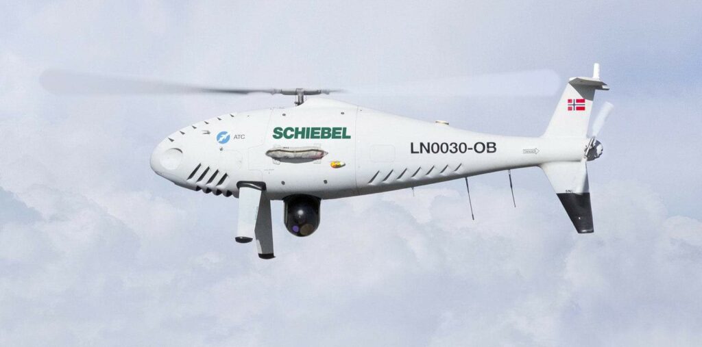
Schiebel stands as a leading global supplier of advanced mine detection technologies and the acclaimed CAMCOPTER® S-100 Unmanned Aerial System (UAS). This reliable vertical takeoff and landing (VTOL) unmanned helicopter is engineered to perform a diverse range of civilian and military tasks, even in the most demanding environments.
CAMCOPTER® S-100 Overview
Versatile VTOL UAS for Civil and Military Use
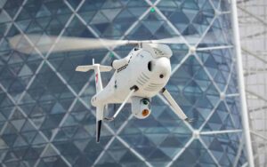
The Schiebel CAMCOPTER® S-100 is a high-performance VTOL UAS capable of operating in various weather conditions, both day and night. It is indeed known for its dependable performance, extensive operational range, precise navigation, and robust data interaction capabilities.
Users can either manually control the aircraft via the flight unit or set it for autonomous missions using GPS waypoints. The CAMCOPTER® S-100 is equipped with dual redundant Inertial Navigation Systems (INS) and Global Positioning Systems (GPS), ensuring remarkable navigation accuracy and stability.Its design allows for rapid deployment in the field without the need for a prepared takeoff or landing area. Real-time transmission of payload imagery, data, and status updates to the Ground Control Station is standard.
Key Specifications: Performance Metrics
| Maximum Airspeed (VNE) | 130 knots (240 km/h) IAS |
| Dash Speed | 120 knots (222 km/h) IAS |
| Loiter Speed | 55 knots (102 km/h) IAS for maximum endurance |
| Endurance | >6 hours with a 34 kg (75 lbs) payload; optional external fuel tank extends endurance to >10 hours |
| Service Ceiling | 18,000 ft in ISA conditions at reduced gross weight |
| Operating Temperature | -40°C to +55°C (-40°F to +131°F) |
| Wind (Takeoff and Landing) | Up to 25 knots (46 km/h) |
Technical specifications
| Main Rotor Diameter | 3400 mm (133.9”) |
| Total Length | 3110 mm (122”) |
| Total Height | 1120 mm (44”) |
| Maximum Takeoff Weight | 200 kg (440 lbs) |
| Empty Weight | 110 kg (243 lbs) |
| Payload Capacity | 50 kg (110 lbs) |
| Fuel Types | AVGAS, JP-5 (NATO F-44), Jet A-1 (NATO F-35) |
| Data Link Range | Up to 200 km (108 nm) |
Read more: CAMCOPTER® S-100 VTOL UAS
Payload Capabilities of CAMCOPTER® S-100
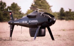
the CAMCOPTER® S-100 is a highly adaptable modular platform that can accommodate various payloads for multiple mission types. With a payload capacity of 50 kg (110 lbs), it features two payload bays, an auxiliary electronics compartment, two side payload hard points, and the option for underslung loads. This extensive adaptability allows the S-100 to deploy multiple sensors, including EO/IR cameras for imaging, ESM payloads for electronic signature detection, and real-time SAR radar capabilities, all within a single system.
Electro-Optical/Infrared (EO/IR) Systems
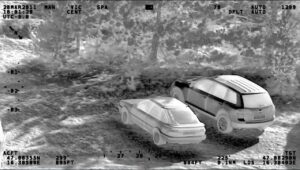
EO/IR gimbals enhance situational awareness and intelligence collection by identifying, categorizing, and geo-locating both static and moving targets. They provide real-time, high-definition video feeds to commanders for continuous surveillance of borders, urban areas, and events, day or night.
Synthetic Aperture Radar (SAR)
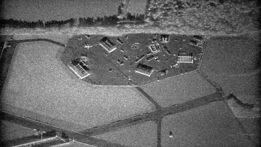
SAR technology utilizes the flight path of the UAS to create high-resolution remote sensing images, simulating a large antenna electronically. This system provides all-weather ground mapping and surveillance imaging, including Ground moving Target Indication (GMTI).
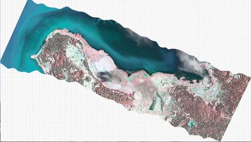
Laser Imaging Detection and Ranging (LIDAR)
LIDAR technology measures distances by illuminating targets with lasers and analyzing the reflected light.
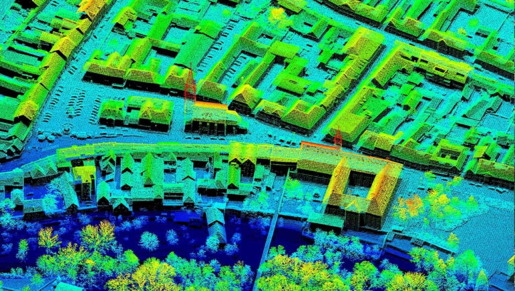
LIDAR systems are invaluable for 3D geographic surveys, allowing geologists and mapping professionals to analyze both natural and man-made environments with high accuracy, producing detailed maps and digital elevation models for geographic information systems.
Signals Intelligence (SIGINT)
SIGINT involves gathering intelligence through signal interception, whether from communications (COMINT) or other electronic signals. This capability enhances situational awareness and intelligence collection by identifying and geo-locating complex emitters, significantly improving monitoring and intelligence operations.
Hyperspectral Imaging
Hyperspectral imaging collects and processes data across the electromagnetic spectrum.
This technology is ideal for quickly and accurately mapping large geographic areas, aiding in the assessment of mineral resources and their meaning in local geological contexts.
read more: CAMCOPTER® Payload Capabilities
Civilian Applications of VTOL UAS
The CAMCOPTER® S-100’s adaptability and endurance make it an essential tool for both maritime and land-based civilian operations. From search and rescue missions to enhancing film production, the S-100’s user-friendly technology caters to a wide array of applications.
Search and Rescue Operations
Effective search and rescue missions rely on timely surveillance of extensive areas. The CAMCOPTER® S-100 equips NGOs, disaster response teams, and first responders with aerial insights that enhance resource deployment and coordination. Its ease of deployment and capability to operate day and night, combined with real-time high-definition video from both color and infrared cameras, make the S-100 a vital asset in these operations.
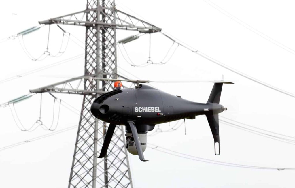
Power Line Monitoring
Utilizing unmanned helicopters for power line inspections enhances efficiency, allowing infrastructure to remain operational during assessments. This approach is especially beneficial in challenging terrains, improving safety and reducing inspection costs.
Airborne Laser Scanning
Airborne laser scanning demands precise, rapid, and repetitive surveys of large areas, such as forests and urban environments.equipping the S-100 with a high-precision laser scanner enables swift and accurate mapping of remote locations, proving invaluable for resource exploration and urban planning.
Aerial Filmmaking
The CAMCOPTER® S-100 can support various high-definition cameras, providing a stable platform for extended filming sessions. Its ability to hover and maneuver precisely allows for greater artistic flexibility, while its smaller aerial footprint is less intrusive than manned aircraft, facilitating filming in sensitive areas.
CBR Mapping
The S-100 serves as an excellent platform for collecting atmospheric samples, whether chemical, biological, or radiological (CBR). When equipped with LIDAR and color video sensors, its ability to hover and navigate accurately enables detailed 3D mapping of CBR clouds, providing critical data for geographers, resource extraction firms, and disaster response teams.
Anti-smuggling Efforts
As the need for robust border control increases, especially in challenging environments, the CAMCOPTER® S-100 has proven effective in delivering real-time intelligence for decision-makers and border patrol agents, making it an essential tool in combating contraband, drug trafficking, and organized crime.
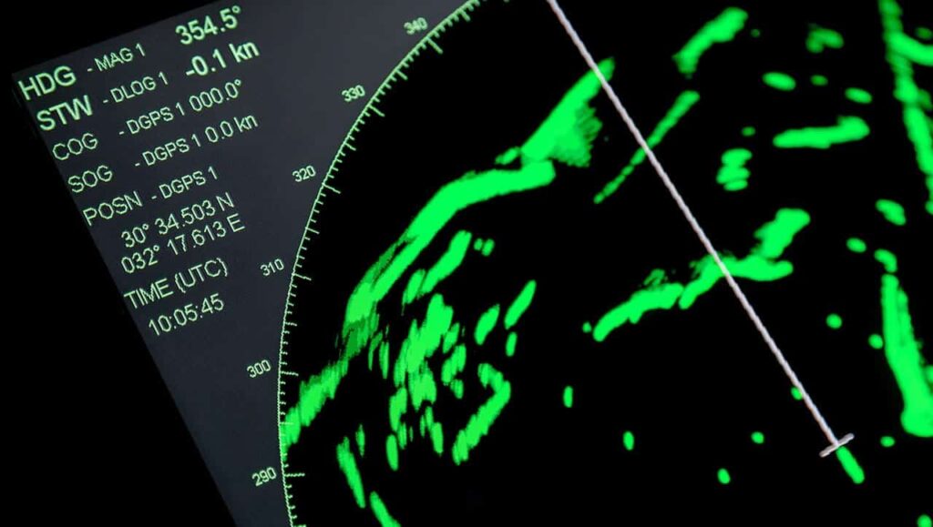
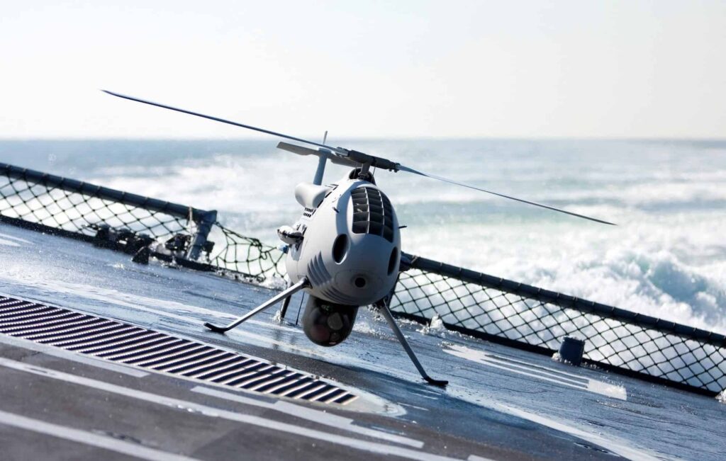
Coastal Surveillance
With shrinking budgets,naval design is shifting from large ships to smaller,more cost-effective solutions,complicating the operation of traditional manned helicopters. the CAMCOPTER® S-100 provides critical ISR capabilities and can operate from the decks of even smaller vessels due to its minimal footprint.
Read more: Civil applications
Military Applications of VTOL UAV
The CAMCOPTER® S-100 enhances military VTOL capabilities, offering intelligent and adaptable solutions for various missions. It operates effectively from austere locations and can be quickly reconfigured to meet diverse operational requirements, maintaining proximity to the center of action, whether on land or at sea.
Multi-Sensor Surveillance
The S-100 is unique in its class for its ability to carry multiple sensors concurrently, significantly enhancing the surveillance capabilities and situational awareness of naval commanders. The data collected is vital for understanding the complexities of maritime operations.
Extensive Oceanic Solution
The S-100 has successfully operated from over 30 different vessels across all oceans, demonstrating its maritime capabilities with thousands of flight hours. It features a fully automated shipboard landing system and has been tested in wind speeds of 4 knots and sea states exceeding 3.
Long-Distance Reconnaissance
The CAMCOPTER® S-100 provides long-range real-time reconnaissance capabilities up to 200 km, meeting a variety of user needs. Schiebel’s ground control interface supports mission planning and execution, allowing for seamless integration with higher command and control systems, including payload data distribution.
Flexible ISR Operations
Timely and focused ISR is crucial for modern military strategies. With a wide range of payload options and secure networking capabilities, the S-100 maximizes data collection and analysis efficiency. Its compact design and ability to operate from austere locations make it an ideal asset for intelligence, surveillance, and reconnaissance missions.
Mission Support Capabilities
Equipped with EO/IR cameras, loudspeakers, and leaflet-dropping containers, the CAMCOPTER® S-100 enhances decision-makers’ capabilities in various peacekeeping and stabilization operations.
Read more: Military VTOL Maritime Applications
