RTKdata offers access to a premier RTK corrections data network, featuring over 12,000 base stations across more than 140 nations. Our mission is to provide the highest precision GNSS RTK data, ensuring remarkable real-time positioning capabilities for drones, robotics, and autonomous vehicles.
Centimeter-Level Accuracy in Real-Time GNSS Positioning
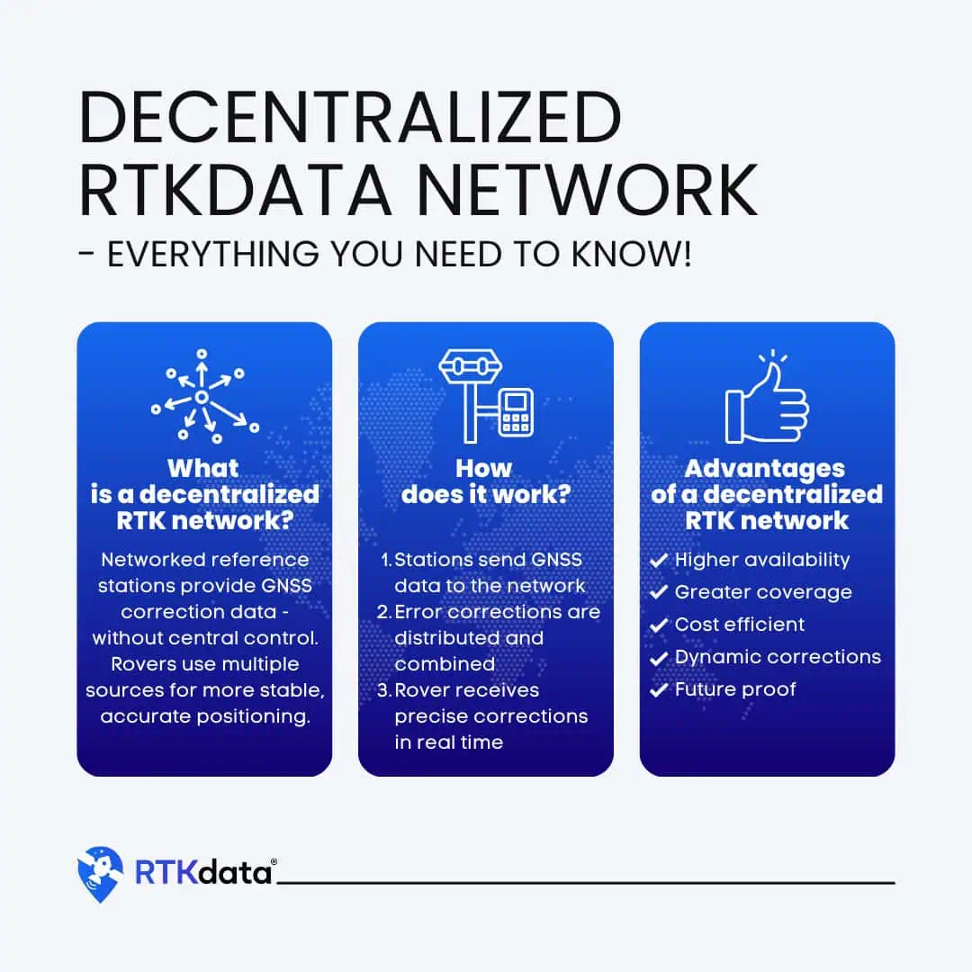
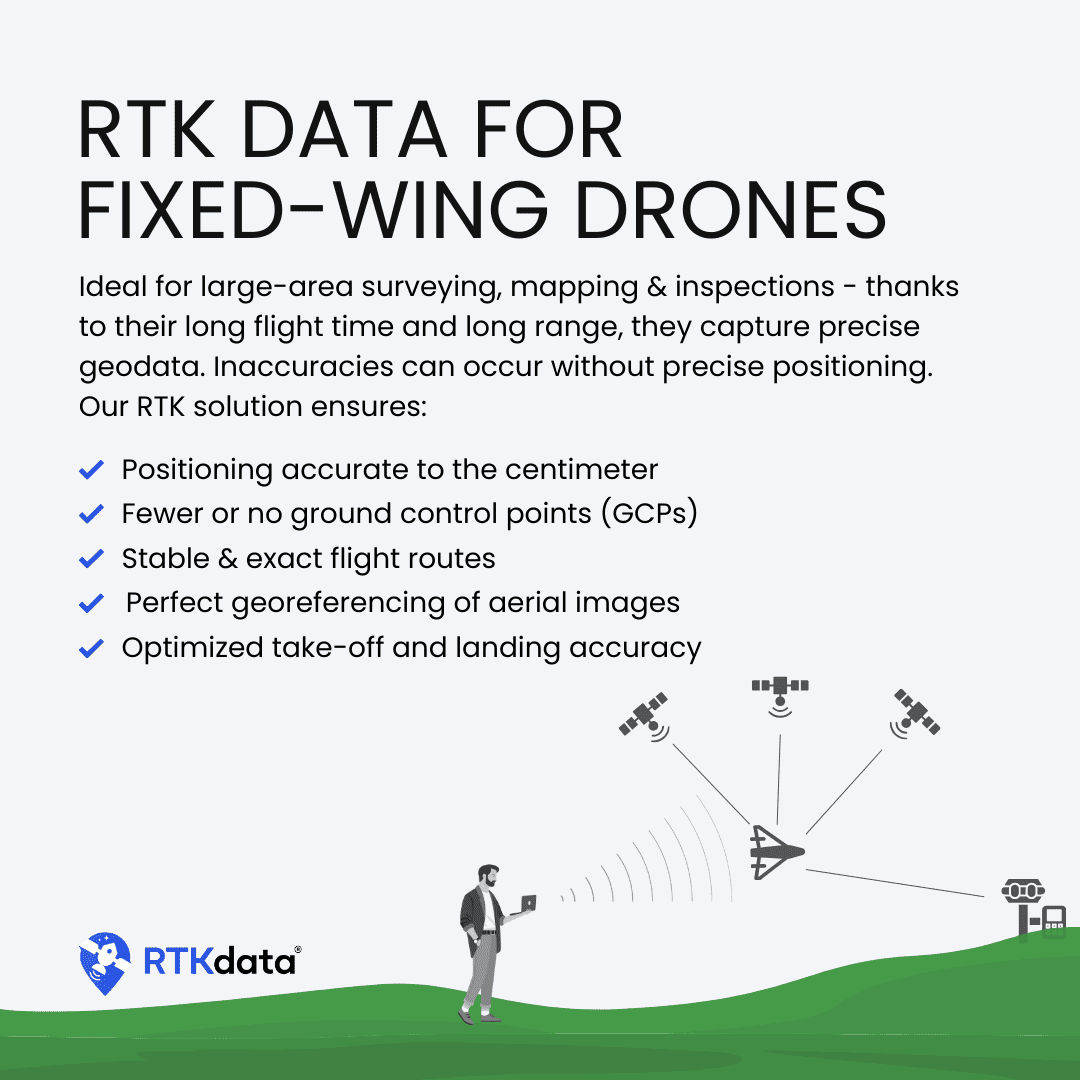
RTKdata enhances GNSS accuracy through a decentralized network of fixed base stations, improving the positioning data derived from standard GNSS constellations such as GPS, GLONASS, Galileo, and BeiDou. These stations transmit real-time corrections to drones, UGVs, and other rover units, achieving horizontal accuracy of 1-2 cm and vertical accuracy of 2-3 cm.

To explore a global coverage map of the RTK data network, click here >>
With support for triple-frequency and multiple constellations, RTKdata’s services can be effortlessly integrated with a variety of existing GNSS equipment using RTCM3.2 and NTRIP protocols, offering a cost-effective solution to enhance your drones and robotic systems.
Why Opt for RTKdata?
Our state-of-the-art RTK solution offers a unique array of benefits for operators and service providers in various sectors, including mapping, surveying, construction, agriculture, and logistics.
Precision & Accuracy – Our RTK corrections considerably reduce errors from atmospheric conditions and signal interference, achieving precision levels of 1-2 cm horizontally and 2-3 cm vertically. This performance is essential for applications demanding exact positioning, such as autonomous vehicle navigation and professional surveying.
extensive Coverage – RTKdata’s vast decentralized network of base stations provides RTK corrections via the internet, ensuring wide-ranging coverage and dependable real-time data transmission.
Scalability – RTKdata accommodates thousands of simultaneous users, making it suitable for all your precise positioning needs, nonetheless of scale. The network can be easily expanded by adding additional base stations as demand grows.
User-Kind Integration – RTKdata is compatible with moast GPS and GNSS devices and drone platforms available today. The system can be seamlessly integrated using industry-standard protocols like RTCM 3.2 and NTRIP.
Dependability – By employing redundant base stations, the RTKdata network guarantees continuous availability, providing real-time data corrections with sub-second latency. All base stations are monitored around the clock using Precise Point Positioning (PPP).
Innovation & Future-Readiness – RTKdata supports all major GNSS constellations, including GPS, GLONASS, Galileo, and BeiDou, ensuring maximum accuracy and reliability. We leverage cutting-edge real-time data processing and error correction technologies, keeping us at the forefront of innovation and ensuring your drones and autonomous vehicles remain future-ready.
Flexible Pricing & Complimentary Trial
We provide standard monthly and annual single-license agreements,along with customizable licenses tailored to your needs,accommodating as manny users as required. An optional free RTK Base Station is included with any pricing plan,enhancing the accuracy of GNSS data in your area.
A complimentary 30-day trial of RTKdata is also available, granting you access to all core features of the service for an introductory period without any commitment or upfront fees.