IMSAR is revolutionizing radar technology by developing compact, lightweight synthetic aperture radar (SAR) systems designed for integration with drones and unmanned aerial vehicles (UAVs). Our radars, which are low in size, weight, and power (Low SWaP), enhance electro-optical/infrared (EO/IR) and electronic warfare (EW) payloads, delivering sophisticated geospatial intelligence capabilities that are usually found on larger platforms, operational in all weather conditions, both day and night.
IMSAR’s radar suite empowers users to plan missions, gather imagery, and convert radar data into actionable insights through various user-amiable data products, including high-resolution SAR images, Coherent Change Detection (CCD) outputs, and Moving Target Indicator (MTI) streams.
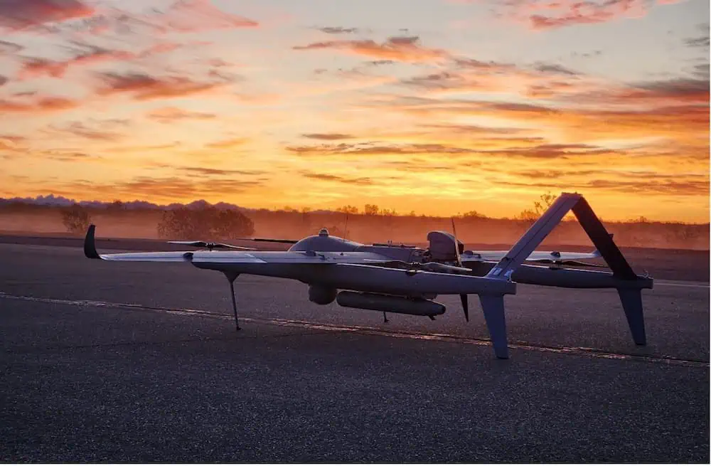
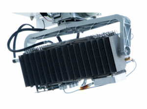
NSP-2 Synthetic Aperture Radar
Versatile UAV SAR for Multiple Domains
Tailored for Group 1 and 2 UAS, the NSP-2 is a lightweight, multi-functional SAR/GMTI payload that delivers critical intelligence for both terrestrial and maritime applications.
The NSP-2 operates with just power and Ethernet, and can be managed through our user-friendly Lisa 3D Command and Control (C2) and Processing, Exploitation, and Dissemination (PED) software. A Radar Control API is also available for seamless integration with third-party and custom software solutions.
The NSP-2 can connect to a Ground Processing Server via a datalink for immediate data processing, or it can store radar data onboard for analysis after the mission.
Discover more: NSP-2 Synthetic Aperture Radar
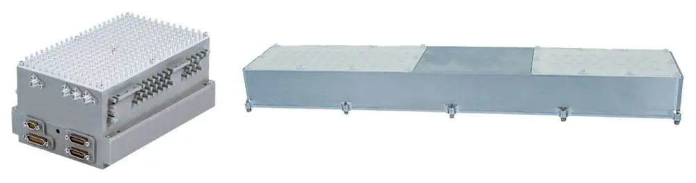
NSP-3 Synthetic Aperture Radar
All-Weather Multi-Mode SAR for UAVs
The NSP-3 is engineered for all-weather operations, suitable for both land and maritime missions, functioning effectively day and night. This low-SWaP system is available in a Mod-Payload configuration,allowing for easy integration with an externally mounted antenna pod and internal electronics,or any custom mounting setup.

The NSP-3 requires onyl power, Ethernet, and a GPS antenna connection, and can be operated through our user-friendly Lisa 3D Command and control (C2) and Processing, Exploitation, and Dissemination (PED) software. A Radar Control API is also available for straightforward integration with third-party and custom software.
The NSP-3 can connect to a Ground Processing Server via a datalink for real-time data processing, or it can store radar data onboard for post-mission analysis.
Discover more: NSP-3 Synthetic Aperture Radar
NSP-5 Multi-mode Radar
Tactical MTI SAR for Land and Maritime Operations


The NSP-5 is a low SWaP multi-mode SAR/MTI radar system designed to provide real-time actionable intelligence when deployed with tactical UAVs in both land and maritime settings. Housed in a robust weatherproof pod, the system can be mounted using a swift-connect rail with blind mate connections, a strongback rail, or even as a quick attach/release with MIL-Spec 14” lug mounts.
The NSP-5 requires only power and Ethernet for operation and can be managed through our intuitive Lisa 3D Command and Control (C2) and Processing, Exploitation, and Dissemination (PED) software. A Radar Control API is also available for seamless integration with third-party and custom software solutions.
The NSP-5 can connect to a Ground Processing Server via a datalink for real-time data processing, or it can store radar data onboard for post-mission analysis.
 and Processing, Exploitation, and Dissemination (PED) software")
Discover more: NSP-5 Multi-Mode Radar
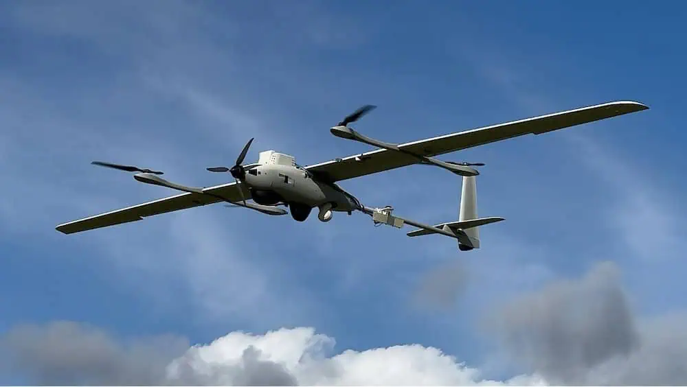
NSP-7 Long-Range Radar
Extended-Range SAR for Large UAVs


The NSP-7 is a long-range multi-mode SAR designed for larger UAVs, capable of imaging targets at distances up to 55 km with a resolution of 1 meter, providing high-performance intelligence-gathering capabilities in all weather conditions, day or night.
The NSP-7’s durable weatherproof pod requires only power, Ethernet, and a GPS antenna connection, and can be mounted using MIL-Spec 14” lug mounts or via an adapter plate to the pod’s strongback rail. Custom integration solutions can also be designed for specific UAVs.
The user-friendly NSP-7 can be operated through our intuitive Lisa 3D Command and Control (C2) and Processing, Exploitation, and Dissemination (PED) software.
Developers can also utilize a Radar Control API for seamless integration with custom or third-party software.

The NSP-7 can be paired with an onboard Airborne Processing Server or connected via a datalink to a Ground Processing Server for real-time data processing. Additionally,radar data can be stored onboard for post-mission analysis.
Discover more: NSP-7 Long-Range Radar
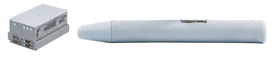
PSAR Stratospheric Radar
Multi-Mode Synthetic Aperture Radar for Stratospheric UAVs
PSAR is a low-SWaP SAR designed to equip high-altitude long-endurance (HALE) UAVs, high-altitude pseudo-satellites (HAPS), unmanned balloons, and other stratospheric platforms that previously lacked radar capabilities.
utilizing our military-proven NanoSAR technology, this innovative system features a low-loss, additive-manufactured aluminum antenna that serves as both a structural and thermal component while transmitting and receiving radar signals, optimizing space and weight. The unit can connect to a Ground Processing Server via a datalink for real-time data processing.
PSAR can be controlled through our user-friendly Lisa 3D Command and Control (C2) and Processing, Exploitation, and Dissemination (PED) software. A Radar Control API is also available for seamless integration with third-party and custom software solutions.
Discover more: PSAR Stratospheric Radar
Lisa 3D – C2 & PED software for Actionable Intelligence
extensive Mission Planning and Multi-Sensor Data Processing

Lisa 3D is a comprehensive software solution that facilitates intuitive mission planning and data management for various sensors. It enables operators to conduct real-time data analysis from radars, EO/IR payloads, vessel AIS, and other sources, generating actionable intelligence for enhanced decision-making.
Drone operators can develop detailed data collection strategies for multiple sensors and modes, which can then be used to create flight plans.Lisa 3D offers real-time sensor tracking and flight characteristic monitoring, allowing mission plans and collection modes to be adjusted dynamically.
Lisa 3D supports a variety of file formats for import and export, making it easy to view, annotate, and mark data products from multiple sensors.
Discover more: Lisa 3D – C2 and PED Software for Actionable Intelligence
Applications & Capabilities
Maritime Surveillance
our SAR systems empower UAVs to monitor maritime and coastal areas through extensive searches, automatically identifying objects and distinguishing vessels and semi-submersibles from the surrounding sea clutter.


Moving Target Indication (MTI)
by employing multiple receiving antennas along the UAV’s length, MTI radar systems can analyze the Doppler effect of reflected signals, differentiating between moving and stationary objects, and providing real-time tracking of both fast and slow-moving targets.
 Radar")

Coherent Change Detection (CCD)
CCD utilizes images of the same area captured during different UAV flights to assess changes over time, providing critical intelligence that may be overlooked in a single pass.
 Radar")


