satlab Geosolutions stands at the forefront of developing cutting-edge RTK GNSS positioning technologies, handheld SLAM scanners, marine and water resource solutions, and also total stations. With over four decades of expertise in the GNSS sector and a robust commitment to research and innovation, the company provides state-of-the-art solutions tailored for mapping and surveying professionals globally.
Innovative Swedish engineering
For surveyors and geospatial experts, precision and accuracy are paramount for successful project outcomes. At SatLab Geosolutions, we take pride in our ability to deliver solutions that fulfill these requirements through advanced Swedish engineering. Our products undergo stringent quality checks to ensure they meet our high standards, providing reliable and innovative technology from the outset of your work.
Explore Our Products:
- GNSS RTK Receivers
- 3D Scanners
- Handheld Controllers
- Marine & Water Resources
GNSS RTK Receivers
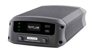
Freyja GNSS RTK Receiver
Multi-functional RTK-enabled UAV base station
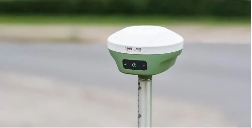
The Freyja is a sophisticated RTK-capable GNSS receiver, perfectly suited for use as a UAV base station in professional mapping and surveying tasks. It provides highly dependable GNSS corrections, ensuring top-notch accuracy. This full-constellation, full-frequency receiver is an essential asset for field surveyors.
At a lightweight of just 800g, this robust receiver is portable and easy to set up, boasting a battery life exceeding 12 hours. Its advanced built-in antenna is designed to minimize interference and track signals at low elevation angles. With cutting-edge tilt compensation algorithms and a high-performance 9-axis IMU, it ensures stable results even in challenging conditions.
Discover more: Freyja GNSS RTK Receiver
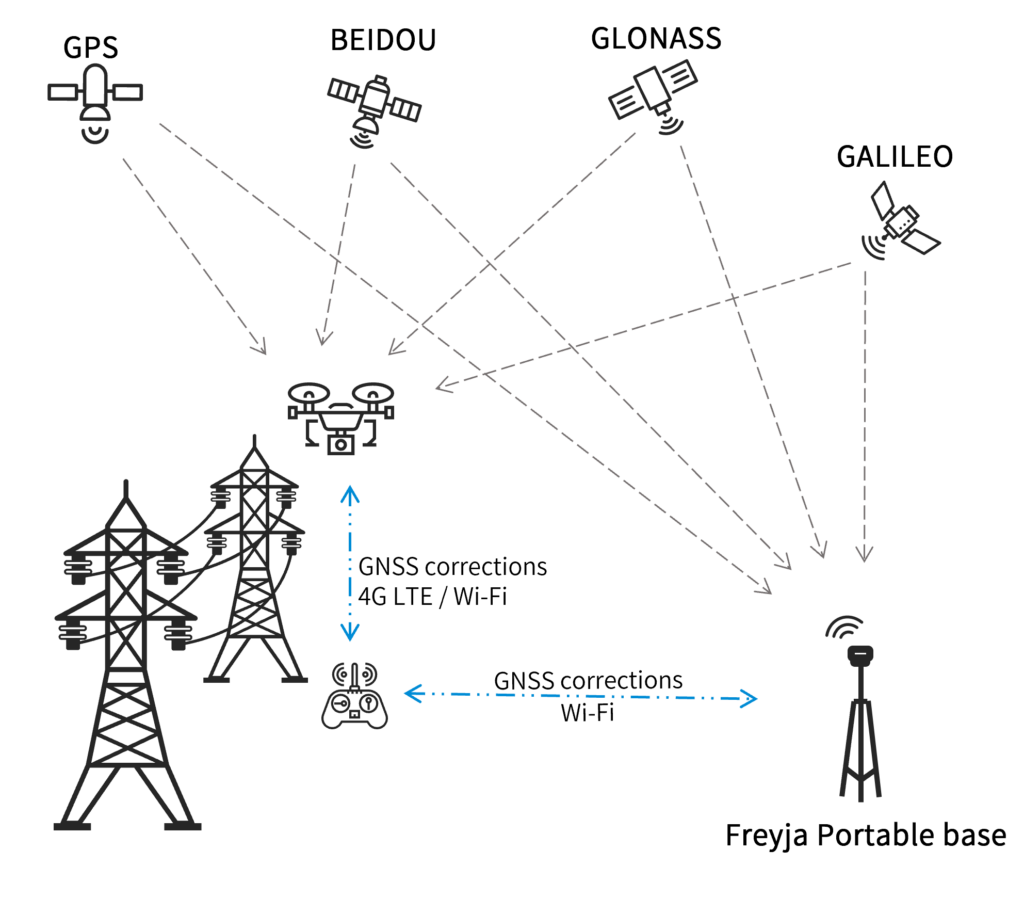
Case Study: Implementing the Freyja GNSS Receiver for UAV Operations
This case study illustrates how the SatLab Freyja GNSS receiver serves as a GNSS base station, providing precise correction data for UAVs, thereby enhancing deliverable accuracy and improving navigation experiences. Read the case study >
Eyr GNSS RTK System
GNSS receiver equipped with dual cameras for surveying and stakeout
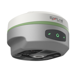
the Eyr is a sophisticated RTK-capable GNSS receiver featuring dual high-definition cameras for remote data collection, making it perfect for stakeouts, elevation surveys, and operations in hazardous or hard-to-access locations.
The integrated multi-protocol radio transceiver supports various RTK data sources and typically operates over a range of 7km outdoors. Eyr’s advanced hardware enhances satellite tracking and provides superior anti-jamming and interference suppression.
Learn more: eyr GNSS RTK System
GS-1 GNSS Sensor
Full-constellation single/dual-antenna GNSS receiver for drones and robotics
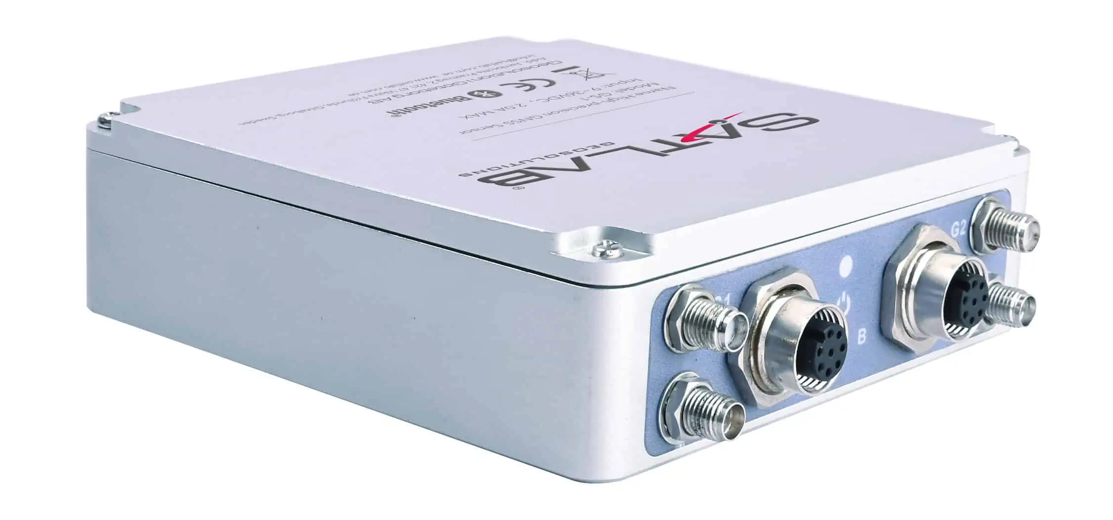
The GS-1 is a versatile full-constellation GNSS receiver designed as a cost-effective positioning solution, supporting both single and dual-antenna configurations.
Equipped with a powerful CPU and an integrated Linux operating system, the receiver can be configured via a built-in web server. It offers multiple communication options, including WiFi, Bluetooth, 4G, and RS232 serial, allowing for simultaneous transmission of high-precision positioning data.
Learn more: GS-1 GNSS Sensor
3D Scanners
Apus-MX LiDAR Scanner
UAV LiDAR scanner with an orthographic camera
The Apus-MX is a high-precision UAV surveying system that integrates a powerful long-range LiDAR scanner with an advanced IMU and an industrial-grade RGB orthographic camera, offering a highly portable and quickly deployable solution. With an 80° field of view and a maximum range of 1200 meters, it captures extensive data in a single flight, enhancing efficiency and cost-effectiveness.This adaptable scanning system can navigate complex terrains and urban settings effortlessly, and is capable of penetrating dense vegetation, making it ideal for generating digital elevation models (DEM) and digital surface models (DSM).
Learn more: Apus-MX LiDAR Scanner
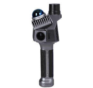
Cygnus Handheld SLAM Scanner
Mobile 3D scanner for accurate point cloud acquisition
Cygnus is a mobile laser scanner designed for high-precision point cloud data collection and 3D modeling, utilizing advanced SLAM (Simultaneous Localization And Mapping) technology and algorithms. Data processing can occur in the field with real-time decoding software, allowing for immediate export once scanning is complete.
This versatile system can be easily mounted on UAVs and mobile mapping vehicles, making it suitable for a variety of applications, including construction surveys, environmental monitoring, and modeling in GNSS-denied environments.
Learn more: Cygnus Handheld SLAM Scanner
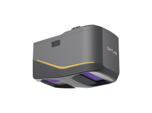
Cygnus 2 Handheld SLAM Scanner
Portable scanner with centimeter-level precision
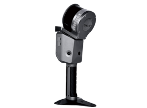
The Cygnus 2 handheld mobile scanner integrates advanced LiDAR with visual fusion SLAM technology and RTK GNSS, achieving accuracy down to 1.5cm. Weighing onyl 1.9kg and offering a 90-minute battery life,it enables the completion of extensive projects in a single outing while reducing operator fatigue. The device provides instant 3D modeling and data export,making it ideal for various applications,including topographic mapping,volume calculations,agriculture,and construction.
Learn more: Cygnus 2 Handheld SLAM Scanner
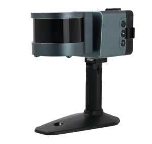
Cygnus Lite Handheld SLAM Scanner
Ultra-lightweight mobile scanner with dual wide-angle cameras
The Cygnus Lite is a highly portable SLAM scanner featuring a 20° tilt mechanism and dual 12MP HD wide-angle cameras for capturing detailed and colorized point clouds and 3D imagery.Weighing just 1 kg,it allows for extended operations in confined or hard-to-reach areas without causing fatigue.
The device’s integrated RTK module can connect to CORS networks via cellular connections, enhancing survey accuracy.
Learn more: Cygnus Lite Handheld SLAM Scanner
Lixel X1 Handheld SLAM Scanner
Lightweight 3D scanner for mapping and surveying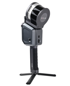
Lixel X1 is a lightweight 3D scanner that offers powerful real-time scene reconstruction, supported by SatLab’s next-generation SLAM technology. Data can be exported immediately after scanning, eliminating the need for post-processing, thus streamlining workflows and saving time for surveyors.
The adaptable scanner provides up to 60 minutes of continuous operation and can be easily mounted on UAVs and other mobile mapping platforms.
Learn more: Lixel X1 Handheld SLAM Scanner
Handheld Controllers
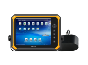
TBA Rugged Tablet
Industrial-grade handheld tablet for field applications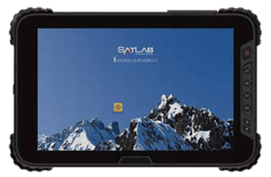
The TBA is an Android-based handheld tablet designed for intuitive control of UAVs and unmanned systems in the field. It features a 10-inch sunlight-readable display and is built to endure harsh environmental conditions, meeting IP67 and MIL-STD-810G standards.
The tablet comes with integrated 3G and 4G LTE cellular connectivity,including voice telephony support. An optional high-precision GNSS-enabled version is available for professional GIS applications.
Learn more: TBA Rugged Tablet
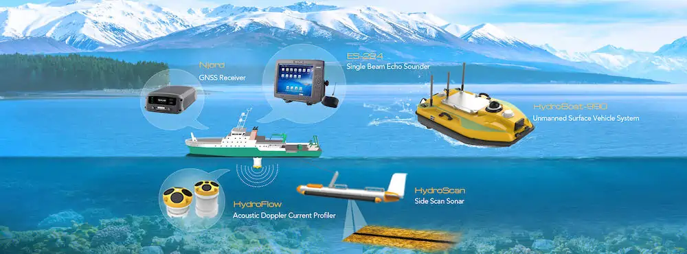
Marine & Water Resources
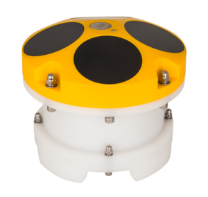
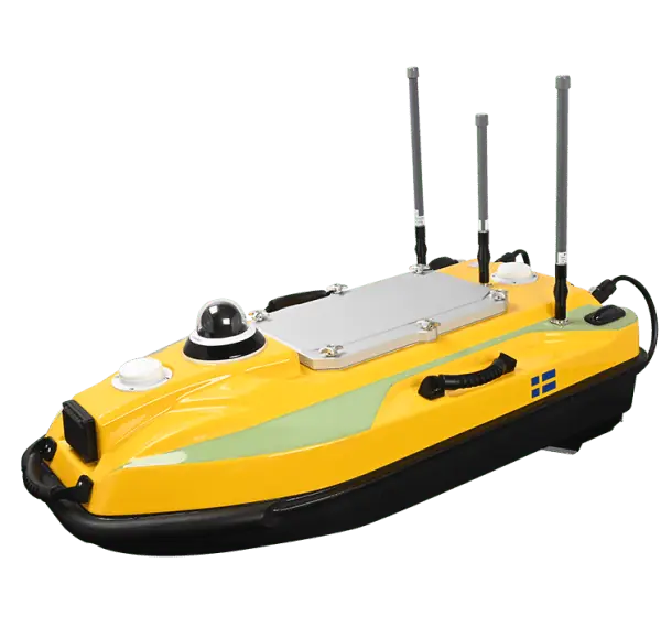
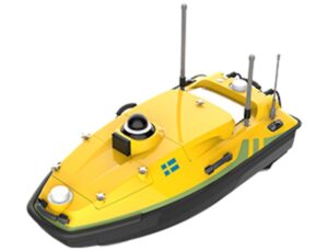
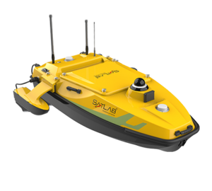
Njord GNSS Receiver
Multi-constellation receiver for marine applications
The Njord is a multi-frequency, multi-constellation GNSS receiver designed to deliver accurate positioning and heading for marine applications, such as Uncrewed surface Vessels (USVs). It can receive corrections via L-band,and offers communication options including UHF radio,cellular,Wi-Fi,Bluetooth,USB,and Ethernet.The receiver is equipped with three hours of emergency power reserve, allowing it to enter standby mode in case of unexpected power loss.
Learn more: Njord GNSS Receiver
hydroscan Side scan Sonar
Towed sonar with dual-frequency capabilities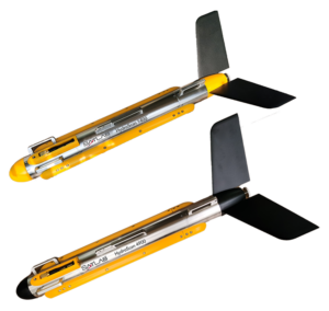
The HydroScan is a towed side scan sonar system that employs simultaneous dual-frequency scanning to deliver clear underwater imagery, seamlessly switching between continuous waveform and chirp modes. Its ultra-narrow beam angle of 0.2° allows for a resolution of up to 1.25cm, facilitating the identification of smaller objects.
Frequency options include 100, 400, and 900 kHz. HydroScan is suitable for a variety of applications, including cable and pipeline surveys, mine countermeasures, dredging, archaeology, and search and recovery operations.
Learn more: HydroScan Side Scan Sonar
HydroFlow ACDP
Current profiling system with flexible deployment options
The HydroFlow is an Acoustic Doppler Current Profiler that can be mounted on various unmanned marine platforms,including USVs,UUVs,and buoys,providing an accurate and user-friendly discharge and flow monitoring system.
Utilizing advanced broadband signal processing technology, the HydroFlow ADCP enhances anti-noise performance and achieves measurement accuracy of up to 0.25% ± 0.25cm/s.
Learn more: HydroFlow ACDP
HydroBeam S2 Echo Sounder
Dual-channel echo sounder for USV surveys
The HydroBeam S2 is a dual-channel echo sounder that simplifies bathymetric survey tasks for USVs. It features a robust windows 10-based acquisition unit and a high-precision transducer with an integrated temperature sensor. The system provides a comprehensive workflow for data acquisition,processing,correction,and export,making it ideal for applications such as deep-water exploration,reservoir assessments,and dredging.
Learn more: HydroBeam S2 Echo Sounder
HydroBoat 990 USV
Efficient USV for bathymetric surveys
The HydroBoat 990 is a portable and user-friendly USV (uncrewed surface vessel) platform designed for conducting bathymetric surveys with a single operator. It features an integrated GNSS receiver and SBES echosounder, offering both manual and automated control options.
This durable vessel is rated IP67 for maximum resilience and includes a millimeter-wave radar for precise obstacle detection and safe navigation.
Learn more: HydroBoat 990 USV
HydroBoat 1200 USV
Multipurpose uncrewed vessel for hydrographic surveys and monitoring
The HydroBoat 1200 is a compact and versatile USV designed to accommodate a wide range of measurement sensors and equipment, providing a true multi-mission solution. Capable of full autonomy, the vessel can navigate predefined routes even in challenging conditions.
It features a built-in IMU,GNSS receiver,SBES echosounder,360° PTZ camera,and mmWave radar. With a 240mm moon pool, it can be outfitted with ADCPs, side-scan sonars, water quality meters, and more.
Learn more: HydroBoat 1200 USV
HydroBoat 1500 USV
Versatile USV for underwater topographic surveys
The HydroBoat 1500 is a versatile USV designed for conducting underwater topographic surveys of lakes, rivers, reservoirs, and other water bodies. With a payload capacity of 60 kg,it is ideal for equipping with our HydroBeam M4 portable multibeam echosounder,as well as various other payloads.
This robust vessel is rated IP67 for maximum durability and includes a millimeter-wave radar and a 360° omnidirectional camera for accurate obstacle detection and safe navigation.
Learn more: HydroBoat 1500 USV
applications

UAV Mapping
Our GNSS solutions are perfectly suited for executing high-accuracy aerial photogrammetry missions with UAVs, capturing precise geotagged imagery for the progress of orthophotos, maps, and other products.
Drone-Based Surveys
SatLab’s GNSS and RTK surveying equipment facilitates efficient data collection in challenging environments,enabling surveyors to accurately measure stockpile volumes,create 3D LiDAR models,and plan construction and mining operations,among other tasks.


