Inertial Labs stands at the forefront of designing and producing advanced tracking systems for unmanned vehicles. Our precision solutions leverage the integration of inertial navigation sensors alongside a variety of innovative sensing technologies, such as MEMS-IMU, accelerometers, gyroscopes, and AHRS. With our engineering prowess, we develop high-performance inertial sensor systems that are compact and energy-efficient.
Our offerings are perfectly suited for numerous applications in unmanned systems, including motion tracking, weapon orientation, payload stabilization, and inertial position tracking in environments where GPS signals are unavailable.
Navigate to Section:
- RESEPI – Remote Sensing Payload Instrument
- Inertial Measurement Units (IMUs)
- Attitude and Heading Reference Systems (AHRS)
- GPS-Aided Inertial Navigation Systems (INS)
- Multi-Axis Gyros
- Three-Axis Accelerometers
- Motion Reference Units
- wave sensors
Inertial Measurement Units (IMU)
IMU-FI-200T Inertial Measurement Unit
Tactical-grade FOG-based IMU
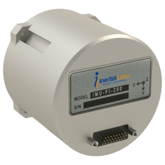
The IMU-FI-200T is a compact tactical-grade IMU that features three-axis FOGs and high-precision MEMS accelerometers, providing accurate linear acceleration and angular rate data with minimal noise and remarkable reliability.
This sensor is fully calibrated and temperature-compensated, rigorously tested to endure extreme temperature fluctuations, high vibrations, and shocks.
Ideal for both static and dynamic applications,the IMU-FI-200T excels in UAV and UUV navigation and control,platform and antenna stabilization,and integration into AHRS and INS systems.
Learn More: IMU-FI-200T Inertial Measurement Unit
IMU-NAV-100 Inertial Measurement Unit
navigation-grade high accuracy IMU
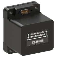
The IMU-NAV-100 is a lightweight, high-accuracy IMU utilizing advanced MEMS sensor technology, delivering three-axis linear accelerations and angular rates with low noise and high reliability.
Fully calibrated and temperature-compensated, the IMU-NAV-100 is mathematically aligned to an orthogonal coordinate system, ensuring high accuracy in both static and dynamic conditions.
With continuous Built-in test (BIT), configurable communication protocols, electromagnetic interference (EMI) protection, and adaptable power input requirements, this unit is perfect for UAV, AUV, and ROV navigation and control, as well as platform orientation and stabilization. It comes in two performance variants.
Learn More: IMU-NAV-100 inertial Measurement Unit
IMU-P Inertial measurement Unit
High Performance Tactical Grade & Industrial IMU
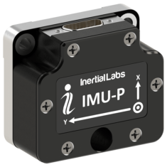
The IMU-P is a compact,high-performance Inertial Measurement Unit designed for various applications,including UAV and AUV/ROV navigation and control.
This MEMS IMU features three highly accurate Advanced MEMS gyroscopes and three ultra-high-performance accelerometers for precise linear acceleration and angular rate measurements.
The IMU-P is an ITAR-free inertial solution, fully calibrated and compensated across its operational temperature range. Both Industrial and Tactical grade units are available.
Its compact dimensions (39 x 45 x 22 mm) and lightweight (70 grams) make it ideal for integrated system applications.
IMU-P Applications:
- Antenna and Line of Sight Stabilization Systems
- Motion Reference Units (MRU)
- Motion Control Sensors (MCS)
- Gimbals, EOC/IR, platform orientation and stabilization
- UAV & AUV/ROV navigation and control
Learn More: IMU-P Inertial Measurement Unit
Kernel Inertial measurement Units
Fully-integrated industrial and tactical-grade IMUs
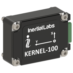
The Kernel series of strapdown three-axis IMUs utilizes the latest MEMS IMU sensor technology, offering various options to meet both industrial and tactical-grade needs.
These fully-integrated IMUs provide linear acceleration and angular rate outputs through three-axis MEMS accelerometers and gyroscopes, and have been rigorously tested to endure extreme temperature variations, high vibrations, and shocks.
These tactical and industrial IMUs can be seamlessly integrated into MRUs, AHRS, and GNSS-INS, making them suitable for a wide range of drone and robotics applications, including autonomous vehicles, antenna stabilization systems, and vessel motion monitoring.
Learn More: Kernel Inertial Measurement Units
Attitude and Heading Reference Systems (AHRS)
AHRS-10 – High Accuracy AHRS
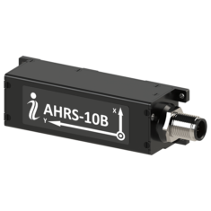
The AHRS-10 is a high-precision AHRS that provides absolute orientation (heading, pitch, and roll) for both static and dynamic applications. It integrates high-accuracy 3-axis accelerometers, magnetometers, and gyroscopes to deliver precise pitch and roll data, real-time device rotation data, and continuous gyroscope corrections.
Utilizing our advanced Fluxgate Magnetometer technology, the AHRS-10 ensures superior stability and repeatability, making it an excellent choice for unmanned systems requiring high accuracy.
Applications:
- Point-to-point antenna stabilization and motion control
- Antenna Reference Units (ARU)
- Radar Reference Units (RRU)
Learn More: AHRS-10 Attitude and Heading Reference System
AHRS-II – Absolute Orientation AHRS
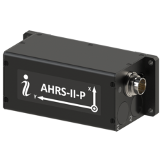
The AHRS-II represents our next-generation AHRS,equipped with cutting-edge algorithms for a variety of dynamic motions in unmanned vehicles.It features precision 3-axis accelerometers, magnetometers, and gyroscopes to provide heave, heading, pitch, and roll data, along with high-frequency real-time device rotation data and ongoing gyroscope corrections.
OptoAHRSTM-II employs reference images,which are essentially pictures of the horizon in a specific direction,allowing the system to identify a constellation of recognizable features within the reference image.
Applications:
- Antenna pointing systems
- Geospatial systems
Learn More: AHRS-II Attitude and Heading Reference System
miniAHRS – Miniature AHRS
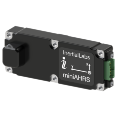
The miniAHRS is a lightweight,compact AHRS designed for integration into small drones and unmanned systems.It combines 3-axis accelerometers, magnetometers, and gyroscopes to deliver absolute pitch and roll data, real-time three-axis rotation measurements, and continuous gyroscope corrections.
Featuring advanced Kalman filter-based sensor fusion techniques and state-of-the-art algorithms, the miniAHRS is optimized for the dynamic motions of various unmanned vehicles and robotic platforms across land, sea, and air.
miniAHRS Applications:
- Low-SWaP UAVs and unmanned systems
- Weapons systems fire control
Learn More: miniAHRS – Miniature AHRS
GPS-aided Inertial Navigation sensors
GPS-INS for Unmanned Vehicles
Our range of GPS-Aided Inertial Navigation Systems integrates support for multi-GNSS constellation signals (L1 & L2 GPS, GLONASS, GALILEO, and BEIDOU) with advanced 3-axis accelerometers, magnetometers, and gyroscopes to deliver precise position, velocity, heave, and absolute orientation data for unmanned aircraft and ground robotics. Both single- and dual-antenna GPS-INS options are available.
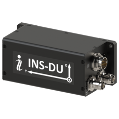
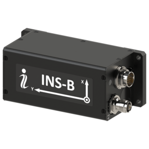
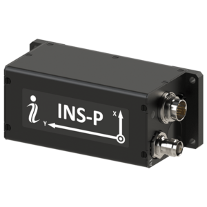
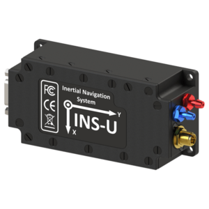
Single-Antenna GPS-INS
Our single-antenna GPS-aided INS comes in three models. Both the INS-P and INS-U feature an embedded high-precision gyro-compensated magnetic compass for improved heading performance in GNSS-denied environments, even under challenging conditions.
The INS-U also includes an integrated Air Data Computer (ADC) that provides parameters such as static and dynamic pressure, airspeed, Mach number, and angle of attack.
Specifications:
|
|
|
|
|
| Model | INS-B (Basic) | INS-P (Professional) | INS-U |
| Size | 120 x 50 x 53 mm | 120 x 50 x 53 mm | 82.0 x 40 x 26 mm |
| Weight | 220g | 280g | < 200g |
| Position Accuracy | 1.5 m (GPS L1) 1.2 m (GPS L1 & L2) 0.6 m (SBAS) 0.4 m (DGPS) 0.05 m (PP) 0.01 m + 1 ppm (RTK) |
1.5 m (GPS L1) 1.2 m (GPS L1 & L2) 0.6 m (SBAS) 0.4 m (DGPS) 0.05 m (PP) 0.01 m + 1 ppm (RTK) |
1.5 m (GPS L1) 1.2 m (GPS L1 & L2) 0.6 m (SBAS) 0.4 m (DGPS) 0.05 m (PP) 0.01 m + 1 ppm (RTK) |
Precision Navigation with Dual-Antenna GPS-INS
Our dual-antenna GPS-assisted Inertial Navigation system (INS) sensors significantly enhance the accuracy of positioning and heading for unmanned vehicles, whether in stationary or moving scenarios.
Technical Specifications
| Model A | Model B | Model C | |
| Horizontal Position Accuracy | 1.5 m (GPS L1) 1.2 m (GPS L1 & L2) 0.6 m (SBAS) 0.4 m (DGPS) 0.05 m (PPP) 0.01 m + 1 ppm (RTK) |
1.5 m (GPS L1) 1.2 m (GPS L1 & L2) 0.6 m (SBAS) 0.025 m (PPP) 0.01 m + 1 ppm (RTK) |
1.5 m (GPS L1) 1.2 m (GPS L1 & L2) 0.4 m (DGPS) 0.005 m (PPP) 0.01 m + 1 ppm (RTK) |
| Heading Accuracy (static | dynamic) |
1 deg | 0.1 deg | 0.4 deg | 0.1 deg | 0.3 deg | 0.6 deg |
| Velocity Accuracy | 0.03 m/sec | 0.03 m/sec | 0.05 m/sec |
| Pitch & Roll Accuracy (dynamic) |
0.1 deg | 0.1 deg | 0.08 deg |
| Gyroscope Bias Stability | 1 deg/hr | 1 deg/hr | 2 deg/hr |
| Accelerometer Bias Stability | 0.005 mg | 0.005 mg | 0.01 mg (±8g) 0.03 mg (±15g) 0.05 mg (±40g) |
Advanced OEM Solutions
We offer OEM versions of our INS-B, INS-D, and INS-DL models, which are designed for industrial and tactical applications. Compact in size at just 85 x 47 x 36 mm and weighing between 115 to 160g, these units are perfect for platforms where size, weight, and power (SWaP) are critical.
Applications of INS Technology
- UAV and drone navigation in GPS-denied environments
- Remote sensing and data collection
- Low-altitude aerial photography
- Law enforcement operations
- Autonomous vehicle navigation
- Aerial inspections of infrastructure such as roads and power lines
- Surveying and 3D mapping
- Precision agriculture techniques
- Military reconnaissance
- Advanced Driver-Assistance Systems (ADAS)
Explore More
For further details, visit our GPS-Aided Inertial Navigation Systems (GPS-INS) page.
Multi-Axis Gyroscopes (TAG)
Tactical-Grade Gyroscopes for Stabilization
The TAG-207, TAG-307, and TAG-304 are tactical-grade, multi-axis MEMS gyroscopes engineered for stabilization and precise pointing. They are characterized by low size,weight,and power (SWaP) requirements,minimal noise,and low latency,making them ideal for complex unmanned systems.
Durability and Performance
TAG gyroscopes are built to endure extreme conditions, featuring no moving parts and meeting MIL-STD-810 standards for shock and vibration. They are factory-calibrated across the entire operational temperature range, ensuring high precision and reliability.
Applications for TAG Gyros
- Stabilization and pointing for Remote Weapons Stations (RWS)
- Image stabilization in Electro-optical Systems (EOS)
- Compensating for pitch and roll in unmanned ground vehicles (ugvs)
Learn more
For additional information, check out our TAG Multi-Axis Gyros page.
three-Axis Accelerometers (TAA)
High-Precision MEMS Accelerometers for Robotics
The TAA series from Inertial Labs delivers high-precision, navigation-grade linear acceleration data with low noise and exceptional repeatability, suitable for both static and dynamic applications. These self-contained devices are fully calibrated and temperature-compensated, making them ideal for various unmanned systems, including UAV flight stabilization and AUV/ROV navigation.
Explore TAA Models
For more details, visit our Three axis Accelerometers (TAA) page.
Motion Reference Units (MRU)
High-Performance Motion Sensors for Marine Applications
Our Motion Reference Units are advanced strapdown motion sensors designed specifically for marine applications, including ROV operations. They provide reliable motion data essential for navigation and control in challenging environments.
Employing advanced solid-state 3-axis accelerometers, magnetometers, gyroscopes, and barometric sensors, these units deliver precise data on position, velocity, acceleration, heading, pitch, roll, as well as heave, sway, and surge.
The Motion Reference Units (MRUs) come in three distinct models: Basic, Enhanced, and Professional, each tailored to meet specific accuracy and stability requirements for various applications.
Applications of MRUs
- Marine surveys
- Hydrographic studies
- Bathymetric mapping
Watch: MRU Qualification Tests
For further details, visit our Motion Reference Units page.
Wave Sensors (WS)
High-Performance Wave, Direction, and Motion Sensors
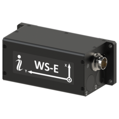
The WS-E (enhanced) and WS-PD (Professional Dual) are cutting-edge strapdown sensors that accurately capture wave dynamics, including heave, sway, surge, pitch, and roll data for unmanned Surface Vehicles (USVs) and other marine platforms.
These sensors can connect with external GNSS receivers, gyro compasses, and Doppler Velocity Logs (DVL), providing comprehensive spectral data through Fourier coefficients and energy outputs.
Wave Sensor Use Cases
- Oceanographic monitoring on buoys, USVs, and Autonomous Underwater Vehicles (AUVs)
For additional information, check out our Wave Sensors page.
Railway Motion Control Unit (RMCU)
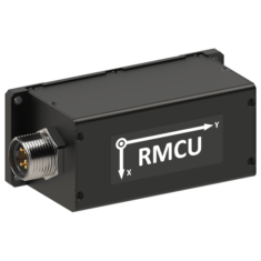
The RMCU is a complex strapdown system designed to ascertain absolute orientation (heading, pitch, roll) and motion parameters (angular rates and linear acceleration) for railway systems in both static and dynamic conditions.
This system adheres to EN 45545, EN 50155, and EN 50011 railway standards, incorporating advanced embedded algorithms tailored for various railway applications.
RMCU Applications
- Railway crack detection and analysis
- Enhancing safety and reliability in railway components
- Providing data for robust railway navigation systems
For more details, visit our RMCU page.
RESEPI – Remote Sensing Payload Instrument
Versatile LiDAR Point Cloud Generation for UAVs
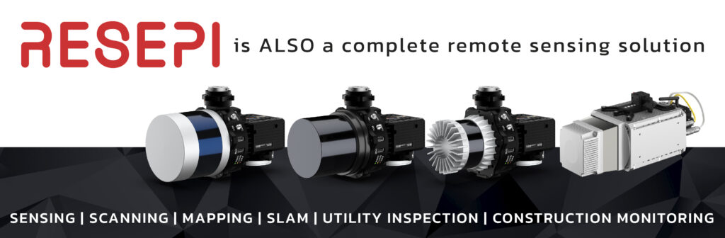
The RESEPI series offers high-precision LiDAR solutions for generating point clouds, designed for Inertial Labs partners and resellers to customize with their branding, allowing them to focus on their core strengths without the burden of additional development.
Built on a Linux-based processing platform,these modular systems feature Inertial Labs’ high-performance GPS-aided inertial navigation systems (INS) with advanced RTK/PPK GNSS receivers,Wi-Fi connectivity,and an embedded cellular modem for in-flight RTCM RTK corrections.
The RESEPI range includes two product lines: the original LITE models and the GEN II line, which offers enhanced onboard computing capabilities and seamless integration with MAVLink and DJI Payload SDK.
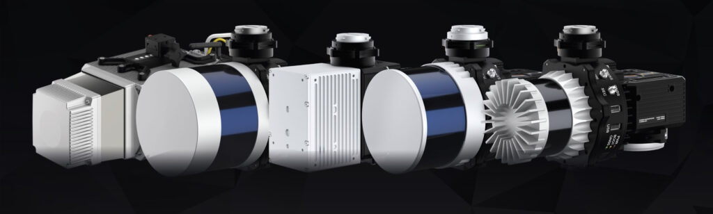
Thanks to Inertial labs’ state-of-the-art orientation and positioning technology, RESEPI generates exceptionally thin point clouds even at significant altitudes.The software suite includes fully automated RTK LAS file generation and a user-pleasant command line interface for post-processing.
The RESEPI product line is perfect for a variety of UAV remote sensing applications, such as:
- Mapping and Scanning
- Precision Agriculture
- Simultaneous Localization and Mapping (SLAM) Development
- Infrastructure and Utility Inspections
- Construction Site Monitoring
For further information, visit our RESEPI page.


