
As uncrewed surface vessels (USVs) venture into diverse operational domains, thay face increasing navigation challenges. This article delves into how FarSounder’s 3D Forward-Looking Sonar (FLS) technology enhances situational awareness for these vessels, addressing charting deficiencies to promote safer and more autonomous maritime operations.
Understanding 3D Forward-Looking Sonar Technology
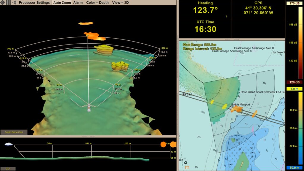
The Argos series of sonars from farsounder are widely recognized as advanced 3D Forward-Looking Sonars, utilized across various vessel types globally. Originally intended for mid-sized crewed ships, these Argos 3D FLS systems have been operational on uncrewed vessels since 2021.
Currently, these systems are deployed on numerous defense and civilian usvs that are 14 meters or longer. depending on the specific model, Argos 3D FLS can detect objects at distances ranging from 350 meters (over 1,100 feet) to 1,000 meters (more than half a nautical mile) ahead of the vessel.
The Argos series offers real-time navigational insights, creates bathymetric maps as vessels navigate different regions, and allows for anonymous data sharing across the FarSounder network, contributing to initiatives like Seabed 2030. The sonar data is accessible through both machine interfaces for automated systems and graphical displays for human operators.
Additionally, the FarSounder team is working on new hardware tailored for USVs under 14 meters in length, focusing on lower power consumption, a compact design, and cost reduction. These innovations aim to broaden the accessibility of 3D FLS technology across a wider array of uncrewed vessels, enhancing navigation safety throughout the industry.
The Expanding Role of USVs
The rise of autonomy and uncrewed vehicle (UxV) systems is becoming increasingly evident across various sectors and vehicle types.The swift evolution and integration of drone technology within the maritime industry continue to gain momentum. Factors such as enhanced broadband connectivity at sea, AI-driven control systems, a diminishing pool of skilled mariners, and the successful deployment of uncrewed systems in conflict zones like Ukraine have created meaningful opportunities for Autonomous/Uncrewed Surface Vessel (ASV/USV) platforms.
With the effectiveness of USVs established as force multipliers, the industry is now ready for broader applications beyond defense. Areas such as hydrographic surveying, search and rescue operations, environmental monitoring, and even cargo and passenger transport are becoming increasingly feasible. However, as these applications grow, a crucial question arises: what lies beneath the surface ahead of the vessel?
Similar to crewed vessels, the standard method for assessing underwater navigation hazards remains the electronic nautical chart (ENC). utilizing ENC data to plot routes that avoid shallow waters and submerged obstacles is relatively straightforward.
However,this approach has a significant flaw: it presumes that the underlying hydrographic survey data is extensive. While this may hold true for major shipping lanes and well-mapped regions, globally, only about 50% of coastal waters have been surveyed using modern techniques. As USVs operate in more remote coastal areas, relying solely on nautical charts is inadequate for safe navigation.
Comparing Above-Water Sensors and 3D Forward-Looking Sonars
in the early stages of USV growth, the focus was primarily on above-water sensors such as GPS, AIS, radar, and optical/thermal imaging, ensuring compliance with US Coast Guard regulations and COLREGS. Initial tests were conducted in well-mapped or deep-water regions, minimizing concerns about underwater hazards and downplaying the limitations of ENCs.
However, as asvs and USVs navigate into more complex environments, these assumptions no longer apply. Due to limited resources at hydrographic offices worldwide,comprehensive mapping efforts remain incomplete. Even within US territorial waters, only about 52% have been fully charted.
The Seabed 2030 initiative, a collaborative effort between GEBCO and the Nippon Foundation, supported by the IHO and endorsed by the UN, aims to create a global map of the seafloor. Yet, despite crowdsourced data and contributions from private survey operators, the initiative’s dataset currently covers only around 26% of the ocean floor at a maximum resolution of 100 meters.
For conventional crewed vessels, local knowledge and experienced crews help mitigate the limitations of charts in shallow waters. In contrast,USVs lack these human insights,resulting in gaps in situational awareness. Moreover, nautical charts cannot account for temporary obstacles, changes in the seafloor due to seasonal events or natural disasters, or operations in GPS-denied environments.
These challenges are especially significant in commercial, military, and scientific operations in the Arctic, where environmental changes are rapid, and in conflict zones where GPS jamming and spoofing are prevalent.
Above-water sensors alone cannot detect submerged hazards such as uncharted rock formations or coral reefs. they also fail to identify debris obstructing previously navigable channels after storms or the submerged portions of icebergs. Moreover, their ability to detect marine life, such as whales, is limited as these creatures frequently enough remain below the surface.
Preventing collisions with whales is crucial not only for vessel safety but also for the protection of marine mammals, as ship strikes are a leading cause of mortality for large whale species, including the critically endangered North Atlantic Right Whale.
ASVs and USVs are not restricted to above-water sensors.The integration of 3D Forward-Looking Sonar provides an essential underwater viewpoint.Introduced to the commercial maritime sector in 2005, 3D FLS is a well-established technology that addresses manny limitations associated with above-water sensors.
When combined with traditional navigation tools, 3D FLS allows vehicle control systems and remote operators to develop a more comprehensive understanding of their surroundings, identifying uncharted seafloor features, shifting sandbars, and transient objects.


