accomplished Sea Trials of the V-BAT UAS by Kongsberg Geospatial
Kongsberg Geospatial has recently completed successful sea trials for the Shield AI V-BAT Unmanned Aerial System (UAS) on behalf of the canadian Coast Guard. These trials took place aboard a small cargo vessel operating in international waters.
Exploring New Surveillance Capabilities
The Canadian Coast Guard is evaluating the long-endurance Vertical Take-Off and Landing (VTOL) UAS as part of a project funded by Defence Research and Development Canada (DRDC). this initiative aims to assess the potential integration of the V-BAT system on Canadian Coast Guard vessels.
Why the V-BAT Was Chosen
The Shield AI V-BAT was selected for its unique ability to perform VTOL operations in confined spaces while also offering the endurance typical of fixed-wing aircraft. This versatility allows it to carry multiple sensors effectively.
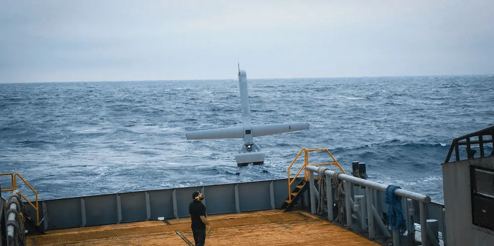
Details of the Sea Trials
In collaboration with Shield AI, Kongsberg Geospatial conducted a three-day sea trial in the Gulf of Mexico. The trials focused on the V-BAT’s capabilities for rapid launch and recovery, long operational endurance, and its ability to take off and land from a moving vessel under various weather conditions, both during the day and at night.
Simulated missions and Real-World Applications
During the flights, the V-BAT was tasked with tracking and identifying distant vessels. Additionally,it executed simulated missions that mirrored real-life scenarios faced by the Canadian Coast Guard,such as locating dye patches that represented wreckage or oil spills and finding life preservers in rough seas.
Advanced Software for Enhanced Operations
The V-BAT operators utilized Kongsberg Geospatial’s IRIS UxS software to pilot the aircraft over long distances from the launch vessel. This software provides a detailed situational awareness of the airspace, integrating data from various sensors and feeds, and displaying the positions of other aircraft, surface vessels, and the drone itself.
Data Management and Analysis
Real-time sensor data from the UAS’s cameras and other equipment were processed through the Kongsberg Geospatial Modular ISR Data Analysis and storage system (MIDAS). This system not onyl records video and data from the UAS but also acts as a mission intelligence coordinator, allowing for the analysis of current and past sensor feeds in both temporal and geospatial contexts to enhance sensor effectiveness.
Feedback from the Trials
“Even though the sea conditions were a bit rougher than anticipated, they provided an excellent opportunity to test the V-BAT’s launch and recovery capabilities under realistic operational conditions,” stated Rex Hayes, a retired US Navy and Coast Guard officer and the Director of Unmanned Systems at kongsberg Geospatial. “We were also impressed with how well the IRIS and MIDAS systems managed integrated sensor data during extended missions.”
Commitment to Global Partnerships
Brandon Tseng, co-founder of Shield AI and a former US Navy SEAL, emphasized the importance of collaboration: “Supporting our allies is crucial.Strong partnerships—technological,military,and economic—are essential for maintaining stability in challenging times. Sharing technologies like the V-BAT not only strengthens strategic relationships but also contributes to global stability. Our recent collaboration with the Canadian Coast guard and Kongsberg highlights our dedication to providing our allies with cutting-edge technology.”


