
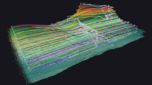
YellowScan illustrates how GeoAerospace utilized the Yellowscan Surveyor Ultra LiDAR system to gather LiDAR data across forestry locations, facilitating the creation of terrain models for hydrological studies.
Overview of the Challenge
After a fruitful collaboration with a governmental body, GeoAerospace secured a contract to conduct airborne LiDAR data collection in various forestry regions along Ireland’s remote west coast.
The main aim was to gather high-resolution airborne LiDAR data, essential for mapping isolated mountainous areas as part of forestry management initiatives. This data is critical for developing precise terrain models for hydrological evaluations, which aid in identifying and quantifying river channels hidden beneath thick vegetation.
Due to the unique characteristics of the terrain, accessing these sites with traditional survey aircraft posed considerable challenges. the extensive areas and the rugged, isolated mountainous landscape rendered ground-based surveys unfeasible.
Innovative Solutions Implemented
Considering these challenges, GeoAerospace was tasked with collecting LiDAR data across multiple locations using their YellowScan Surveyor Ultra. The objective was to create terrain models and evaluate the hydrological features at each site.to navigate the complexities of the habitat and adverse weather conditions, drone surveys employing automated terrain-following technology were deployed at select locations. This method ensured precise and consistent data collection and analysis, even under difficult circumstances.
As part of their strategic vision, GeoAerospace aims to enhance client value through the data they gather. They effectively leveraged the vegetation penetration capabilities of LiDAR and its multi-echo functionality to meticulously map vegetation layers, integrating this information into forestry inventory processes, thereby providing an additional service to their clients.
This initiative successfully streamlined workflows for generating tree maps, allowing for extensive forestry inventory assessments across thousands of individual trees. Key metrics such as tree height and crown spread were accurately recorded, yielding valuable insights for effective forestry management.
Flight plan covering approximately 300 hectares (750 acres)
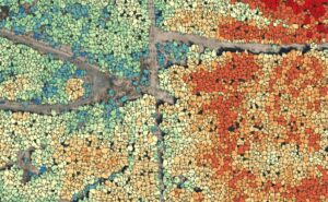
Tree Map detailing tree height and crown diameter for thousands of individual trees.
survey Parameters
- Survey Area: Multiple sites, each approximately 300 hectares (750 acres)
- Duration:
- 1-2 days for flight planning (per site) due to complex access and landowner permissions
- 1-2 days on-site (per site) due to mobilization and access challenges for maintaining line-of-sight operations
- Flight count: Approximately 8 flights of 20 minutes each per site
- Flight Speed and Altitude: 70m AGL (terrain-following via UGCS) at 10m/s
- Equipment: Yellowscan Surveyor Ultra LiDAR system
- Drone Model: DJI M300
- Trajectory Correction: PPK using CORS station managed by Ordinance Survey Ireland
outcomes Achieved
- Point Density: Over 200 points per meter
- Accuracy: 5cm
- Digital Surface Model & Digital Terrain Model (5cm GSD)
The aerial LiDAR data provided invaluable insights that would have been difficult to obtain through other methods, given the large size and remote, densely forested nature of the sites.This data was collected efficiently and within a timely framework.
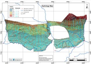
Hydrology Map illustrating elevation in relation to stream typology.
In addition to the standard point cloud, contours, DSM (Digital surface Model), and DTM (Digital terrain Model), GeoAerospace was able to deliver customized outputs derived from the LiDAR data. These included a range of additional maps such as slope, aspect, elevation, and hydrology.
The high-resolution LiDAR data and dense point clouds facilitated a comprehensive analysis of the terrain beneath the canopy, leading to accurate hydrological evaluations of the landscape. Compared to traditional ground-based surveys, this approach significantly reduced acquisition time, costs, and on-site duration.
Due to the necessity of flying their survey aircraft at 500m (1500ft), within the operational range of the aircraft’s LiDAR, and the challenges of navigating mountainous terrain, it was deemed unsafe to fly into the valleys.
Fortunately, GeoAerospace noted that access to high-quality drone-based LiDAR data enabled them to provide data of comparable accuracy and standards, but with a higher point density. They emphasized the remarkable efficiency of their YellowScan LiDAR solution and CloudStation in delivering data that meets the high expectations of their clients.
They also pointed out that,while specific support was not requested for this project,YellowScan consistently offers prompt,efficient,and high-quality assistance.
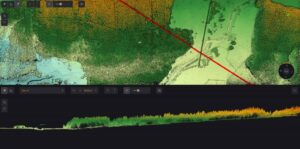
Cross-section through forestry.
“The sites posed numerous challenges regarding access to high mountainous valleys for our survey aircraft, necessitating automated terrain-following drone surveys at certain locations due to the complex terrain and adverse weather conditions. Access to high-quality drone-based LiDAR data allowed us to deliver data of equal standard and accuracy with greater point density. The rapid deployment of our yellowscan LiDAR system often surpasses that of our survey aircraft, which is crucial in time-sensitive survey scenarios,” stated Fearghus Foyle, Managing Director of GeoAerospace.


