Innovative Drone Detection Solutions by DeTect and UST
DeTect, a prominent innovator in the realm of UAV (unmanned aerial vehicle) detection and defense systems, has joined forces with Unmanned Systems Technology (UST) to showcase their cutting-edge capabilities. Their ‘Silver’ profile emphasizes the request of refined radar and remote sensing technologies for security, surveillance, and long-range monitoring of BVLOS (Beyond Visual Line of Sight) drone operations.
The DroneWatcher system is a comprehensive UAV detection and defense solution that integrates three advanced technologies, allowing for self-reliant use or a combined approach to create a customizable drone tracking and interception platform.
DroneWatcherApp: A Cutting-Edge Mobile Solution
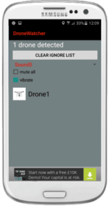
The DroneWatcherApp is an advanced application designed for Android devices, capable of detecting and tracking around 95% of consumer and prosumer drones available today. It is offered in free,Pro,and Pro Premium versions.
This app can log various details, including drone type and identification, with an operational range extending up to half a mile. It serves as a valuable tool for documenting unauthorized drone activities,aiding law enforcement in apprehending and prosecuting offenders.

DroneWatcherRF enhances the capabilities of the DroneWatcherApp with a compact, standalone unit that can be easily installed at facility perimeters, requiring minimal power and network connectivity.
With an extended detection range of up to 2 miles and a continuously updated database of drone RF signatures, DroneWatcherRF is an optimal solution for high-security environments.
HARRIER DSR: Advanced Military-Grade Detection
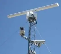
The HARRIER DSR (drone surveillance radar) introduces a sophisticated military-grade solid-state Doppler radar as an additional layer to the DroneWatcher system. This technology enables detection of drones over 2 miles away, even in environments with complex clutter and without relying on RF or GPS signals.
HARRIER DSR is capable of identifying and tracking not only small consumer drones but also military UAVs, both cooperative and non-cooperative. It can be integrated with various ancillary sensors, including video systems and third-party interception technologies, enhancing its operational versatility.
DeTect’s HARRIER radars are specifically engineered for the detection and tracking of small targets with minimal radar cross-section and erratic movement patterns, making them ideal for safeguarding against rogue drones, manned aircraft, and marine vessels.
These radars offer comprehensive surveillance capabilities from ground level to over 20,000 feet AGL, effectively detecting and tracking both aerial and marine targets in cluttered environments. Automatic drone identification and intrusion alerts provide real-time situational awareness regarding potential non-cooperative UAS threats.
HARRIER S200: Ground-Based Sense-and-Avoid Technology
The HARRIER S200 Ground-based Sense-and-Avoid (GBSAA) system leverages detect’s proven HARRIER Air Surveillance Radar technology to facilitate long-range airspace monitoring, supporting extended BVLOS operations for UAVs. The HARRIER S200 is available in both fixed and mobile configurations, allowing for customization to fit various vehicles, buildings, and towers.
This system utilizes solid-state Doppler S- or X-band radar, capable of detecting both transponder-equipped cooperative UAS and non-cooperative manned and unmanned aircraft up to 20 miles away. It supports Secondary Traffic Advisory System (TAS) and Automatic Dependent Surveillance–Broadcast (ADS-B), with user-defined risk alert zones and intrusion perimeters.
For more details about DeTect and their innovative drone detection and monitoring systems tailored for defense and BVLOS sense-and-avoid applications, please visit their profile page:
DeTect Profile


