This article delves into the distinctions, applications, adn benefits of lidar and photogrammetric point clouds, as discussed by Amanda Lind from Blue Marble Geographics in Global Mapper.
while lidar point clouds and those generated through photogrammetry may appear similar in global Mapper Pro, they possess unique characteristics that set them apart.
Both types can be classified, features can be extracted, and they are fully compatible with the extensive lidar toolset. Though, without examining their attributes, differentiating between them can be challenging.Understanding the strengths and weaknesses of each data type can enhance your ability to leverage your data effectively within Global Mapper.
Photogrammetry can produce precise and cost-effective high-resolution point clouds.
Lidar Technology
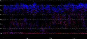
The initial returns (blue) indicate the tops of trees, while other returns are mixed, with the last return reflecting light from the ground.
Lidar is often regarded as the more precise technique for terrain measurement. Unlike photogrammetry, lidar can penetrate through vegetation, revealing the ground beneath and providing a more comprehensive view of the landscape. The lidar sensor emits light beams towards the surface and measures the time taken for the light to return, calculating distance. Occasionally, the light beam may split, with part returning to the sensor while the remainder continues to another surface, resulting in multiple returns from a single beam. These return counts are recorded as attributes for further analysis.
This capability makes lidar particularly effective for generating digital terrain models in areas with dense vegetation or when dealing with smaller, less visible objects or structures.
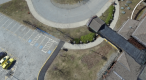
Lidar technology can identify the ground beneath vegetation and other structures that can be penetrated. This data was collected by the Latvian State Forest Research Institute “Silava.”
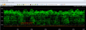
The image below illustrates classified lidar data, showcasing how ground points remain visible even in heavily forested regions.
Photogrammetric Point Clouds Explained
In contrast to lidar’s direct measurement approach, photogrammetry employs an indirect method, deriving locational and elevation data (XYZ) through triangulation from overlapping aerial images.For a deeper understanding of how Global Mapper’s Pixels to Points tool utilizes photogrammetry to generate points from imagery, click here. A key limitation of photogrammetry is its reliance on visibility; it can only map what is captured in the images. For instance, in densely forested areas, the canopy may obstruct the camera’s view of the ground, preventing the creation of ground points.
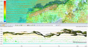
Comparison of a photogrammetric point cloud (colored by imagery) with a lidar point cloud (colored by elevation).Lidar successfully penetrated the forest canopy, while photogrammetry only captured the upper layer.
Photogrammetry offers advantages in terms of data collection simplicity. Despite advancements in portable lidar technology, drone imagery remains a more cost-effective and widely used method for data acquisition. This accessibility allows users to frequently measure areas, gathering timely data. In Global Mapper, this capability can be utilized to monitor changes in terrain over time, such as erosion or habitat fragmentation. The compare Point Clouds tool enables users to assess differences or detect changes between point clouds. While this is also applicable to lidar point clouds,photogrammetric point clouds can be collected more frequently.
another benefit of photogrammetric point clouds is their inherent color information (RGB values) derived from the imagery. This feature enhances visual interpretation and classification, resulting in a more aesthetically pleasing product.Although colors can be manually added to lidar data from images, they may not accurately represent the actual ground color at the time of lidar collection.
As technology progresses, it is anticipated that drone-mounted and color-compatible lidar sensors will become more affordable and accessible.however, for the time being, photogrammetry effectively addresses this data gap.
Both types of point clouds serve as valuable tools for mapping terrain and surface data, irrespective of the intended application. When utilized together, they can provide a comprehensive view of the landscape. By understanding the differences between the two, you can maximize the potential of your data and achieve superior results. To explore more about processing lidar and drone-collected data in Global Mapper Pro, consider downloading a free 14-day trial.


