In collaboration with YellowScan,a leader in LiDAR mapping technology,DeltaQuad has successfully integrated a colorized LiDAR solution into its latest Evo UAV model.
DeltaQuad proudly claims that the Evo is the frist fixed-wing Vertical Take-Off and Landing (VTOL) UAV globally to feature a combined YellowScan LiDAR and RGB system.
The partnership aims to revolutionize mapping capabilities by merging the YellowScan technology with the DeltaQuad Evo, providing georeferenced colorized LiDAR data with exceptional terrain coverage.
At present,advanced quadcopters can support combined LiDAR and RGB systems,achieving flight durations of up to 30 minutes and covering approximately 100 hectares. Meanwhile, some fixed-wing VTOLs can manage LiDAR systems that span up to 400 hectares but lack integrated RGB sensors, necessitating repeated flight paths to gather RGB data. The DeltaQuad Evo sets a new benchmark with an impressive flight time of 2.5 hours, capable of surveying up to 500 hectares in a single flight using the YellowScan LiDAR and RGB system.
With a remarkable density of up to 200 data points per square meter,the YellowScan system delivers highly precise and detailed terrain data. The data processing is streamlined through YellowScan CloudStation software, which enhances the efficiency of extensive mapping projects.
Moreover,the inclusion of an RGB sensor allows for the colorization of georeferenced LiDAR points,significantly improving usability and facilitating the identification of complex features.
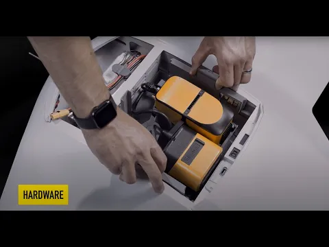
the DeltaQuad Evo’s modular design empowers users to create a versatile sensor ecosystem. Its global payload bay can accommodate payloads weighing up to 3 kg, allowing for the simultaneous use of two different sensors during a single flight (such as RGB, Multispectral, Thermal, ISR, or any custom sensor). Alternatively, one sensor can be replaced with an auxiliary battery, extending flight time to as much as 4.5 hours. The open design of the payload bay ensures compatibility with future sensor innovations, while the ‘Click & Go’ mechanism with automated payload recognition simplifies the process of swapping payloads without the need for tools.
Tristan Allouis,co-founder and CEO of YellowScan,expressed enthusiasm about the collaboration,stating,“Partnering with DeltaQuad is an exciting journey as we work together to develop innovative solutions for challenging applications. Our mutual commitment guarantees the provision of highly efficient and dependable solutions for our esteemed clients.”
Douwe Zeeman, CEO of DeltaQuad, highlighted this development as a prime example of customer-focused co-creation. He takes pride in enhancing the DeltaQuad Evo with features that promote more effective data collection in the mapping sector.


