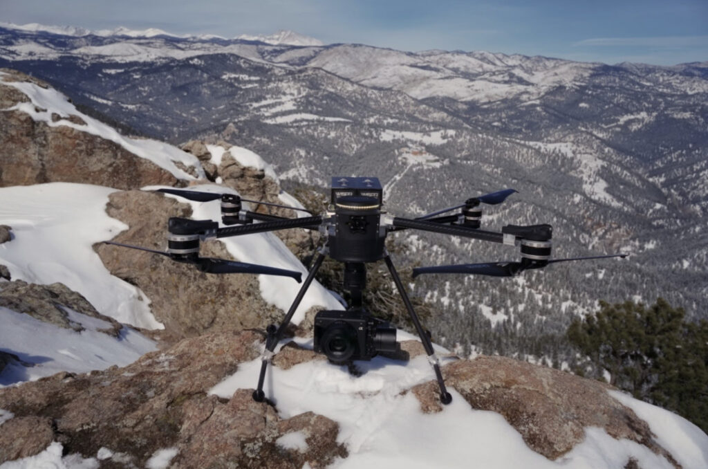
WISPR SkyScout paired with Sony ILX-LR1.
As the landscape of aerial data acquisition advances, industries are increasingly in search of dependable tools to enhance both efficiency and precision. In response, WISPR Systems has introduced skyscout, a drone platform specifically designed for a variety of applications such as photogrammetry, LiDAR, mapping, surveying, and inspection. Discover more >>
SkyScout is engineered for tasks that involve capturing high-resolution images for 3D modeling, performing land surveys, and inspecting critical infrastructure, all while prioritizing the delivery of accurate data and reliable performance.
Photogrammetry: Capturing Images for 3D Models
Photogrammetry utilizes drones capable of gathering geo-referenced, high-resolution images that are clear enough for processing. SkyScout is equipped with features that enhance this capability, including camera setups with mechanical shutters that minimize image distortion. It’s advanced GPS system guarantees precise geotagging, which is essential for creating trustworthy models and maps.
Moreover, SkyScout’s remarkable flight endurance allows it to survey larger areas in a single mission, while its automated geotagging of images streamlines data management and integration into existing workflows. These features empower surveyors and engineers to efficiently produce 3D models, orthomosaic maps, and digital elevation models (DEMs), all while reducing overlap and processing time.
LiDAR: detailed Terrain Mapping
LiDAR (Light Detection and Ranging) is a crucial tool for topographic mapping, forestry assessments, and infrastructure planning.SkyScout is designed to accommodate and integrate with LiDAR sensors, enabling the collection of bare-earth terrain data by penetrating through vegetation. It can create dense point clouds with extraordinary detail, providing data that is ideal for accurate measurements.
Additionally, SkyScout facilitates precise volume calculations, which are particularly beneficial in sectors like construction and mining. Its stability and payload capacity ensure that LiDAR systems function smoothly and reliably, even in challenging environmental conditions.
Mapping and Surveying: Efficient Data Collection
Successful large-area mapping and surveying require drones that can sustain long flights and carry the necessary equipment. SkyScout fulfills these criteria with automated flight planning that includes terrain-following capabilities, allowing it to adjust to varying landscapes during missions. Its RTK (Real-Time Kinematic) and PPK (Post-Processing Kinematic) positioning systems deliver high-accuracy measurements that cater to detailed mapping and surveying requirements.
Moreover,SkyScout’s extended flight times enable it to cover more ground in fewer missions,enhancing workflows in site planning,land growth,agricultural monitoring,and environmental assessments.
Inspection: High-Resolution Infrastructure Monitoring
Infrastructure inspections often require detailed, close-range data, especially in locations that are hazardous or difficult for personnel to access. SkyScout supports:
- Asset inspections for power lines, wind turbines, bridges, and pipelines
- Thermal and multispectral imaging to detect defects
- Live video streaming for real-time monitoring
Utilizing drones for these inspections can significantly reduce the need for manual assessments, potentially decreasing downtime and enhancing worker safety in industries such as utilities and telecommunications.
Key Features of SkyScout
SkyScout is equipped with a range of functional features,including:
- Modular payload options for diverse applications
- Extended flight endurance for prolonged operations
- Robust construction suitable for field conditions
- Software integration for efficient data management and processing
SkyScout stands out as a versatile drone platform capable of handling photogrammetry,lidar mapping,and inspection tasks,offering a comprehensive suite of tools for data collection and analysis across various professional sectors.
Explore the original article >>


