
Advanced Navigation has unveiled a groundbreaking solution that significantly enhances long-term resilience against threats like GPS jamming adn spoofing.
This innovative system integrates a strategic-grade fiber-optic gyroscope (FOG) inertial navigation system (INS) with a novel navigation aid known as a Laser Velocity Sensor (LVS). The software-fused inertial architecture guarantees exceptional precision and reliability, eliminating the dependency on GNSS, and according to Advanced Navigation, it establishes a new benchmark for autonomy in drones and robotics.
A Revolutionary Approach to Navigation Resilience
At the core of any dependable navigation system lies a reliable source of truth: the INS. Advanced Navigation’s FOG INS is sensitive enough to detect the Earth’s rotation, providing a solid foundation for accurate attitude determination. In tandem, the LVS employs infrared lasers to measure a vehicle’s ground-relative 3D velocity with remarkable accuracy and long-term stability. Unlike conventional sensors,the LVS operates effectively on both terrestrial and aerial platforms,provided it maintains a clear line of sight to the ground or a stationary object.
Along with serving as a velocity aid, the LVS bolsters navigation resilience by identifying GNSS spoofing attempts. By cross-referencing its self-reliant velocity data with GNSS-derived velocity, the LVS enhances the security of Assured Positioning, Navigation, and Timing (APNT) strategies.
Advanced Data Fusion for Enhanced Performance
The AdNav OS Fusion utilizes advanced algorithms to analyze and filter sensor data. this software dynamically adjusts the weight of each sensor’s input in real-time, based on reliability scores, environmental factors, and operational context. This ensures continuous, high-confidence state estimation, even when signals are lost, degraded, or distorted. This multi-sensor, inertial-centered approach marks a significant improvement in navigation performance in GNSS-denied environments compared to conventional methods.
Real-World Validation of Hybrid System capabilities
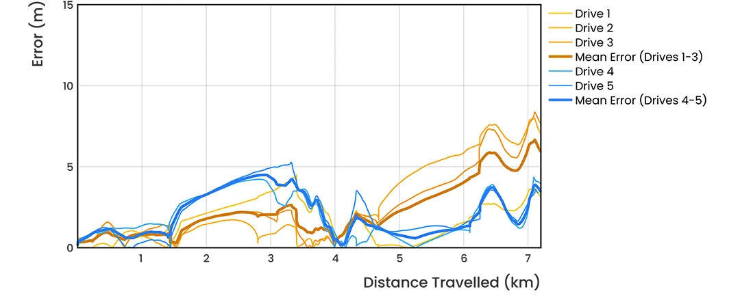
to assess the accuracy and resilience of the LVS Hybrid system, Advanced Navigation executed a series of rigorous real-world driving tests. Over five trials, the system achieved outstanding performance, with an average error of just 0.053% per distance traveled when compared to a GNSS reference.
Initially, GNSS on the INS was disabled during the state estimation process, compelling the system to operate in dead-reckoning mode. RTK GNSS data was recorded separately for reference, allowing for a direct comparison between the computed dead-reckoning solution and a trusted position reference.
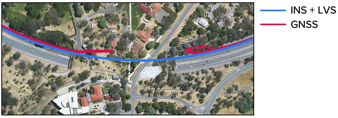
The data below illustrates the dead-reckoning results from a 23 km drive around Canberra, Australia, where GNSS was not utilized for heading or position at any point. The RTK GNSS is represented by the red line,while the results from the Hybrid system are shown in blue.
Similarly, the results from a 19.2 km drive around the Parliamentary Triangle in Canberra are depicted, again with no GNSS used for heading or position. The RTK GNSS is shown in red, while the Hybrid system’s results are in blue.
The following figure zooms in on a section from the first test drive, illustrating the GNSS (red) dropout as the test vehicle traversed a tunnel, which completely obstructed the GNSS reference measurement.The Hybrid system’s results, shown in blue, indicate it did not experience this error.
These tests were conducted multiple times, consistently yielding reliable results.
The Hybrid system was also evaluated on a fixed-wing aircraft paired with a tactical-grade INS, achieving a final error of 0.045% over a low-altitude flight spanning 545 km.These results underscore the system’s remarkable capability to enhance INS navigation performance in GNSS-denied or contested environments. For a deeper exploration of the technology, a white paper is available here.
Bridging Space Technology to Earth Applications
The LVS represents a terrestrial adaptation of LUNA (Laser Unit for Navigation Aid), a space-grade navigation technology designed for autonomous lunar landings. LUNA facilitates reliable navigation in the challenging conditions of space by providing precise three-dimensional velocity and altitude data relative to the Moon’s surface. After several years of research and advancement, LUNA is set to be demonstrated aboard Intuitive Machines’ Nova-C lander as part of NASA’s Commercial Lunar Payload Services (CLPS) initiative.
By applying the engineering insights gained from LUNA, LVS transforms space technology into an Earth-ready solution for GNSS-denied navigation.
The Future of Navigation: A New Paradigm
In the rapidly evolving operational landscape, reliance on a single sensor technology (such as GNSS or IMU) is increasingly inadequate. Missions are often conducted in GNSS-denied, electromagnetically noisy, and physically complex environments where traditional systems struggle.
Effective navigation necessitates a layered, inertial-first, multi-sensor architecture—integrated by smart software—that can adapt and scale to meet the specific demands of each mission. With a software-defined approach, Advanced navigation’s architecture allows for updates and enhancements to be implemented with minimal hardware disruption. This shift ensures truly resilient navigation for critical applications across defense, aerospace, robotics, and autonomous systems.
Chris Shaw, CEO and co-founder of Advanced Navigation, remarked: “The world is changing, and navigation must change with it. GPS is alarmingly susceptible to challenging environments, severe weather, and cyber threats, with increasing risks of jamming and spoofing. The question is not if GPS will fail, but when. Operators must build resilience now.”
“This hybrid solution is crafted with adaptability and reliability at its core. While others focus on individual components, Advanced Navigation promotes a layered, inertial-centered, multi-sensor architecture, seamlessly integrated by intelligent software. This approach can be updated or modified to meet the demands of harsh environments and mission requirements.”
Advanced navigation is currently showcasing its innovations at the XPONENTIAL 2025 trade show in Houston – visit them at booth 1915.


