
DeTect Advances Offshore Wind Energy Research with MERLIN True3D Radar
DeTect, Inc.,a prominent innovator in unmanned aerial vehicle (UAV) and drone detection technologies,is broadening its radar technology applications to enhance offshore wind energy research.
Expertise in UAV Detection
Renowned for its cutting-edge tracking radar and remote sensing solutions within the unmanned systems industry, DeTect has established a strong reputation for delivering effective monitoring, defense, and tracking systems for UAVs.
The company specializes in drone detection radars,which are utilized worldwide for security and surveillance purposes. These systems play a crucial role in the long-range monitoring of Ground-Based Detect and Avoid (GBDAA) operations, notably for Beyond Visual Line of Sight (BVLOS) drone activities.
Innovative Dual-Function Radar System
Among its notable developments is the MERLIN True3D BDR-DDR, a versatile radar system designed for both counter-UAS and avian management, serving to protect commercial airports and military airfields.
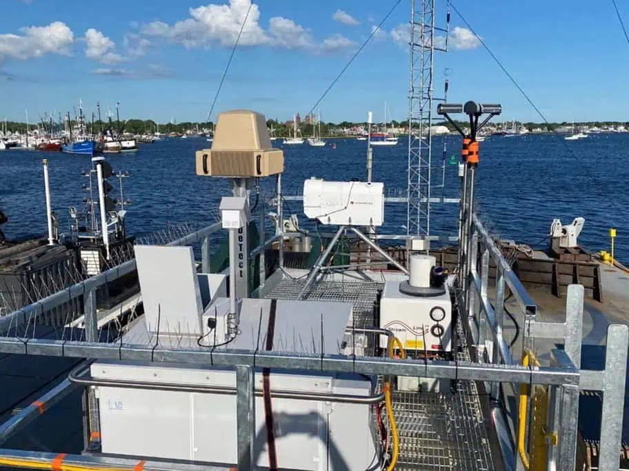
Adapting technology for Environmental Research
Building on its established expertise,DeTect has now adapted the MERLIN True3D Radar for use in offshore wind energy research. This initiative highlights the adaptability of UAV detection technology in tackling meaningful environmental issues.
Collaboration on the Wind Forecast improvement Project
the radar system has been tailored for the Wind Forecast Improvement Project (WFIP3), a collaborative effort involving the U.S. Department of Energy, National Oceanic and Atmospheric Governance, Woods Hole Oceanographic Institution, and Pacific Northwest National Laboratory. This 18-month project aims to collect vital meteorological, oceanographic, and biological data in proximity to offshore wind farms located in the Northeast United States.
Advanced Data Collection Capabilities
engineered to navigate the complexities of tracking avian and bat movements while compensating for the challenges of operating on a moving platform, the radar system is equipped with an electronic stabilization mechanism. This feature adjusts the collected tracking data in real-time to account for variations in heading, roll, pitch, and yaw.
with a comprehensive 360-degree coverage and track updates occurring four times per second, the system gathers essential positional and altitudinal data on airborne targets. This information is invaluable for understanding bird and bat migration rates, as well as wildlife movement patterns and their respective altitudes.
Integration and deployment Options
Designed for deployment on offshore vessels and buoys,the radar system can be integrated with radar-directed electro-optic and infrared (EOIR) camera systems. It is available in both fixed and mobile configurations, enhancing its versatility.
Impact on Wind Energy and Wildlife Conservation
The insights gained from the data collected are anticipated to play a significant role in optimizing the design and operation of offshore wind turbines and wind farms, striking a balance between energy production and wildlife conservation efforts.


