Enhanced Mission Planning for Deep Trekker ROVs
Deep Trekker has introduced advanced mission planning capabilities within the software of its handheld controllers designed for underwater ROVs (remotely operated vehicles). Owners of the Deep Trekker Revolution and Pivot models can now upgrade their software to include features that allow for waypoint plotting and saving.
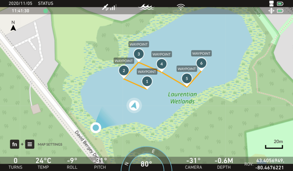
Streamlining Navigation for ROV Pilots
This new mission planning functionality is a significant advancement towards achieving greater autonomy in ROV operations. It simplifies navigation for pilots, providing them with an intuitive tool to improve their operational efficiency. Users can plot waypoints directly on the handheld controller’s map, and visualize the trajectory connecting these points.
Comprehensive Site Visualization
With the entire mission displayed on their screens,pilots can effectively gauge the dimensions of their inspection areas,ensuring thorough evaluations. The on-screen waypoint map allows for a clear understanding of the ROV’s position within the inspection site. High-quality graphics enhance the pilot’s navigation experience, making it easier to maneuver the vehicle accurately.
Interactive Waypoint Management
The waypoint system within the software comprises precise latitude and longitude coordinates, offering essential data for mission planning. Pilots can interact with these waypoints using joystick controls, enabling them to name, edit, or delete points as needed.
convenient Mission Review and Analysis
Users have the option to save their missions for future reference, facilitating easy analysis and review. During the review process, they can perform various tasks, such as examining maps and mission paths, as well as accessing and modifying CSV files for detailed data management.


