Global Mapper Pro by Blue Marble.
Introduction to Global Mapper v26.1
Blue Marble Geographics has launched Global Mapper® v26.1, the latest winter update that introduces highly anticipated features such as customizable presets, enhancements in point cloud processing, and advancements in deep learning technology.
Comprehensive GIS Solution
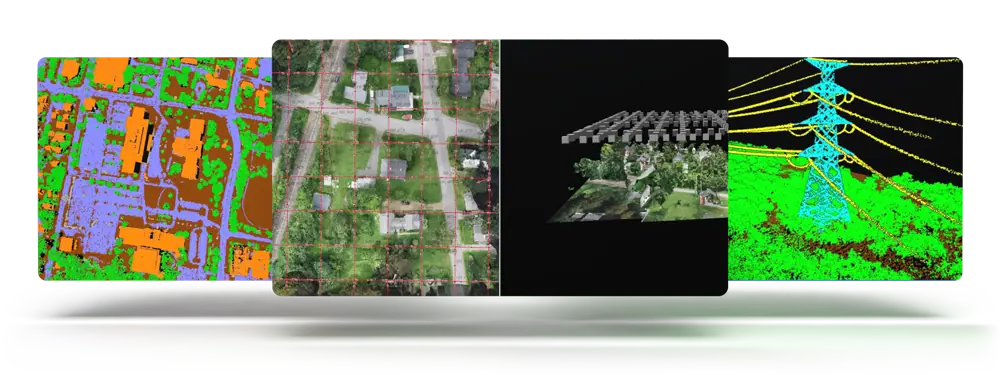
global Mapper serves as a versatile GIS software platform, crafted with user accessibility and feedback at its core. the standard edition offers basic tools for vector, raster, and terrain analysis, making it suitable for a diverse array of users. For those requiring more complex geospatial functionalities, Global Mapper Pro® builds upon these capabilities with advanced features like photogrammetry, terrain painting, and lidar analysis, which includes automatic cloud classification and feature extraction, as well as Python scripting.

User-Centric Enhancements
The latest version of Global Mapper emphasizes user experience and personalization. The Digitizer toolbar has been streamlined, consolidating buttons into a dedicated toolset. Similarly, Global Mapper Pro features an enhanced toolset for Manual Classification of Point Clouds, improving user interaction.
A newly introduced scripting toolbar allows for straightforward access to script creation and editing tools, along with a Favorite Scripts option for quick execution of both Global Mapper and Python scripts. Other usability enhancements include the ability to explicitly set camera positions in the 3D Viewer and save text file import settings for future use.
Advanced Learning Tools
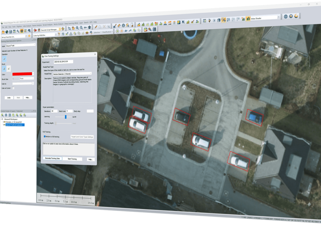
Global Mapper Pro version 26.1 continues to offer access to the Insight and Learning engine (beta), a sophisticated toolset aimed at improving user learning experiences. This engine incorporates the latest AI models from Blue Marble Geographics, enabling users to fine-tune and retrain their own models for specific applications. A dedicated configuration set simplifies model management and sharing, fostering collaboration and enhancing workflow efficiency.
Point Cloud Data Management Improvements
Version 26.1 introduces important enhancements in point cloud data management, including segmentation-based classification for identifying powerlines and an expanded Split Layers tool that divides point clouds into layers based on attributes like classification, point source ID, or return number.
Enhanced Point Cloud Analysis
Users will find improved options in the Lidar QC tool for eliminating outlier control points following initial comparisons. Additionally,enhancements in Pixels to Points® drone/UAV image analysis now include color harmonization features.
Educational Resources
For those interested in mastering global Mapper Pro’s photogrammetry processing capabilities, Blue Marble Geographics has introduced a new Pixels to Points course in their Online Classroom. This self-paced course covers essential features, including ground control points, uploading drone imagery, generating point clouds and orthoimages, and classifying ground points to create elevation grids.
Conclusion
Product Manager Jeff Hatzel remarked,“The innovations in Global Mapper Pro push the boundaries of technology further. This latest update features exciting enhancements to our AI-driven tools, including expanded machine learning-based point cloud classification methods for powerlines. Moreover, we have refined the Insight and Learning Engine’s deep learning image analysis tools to include vehicle detection fine-tuning and custom model sharing.”


