Innovative Bathymetric Survey Techniques by Hydro-Tech
Hydro-Tech has published a thorough research document detailing their methodology for conducting a bathymetric survey of the foundational stone in the Yellow River.Discover more >>
Advanced survey Equipment
The firm utilized the low-SWaP MS400U multibeam echosounder, specifically engineered for integration with compact unmanned surface vessels (USVs). This device employs a sound velocity profiler alongside 512 acoustic beams to effectively survey the riverbanks.
Survey Objectives and Methodology
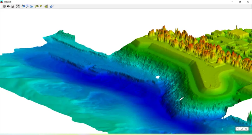
This initiative aimed to provide a thorough examination of both the above-water and underwater topography of the embankment located on the northern bank of an inland waterway. The MS400U was instrumental in capturing the underwater features through its multi-beam surveying capabilities.
Mapping Underwater Terrain
The primary goal of this research was to generate a detailed three-dimensional map of the underwater landscape surrounding the embankment. This mapping is crucial for assessing the condition of the base stone and monitoring erosion levels along the embankment.
Key Findings and Insights
The research paper delves into several critical aspects, including:
- Survey Prerequisites — initial inspections, troubleshooting, data processing, and additional requirements.
- Data Interpretation — findings, modeling, accuracy assessments, and more.
- Comprehensive Data Visualization
Hydro-tech concluded that it is feasible to collect survey data capable of producing complete three-dimensional terrain maps, encompassing both the above-water and underwater sections of the river.
Explore the in-depth results or visit the Hydro-Tech website for further details.


