
SBG SYSTEMS stands out as a premier provider of MEMS-based, ITAR-free inertial motion sensing technologies. Their range includes compact inertial navigation systems and high-precision INS GPS solutions, delivering an exceptional combination of affordability, size, and performance tailored for unmanned systems navigation.
SBG Systems presents a extensive array of inertial sensors utilizing cutting-edge MEMS technology, including Attitude and Heading reference Systems (AHRS), Inertial Measurement Units (IMU), and integrated GPS Inertial Navigation systems (INS/GPS).With advanced calibration methods and complex embedded algorithms, these sensors are perfectly suited for applications in unmanned vehicle control, antenna tracking, camera stabilization, and surveying.
Navigate to Section:
- Micro – IMU, AHRS, INS
- Miniature – IMU, AHRS, INS
- Tactical-Grade IMU
- Mid/High Accuracy (INS)
- INS/GNSS Post-Processing Software
Micro Inertial Navigation Systems
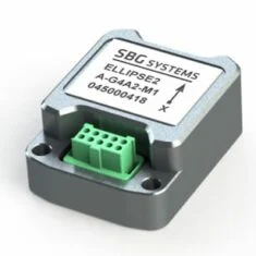
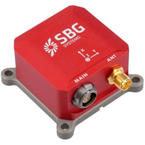
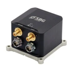
Ellipse Micro Series – IMU & AHRS
Compact, High-Performance IMU and AHRS for Unmanned Applications

These industrial-grade micro inertial sensors boast high accuracy (0.1° Roll/Pitch) and the smallest form factor:
- Weighing only 10 grams
- High-end gyroscopes and accelerometers designed for industrial use
- Extended calibration range from -40 to +85°C for consistent performance across diverse environments
- Integration with GNSS receivers for reliable position, heave, and heading outputs
- Specialized motion algorithms optimized for land systems like UGVs and autonomous vehicles
- Cost-effective design aimed at large-scale projects.
|
|
|
|
| Ellipse Micro IMU | Ellipse Micro AHRS | |
| Calibrated IMU data | ✔️ | ✔️ |
| Roll,Pitch,Heading | X | ✔️ |
| Heave | X | ✔️ |
| Navigation | X | X |
More Information: Ellipse Micro Series
Miniature Inertial Navigation Systems
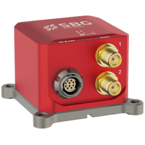
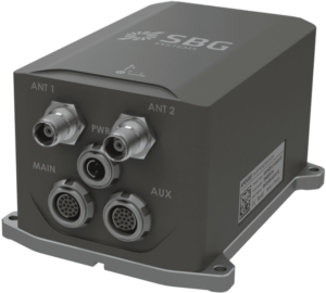
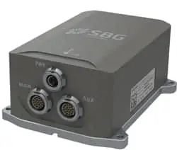
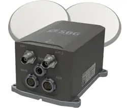
Ellipse Series – Industrial-Grade Inertial Sensors
Durable,high-performance inertial sensors for compact unmanned systems
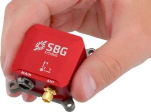
The third generation of ITAR-free miniature inertial sensors features a robust design, advanced sensors, and sophisticated algorithms:
- 0.05° RMS accuracy
- Ultra-Low Noise Gyroscopes
- Embedded 64-bit microprocessor
- Integrated GPS + GLONASS/BEIDOU receiver
- Supports DGPS corrections and Odometer inputs
- Advanced algorithms for handling vibrations and magnetic disturbances.
|
|
|
|
|
|
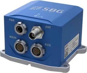
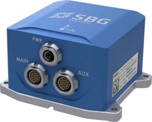
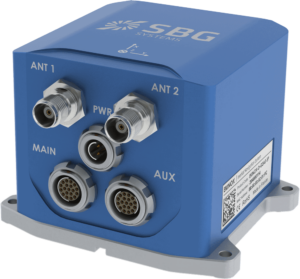
| Ellipse-A Orientation + Heave Motion Sensor | Ellipse-E INS with your own external GNSS receiver | Ellipse-N Single Antenna RTK INS with integrated GNSS receiver | Ellipse-D Dual Antenna RTK INS with integrated GNSS receiver | |
| Roll and Pitch | 0.1° over 360° | 0.05° RTK | 0.05° RTK | 0.05° RTK |
| Heading | 0.8° Heading (Internal Magnetometers) | Magnetic or GNSS Heading | 0.2° Heading (RTK high dynamics) | 0.2° Heading (Dual Antenna RTK GNSS) |
| Heave | 5 cm Real-time Heave | 5 cm Real-time Heave | 5 cm Real-time Heave | 5 cm Real-time Heave |
| Navigation | X | Navigation with external GNSS receiver | L1/L2 GNSS receiver 1 cm RTK GNSS Accuracy | L1/L2 GNSS receiver 1 cm RTK GNSS Accuracy |
| Post-Processing | X | ✔️ | ✔️ | ✔️ |
More Information: Ellipse Miniature Inertial Navigation Systems
quanta UAV Series
Precision INS/GNSS for UAV Surveying Applications
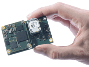
The Quanta series represents a high-precision GNSS-aided Inertial Navigation System tailored for UAV and terrestrial surveying tasks.
- Lightweight and energy-efficient
- Utilizes an Extended Kalman Filter to integrate inertial and GNSS data for optimal performance in challenging environments
- Real-time geotagging of point clouds enhances accuracy during post-processing
- Direct georeferencing reduces the need for ground control points and minimizes overlap
- Also serves as a premium navigation solution for UAV autopilots.
More Information: Quanta UAV Series INS/GNSS
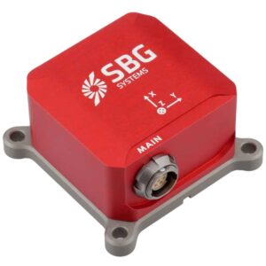
Tactical-grade IMU
Pulse-40
Compact tactical-grade 6 DoF IMU for UAVs and unmanned systems

The Pulse-40 is a tactical-grade inertial measurement unit engineered for high-precision stabilization and navigation, even in extreme conditions. It features advanced MEMS three-axis accelerometers and gyroscopes in a unique redundant design, ensuring minimal Vibration Rectification Error (VRE), making it ideal for high-frequency dynamics and high-vibration scenarios.
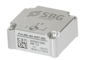
Weighing just 12 grams and consuming only 0.3W,the Pulse-40’s compact size and low power requirements make it suitable for various drones and robotic platforms. The unit includes redundant sensor integration and continuous Built-In-Test, ensuring maximum data reliability for critical applications.
Key Features:
- Optimal SWaP-C: 12 grams, 0.3W Power consumption
- Ultra-Low Noise Gyro (0.08°/√h) and excellent Gyro Bias Instability (0.8°/h)
- High-precision Accelerometers (6µg)
- Low Vibration Rectification Error: MIL-STD 810 qualified for shocks and vibrations
- High Bandwidth (480Hz) and High data rate (2KHz)
- Thoroughly tested and calibrated from -40°C to 85°C
- No export restrictions apply
More Information: Pulse-40 Tactical-Grade IMU
Mid Accuracy Small INS
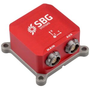
Ekinox Series
Mid Accuracy AHRS and INS/GNSS for High-performance Unmanned Systems
This mid-accuracy system (0.02° attitude) is designed to be cost-effective and compact:
- Combines Odometer, GNSS, and DVL for optimal accuracy
- Internal L1/L2 Survey-grade GNSS receiver
- Low latency and high output rate for demanding applications
- Post-processing capabilities for surveying tasks
- Motion profiles tailored for the specific dynamics of UAVs, UGVs, and UUVs
|
|
|
|
|
|
| Model | Ekinox-A | Ekinox-E | Ekinox-D | Ekinox-Micro |
| Roll, pitch, Heading | ✔️ | ✔️ | ✔️ | ✔️ |
| Heave | ✔️ | ✔️ | ✔️ | ✔️ |
| Navigation | X | ✔️ Connection to external GPS | ✔️ Integrated dual-antenna GNSS receiver | ✔️ Integrated dual-antenna GNSS receiver |
More Information: Ekinox Inertial Navigation System
High Accuracy INS
Apogee Series
High-precision AHRS and INS/GNSS for Survey Unmanned Systems
This system offers the highest accuracy (0.005° orientation) in a compact, cost-effective INS package:
- Combines Odometer, GNSS, and DVL for optimal accuracy
- internal L1/L2/L5 Survey-grade GNSS receiver
- Low latency and high output rate for demanding applications
- Post-processing software for surveying tasks
- Motion profiles tailored for UAVs, UGVs, and UUVs specific dynamics
|
|
|
|
|
| Apogee-A | Apogee-E | Apogee-D | |
| Roll, Pitch, Heading | ✔️ | ✔️ | ✔️ |
| Heave | ✔️ | ✔️ | ✔️ |
| Navigation | X | ✔️ Connection to external GPS, odometer, etc. | ✔️ Integrated dual-antenna GNSS receiver |

More Information: Apogee High Performance INS
Post-Processing Software
Qinertia
INS/GNSS Post-Processing Software
Qinertia is our advanced GNSS/INS post-processing software, providing access to offline, continuously updated RTK corrections from over 7,000 base stations across 164 countries.
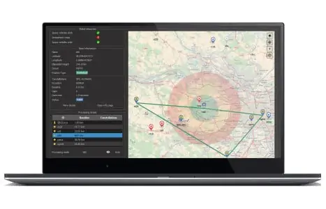
This software supports all GNSS receivers and third-party IMUs, featuring a proprietary tight coupling algorithm designed to deliver maximum accuracy and enhance RTK availability.
qinertia also includes Virtual Base Station (VBS) functionality, creating a virtual network around your project to provide centimeter-level accuracy, even in corridor mapping, remote locations, and areas with limited RTK coverage.
Qinertia is available in four distinct tiers:
- Qinertia Pro – a comprehensive GNSS/INS post-processing solution supporting all SBG sensors and third-party IMUs
- Qinertia Lite – a budget-friendly option for UAV and land-based projects, compatible with all SBG sensors
- Qinertia UAV – tailored for UAV-based surveying and photogrammetry tasks
- Qinertia GNSS – focused on static and kinematic GNSS data processing, compatible with any receiver
More Information: Qinertia INS/GNSS Post-Processing Software

SBG Systems’ Support Center
We are excited to introduce our new platform designed to simplify your integration process.the Support Center is your go-to resource for all information related to SBG inertial sensors, including getting started guides, user manuals, firmware updates, FAQs, and tutorials.
Explore the Knowledge area to learn more about inertial and GNSS technologies!


