
Collaboration Between Kongsberg Geospatial and Pegasus Imagery Ltd to Enhance UAS Safety
Kongsberg Geospatial has partnered with Pegasus Imagery Ltd through a Memorandum of Understanding (MoU) aimed at enhancing the safety and efficiency of Unmanned Aerial Systems (UAS).
Integration of Advanced Navigation Systems
pegasus will incorporate Kongsberg Geospatial’s IRIS UxS airspace situational awareness system into it’s BVLOS (Beyond Visual Line-of-Sight) flight operations, specifically within its PV-02 Eos autonomous aircraft framework.
Expanding Operational Capabilities
engaging in BVLOS operations,Pegasus offers services such as photogrammetry,LiDAR,and enhanced Full-Motion Video (FMV) surveys for both governmental and industrial sectors. their missions encompass a variety of tasks, from inspecting power transmission lines to monitoring forest fire activities.
“Kongsberg has a rich legacy of providing mission-ready solutions like IRIS UxS, which significantly enhance airspace management in challenging conditions,” stated Cole Rosentreter, CEO of Pegasus Imagery. “By integrating these advanced capabilities with our aircraft and onboard Detect-and-Avoid (DAA) systems, we will significantly improve safety and situational awareness for routine operations in shared airspace.”
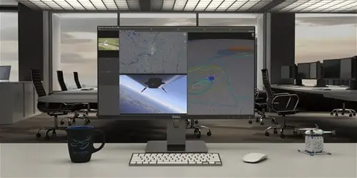
Real-Time Airspace Management
The IRIS airspace visualization technology from Kongsberg Geospatial allows a single remote operator to monitor multiple drones and sensor feeds simultaneously. It provides real-time calculations for aircraft separation and communication, facilitating BVLOS operations.
Utilizing Kongsberg Geospatial’s leading TerraLens SDK, IRIS offers elegant 2D and 3D visualizations of airborne tracks and whether data, along with alerts and warnings that empower a single operator to navigate complex airspace environments effectively.
Proven applications in Various Sectors
Kongsberg’s IRIS UxS has been successfully implemented in diverse BVLOS flight operations,including drone delivery services and inspections of oil and gas infrastructure.
“We are excited to collaborate with an innovative leader like Pegasus,” remarked Ranald McGillis, President of Kongsberg geospatial. “Our teams have worked closely to seamlessly integrate our technology with their PV-02 Eos platform.”
Innovative UAS Solutions for ISR
Pegasus specializes in designing, manufacturing, and operating autonomous UAS to provide scalable Intelligence, Surveillance, and Reconnaissance (ISR) solutions for both industry and government. Their aircraft, equipped with proprietary Detect-and-Avoid sensor systems, can safely operate in shared airspace alongside manned and unmanned aircraft, delivering on-demand data solutions.
Among Pegasus’ technological advancements is the Autonomous Airspace Awareness System (A3S), a Detect-and-Avoid sensor system that employs airborne radar and other sensors to autonomously navigate around potential hazards such as birds, other drones, and manned aircraft. Additionally, they have developed the Moisture & icing Detection Alert System (MIDAS), which alerts pilots to icing conditions, and the PV-02 Eos, their proprietary autonomous aircraft.


