
Applanix has joined forces with aerialtronics,a complete solution provider that leverages drones,AI,and IoT data to deliver enhanced and actionable insights,creating a seamless integration of aerial technology into everyday business practices.Discover more >>
With over a decade of experience, Aerialtronics has been at the forefront of drone technology for various professional sectors, including surveying, agriculture, inspections, and mapping. Plowman Craven, a prominent surveying firm, sought the expertise of aerialtronics and Applanix for a UAV-driven survey solution tailored for railways.
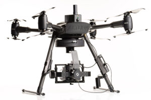
Drone Platform: Altura Zenith
The Altura Zenith commercial drone, developed by Aerialtronics, features a robust battery that allows for flight durations of up to 40 minutes. It is equipped with eight motors for redundancy, supports a wide range of payloads, and offers user-pleasant “click and go” operations, making it adaptable for various applications.
Advantages
Achieve centimeter-level accuracy in significantly less time compared to conventional methods.
-
eliminates the need for Ground Control points (GCPs)
-
No requirement to access railway tracks
-
Enhanced safety measures
-
Facilitates regular assessments of rail track conditions
-
Lowers maintenance expenses
-
Boosts reliability
-
Compact, user-friendly, and cost-efficient solution
-
Capable of generating 3D mapping outputs
-
increased efficiency — optimized workflows allow for rapid product generation
A unified solution with Applanix DG for Aerial Surveys
Aerialtronics can customize integrated payloads and solutions tailored to each client’s unique needs.
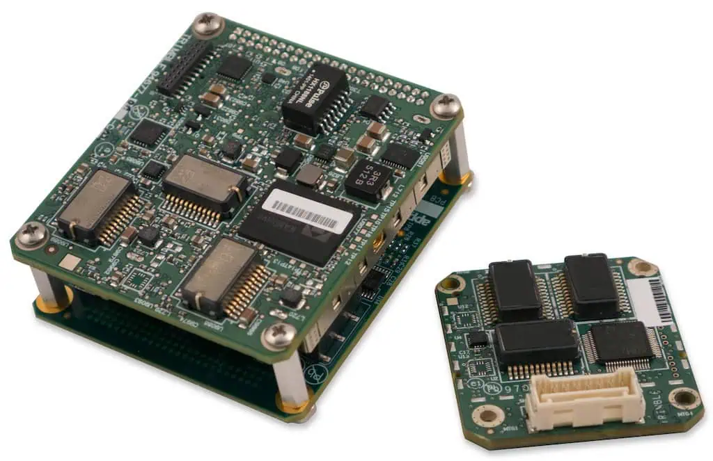
One notable integration involves the Trimble APX-15 EI and POSPac UAV GNSS-Inertial post-processing software. The APX-15 EI is a compact system that includes a high-precision GNSS receiver and dual inertial measurement units, one embedded in the GNSS/Inertial board and another as a remote external unit.
This configuration allows the APX-15 EI to provide automatic support to the Zenith gimbaled platform. Coupled with the POSPac UAV software, it enables geolocation of pixels at centimeter to millimeter precision without the need for GCPs, while minimizing the required sidelap, thus maximizing the area covered per mission.
Applications of Applanix DG Solutions
Daily, Applanix DG technology is utilized to gather the most precise UAV data from various sensors, including multispectral, hyperspectral, radar, LiDAR, and RGB cameras. This technology supports a wide array of mapping products without relying on ground control.
UAV applications include:
-
Topographic Surveys
-
3D Mapping
-
Utility Inspections
-
Asset Management
-
Agricultural Monitoring
The Applanix DG serves as the foundational technology for Corridor Mapping (single flight line), Large Area Mapping, multi-flight missions, or BVLOS operations.
Challenges Faced
Conventional rail surveys frequently enough incur high costs due to necessary rail closures and the hazardous access to busy railways. For years, Plowman Craven has been a leader in providing rail survey data. They sought a more efficient solution that would:
-
Minimize risks associated with accessing rail tracks
-
Lower costs and time related to ground control points
-
Facilitate rapid data collection
-
Ensure high accuracy

Introducing the Vogel R3D by Plowman Craven for Rail Infrastructure Surveys
Plowman Craven offers integrated measurement and consultancy services across property and infrastructure sectors. By pioneering technical advancements, they deliver reliable expertise and results throughout project lifecycles, playing a vital role in prestigious construction and redevelopment projects both in the UK and internationally.
In search of a tailored solution, Plowman Craven collaborated with Aerialtronics. The resulting system features the Aerialtronics Altura Zenith ATX8 drone, integrated with the APX-15 EI, POSPac UAV software, and a Phase One iXM100 camera with an 80mm lens, collectively known as the Vogel R3D.
Tom Wren, technical Consultant – Infrastructure Services at Plowman Craven, stated:
“The Vogel R3D transforms rail survey and inspection processes. It eliminates the need for physical track access, along with the associated costs and time.”
“Rapid data acquisition, superior accuracy compared to traditional laser scanning systems, and sub-5mm precision suitable for detailed track design make the Vogel R3D an appealing option with diverse applications. Additionally, the high-definition imagery we capture significantly enhances current survey deliverables.”
Outcomes
Plowman craven’s Vogel R3D solution is a groundbreaking UAV-based system capable of conducting thorough drone surveys of rail infrastructure with sub-5mm accuracy in a fraction of the time required by traditional methods. This innovative system captures overlapping aerial images of entire sites.
These images can be transformed into 3D point cloud data, facilitating the creation of various deliverables, including track alignments, detailed topographic surveys, 3D BIM models, and interactive site visualizations. The Vogel R3D has been successfully tested by Network Rail, with accuracy results validated, and has been employed in over 70 active projects.
The financial implications of closing an operational railway for maintenance or inspection can be ample, often costing thousands and requiring extensive planning. This integrated solution offers significant savings in both costs and project timelines.
For the original article, or to explore the Trimble applanix website, click here.


