WISPR Systems designs and manufactures advanced drone platforms for commercial and industrial applications. One of the company’s key technologies is Real-Time Kinematic (RTK) positioning, integrated into the WISPR SkyScout drone system to deliver highly accurate aerial data.
 In environments where precision is critical, such as construction, land surveying, infrastructure inspection, and agriculture, RTK ensures data consistency and reduces the need for rework caused by GPS inaccuracies. This article outlines how RTK functions within the WISPR SkyScout system and provides a step-by-step breakdown of the workflow, highlighting its impact across a range of industries.
What Is RTK?
Real-Time Kinematic (RTK) positioning is a GPS correction method that enhances accuracy by using reference data from a base station or correction network. While standard GPS typically offers accuracy within 1–3 meters, RTK reduces this margin to 2–5 centimeters in real time. This level of precision allows users to produce dependable geospatial outputs with minimal reliance on ground control points (GCPs).
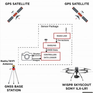
RTK Functionality in the WISPR SkyScout System
During RTK-enabled flights, the WISPR SkyScout communicates continuously with GNSS satellites and a local base station or network correction service. This real-time communication allows each image and data point to be precisely geo-referenced without manual input or extensive field setup.
The system integrates flight control, positioning, and image capture into a unified workflow, producing survey-grade results directly from flight operations.
Step-by-Step RTK Workflow
1. Pre-Flight: RTK Setup: RTK corrections can be supplied via a physical GNSS base station or a correction service using NTRIP (Networked Transport of RTCM via Internet Protocol). Operators may place a base station on a known coordinate point or connect to a network correction service via a cellular connection.
The SkyScout platform supports both options. Once the initial configuration is complete, typically with assistance from WISPR’s team when needed, setup consists of powering on the system and establishing the correction link through the controller or ground station.
2. Mission Planning: With the RTK link active, operators use WISPR Ground Control to plan the flight. Mission parameters such as grid spacing, altitude, image overlap, and capture settings are defined within the software.
It is essential to verify that the RTK connection is active, indicated by ‘RTK FIX’ next to the satellite icon in the top right og WISPR Ground Control, to ensure that all data is captured with centimeter-level accuracy.
3. Flight Operations: Once the mission begins, the SkyScout executes the pre-planned flight path while maintaining real-time RTK communication. Each image and waypoint is geo-tagged with high-precision coordinates, significantly reducing or eliminating the need for GCPs.
For projects requiring validation against survey-grade standards, a limited number of GCPs may still be incorporated to enhance absolute accuracy.
4. Post-Flight Processing: Images captured by the SkyScout are automatically geo-referenced during flight and saved to the onboard SD card. The data can be transferred directly into any processing software such as Pix4D, gNext Labs, Carlson Point Cloud, or Trimble Business Center without additional conversion steps.
The integrated RTK system supports a wide range of mapping and modeling applications. For workflows requiring post-processed data, the SkyScout also supports PPK (Post-Processed Kinematic) processing.
Note: The SkyScout supports PPK without requiring additional hardware; processing is handled through WISPR’s optional cloud-based software, available by subscription, to further enhance positional accuracy when required.
Applications Where RTK Provides Maximum Value
RTK is particularly beneficial in operational environments that demand high positional accuracy and where manual methods are time-consuming or impractical. Key applications include:
- Surveying and Mapping: Generate precise topographic maps and boundary surveys with minimal field intervention.
- Construction Monitoring: Track progress and site changes with high temporal and spatial accuracy.
- Volume Measurement: Calculate stockpiles and material shifts with reliable repeatability.
- Utilities and Infrastructure: Perform detailed inspections of power lines, substations, and similar assets using geo-referenced imagery.
- Agricultural Monitoring: Evaluate crop health and field conditions with location-specific consistency.
- Oil and Gas Surveys: Conduct detailed mapping of facilities, pipelines, and pads for inspection and compliance purposes.
- Structural and Bridge Assessment: Capture 3D visual models for engineering analysis without disrupting operations.
RTK for Drone Operators
Although RTK is a sophisticated positioning method, the WISPR SkyScout system is designed to streamline its implementation. The platform minimizes manual setup requirements and simplifies the overall workflow, making high-precision aerial data accessible to operators without specialized surveying backgrounds.
By automating data correction and reducing fieldwork, RTK enables more efficient project execution, especially on large or remote sites, and supports the delivery of accurate, dependable results across a wide range of professional applications.
Read the original article >>


