Kongsberg Geospatial is a leading developer of mission-critical software applications that provide mapping capabilities, geospatial data visualization, and situational awareness for UAVs (unmanned aerial vehicles) and uncrewed systems.

Our high-performance geospatial solutions enable the next generation of civilian and military BVLOS (beyond visual line of sight) drone missions, and also provide UTM (unmanned traffic management) and airspace awareness for integrating UAVs into civilian airspace.
IRIS Terminal
Enterprise airspace visualization for BVLOS UAS operators
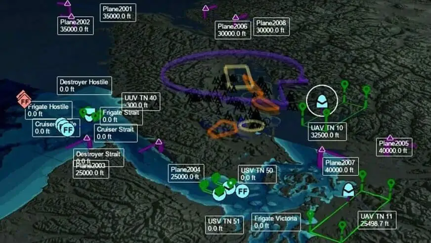
IRIS Terminal is a real-time airspace visualization platform for enterprise UAS operators or UAS test sites operating BVLOS. Utilizing real-time cooperative and non-cooperative data sources such as ADS-B, RADAR, EOIR sensors, TASA sensors, AIS sensors and ownship telemetry, IRIS Terminal provides a true airspace picture of the operating theater in one ‘plane of glass’.

Simultaneously our collision avoidance service computes the projected flight path of all detected aircraft, correlates duplicate tracks and alerts the operator in case of potential airspace conflict or loss of separation. An optional web-based component (IRIS Webviewer) allows operators to share real-time updates and tracks with team members in the field on their LTE enabled tablet.
More information: IRIS Terminal
IRIS GCS
Ground control software for BVLOS UAS fleets
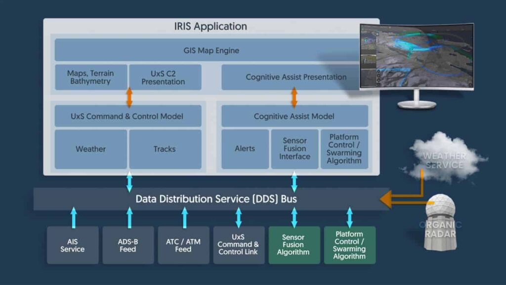
 IRIS GCS is a full-featured ground control station software package that delivers enhanced real-time situational awareness for UAVs operating beyond visual line of sight (BVLOS), and is also ideal for USVs (unmanned surface vessels) and UUVs (unmanned underwater vessels).
Providing the ability to track multiple vehicles in real time, IRIS GCS integrates 2D and 3D map and terrain data, aeronautical information, data from sensors, cameras and drone telemetry, as well as ATM/UTM (air/unmanned traffic management) data feeds.
More information: IRIS GCS
TerraLens
Geospatial software development kit
 TerraLens is a powerful software development kit (SDK) that allows users to easily create real-time 2D and 3D GIS (geographic information system) mapping and geospatial data visualization applications. The software allows developers to layer map data with multiple sources of geospatial data, including real-time data feeds, databases, maps and images.
Providing the most important features and capabilities without the need to develop a new display framework from scratch, TerraLens allows applications to be deployed to a wide variety of platforms, operating systems, and form factors.
More information: TerraLens – Geospatial Data Visualization Platform

