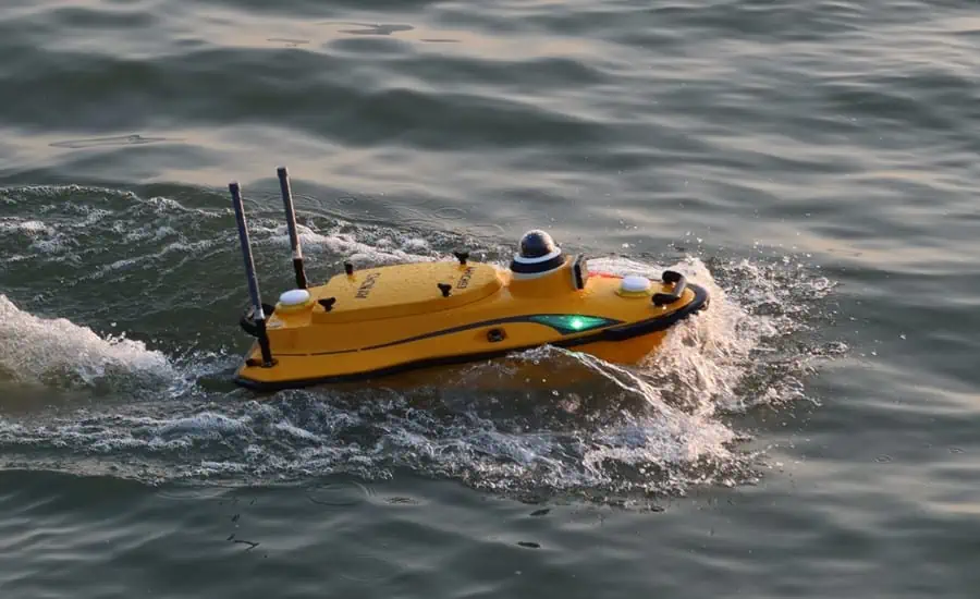
CHC Navigation (CHCNAV) has launched the Apache 3 Pro, a compact hydrographic uncrewed surface vessel (USV) designed for autonomous bathymetric surveys in shallow waters. Featuring a lightweight carbon fiber hull with IP67-rated ingress protection and semi-recessed motor, the Apache 3 Pro offers exceptional durability and maneuverability.
Featuring CHCNAV’s proprietary GNSS RTK + inertial navigation sensor, the Apache 3 Pro provides consistent, high-precision positioning and heading data even when navigating under bridges or in areas with obstructed satellite signals. The built-in CHCNAV D270 echosounder enables reliable depth measurement from 0.2 to 40 meters. The Apache 3 Pro is also equipped with a millimeter-wave radar system that detects obstacles within a wide 110° field of view. When an obstacle is encountered, the USV autonomously charts a new course to safely navigate around it.
Weighing only 10 kg, the Apache 3 Pro features a lightweight macromolecular polyester carbon fiber and Kevlar composite hull for exceptional resilience. Even with a fully integrated payload, the USV can be easily deployed and controlled by a single operator in a wide range of environmental conditions.
The Apache 3 Pro ensures reliable communications through its integrated SIM and network bridge with automatic switching. It also features seamless cloud-based remote monitoring that provides real-time status updates, enhancing control and security. Utilizing both 4G and 2.4GHz networks, the Apache 3 Pro eliminates range limitations and facilitates effective data transfer.
The Apache 3 Pro’s semi-recessed brushless internal rotor motors minimize drafts, improving the USV’s maneuverability in varying water depths. The advanced propulsion design also increases protection, reducing the likelihood of damage and extending motor life.
Taxiya Wang, Product Manager at CHC Navigation, commented: “The Apache 3 Pro sets a new standard for shallow water bathymetric surveys. Its lightweight rugged design, integrated navigation, and enhanced obstacle avoidance enable efficient, high-precision data collection even in challenging conditions. With the D270 echosounder and seamless data connectivity, the Apache 3 Pro delivers outstanding performance and efficiency in bathymetric surveying.”


