High-definition base maps are essential for enabling safe and efficient autonomous vehicle navigation, and Trimble Applanix is leading the charge in advancing the technologies that make them more accurate, reliable and cost-effective. Find out more > >
 By integrating next-generation Direct Georeferencing (DG) with advanced mobile mapping systems, Trimble is helping eliminate reliance on ground control points and reduce errors caused by challenging environments or multiple survey passes.
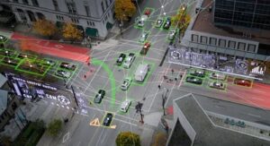
Enhanced DG solutions from Trimble pair high-performance GNSS corrections with mobile LiDAR and SLAM technologies to produce precise spatial data in real time. This robust combination supports autonomous applications in both outdoor and GNSS-denied environments, such as underground parking garages and rail yards, where traditional mapping solutions fall short.
Case studies from Railergy and NavInfo showcase how Trimble’s DG and mobile mapping systems reduce setup time and increase positional accuracy. Railergy successfully deployed Trimble’s Applanix POS LV to create a fully automated rail yard map without disrupting operations, while NavInfo used Applanix LiDAR QC Tools and GNSS-inertial integration to generate a high-accuracy HD map for an automated valet parking system.
These technologies do more than improve mapping accuracy, they streamline workflows, reduce labor costs and enhance safety by eliminating inconsistencies in data. Trimble’s DG solutions enable autonomous vehicles to interpret their surroundings with the precision required to make real-time decisions on roadways, at intersections and in complex environments.
By removing barriers to high-quality map production, Trimble is accelerating the deployment of autonomous systems across industries. Their commitment to innovation in DG and mobile mapping is paving the way for a more autonomous future.
Read the original article.
