News / Unlocking the Skies: UAV Navigation by Grupo Oesía /

Revolutionary High-Precision VTOL UAV LiDAR Scanning Solution Unveiled!

uav navigation logo.webp

Guidance, Navigation & Control Solutions (GNC) for Drones & UAVs

Revolutionary High-Precision VTOL UAV LiDAR Scanning Solution Unveiled!

Ventus-Tech Robotics' tailsitter VTOL UAV has been integrated with the Yellowscan Mapper+ OEM payload


Innovative High-Precision VTOL UAV LiDAR Scanning Technology

Revolutionizing Aerial Mapping wiht Cutting-Edge LiDAR Technology

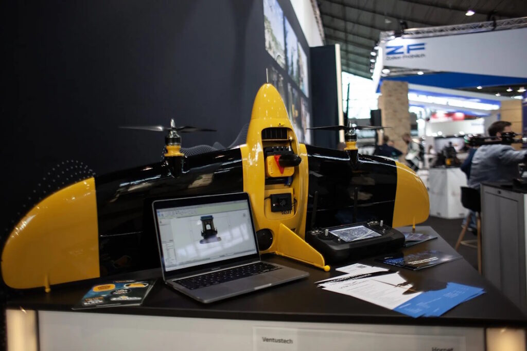
YellowScan, a leader in LiDAR technology for unmanned aerial vehicles, has joined forces with VTR (Ventus-Tech Robotics) Drones to unveil a state-of-the-art LiDAR scanning solution. This innovative system combines a refined payload with a pioneering tailsitter VTOL (Vertical Takeoff and Landing) drone design.

Unmatched Precision and Versatility

Crafted by a skilled team of UAV specialists, this LiDAR scanning solution delivers remarkable accuracy, efficiency, and adaptability for aerial surveying and mapping tasks. The VTR drone, weighing only 3950g including the LiDAR payload, exemplifies a perfect balance of strength and lightweight construction. Its robust yet agile frame guarantees exceptional performance and endurance, even in demanding conditions, making it suitable for sectors such as construction, forestry, agriculture, and environmental assessment.

Enhanced Capabilities with Yellowscan Mapper+

The incorporation of the yellowscan Mapper+ OEM payload substantially boosts the drone’s functionality, enabling precise, real-time 3D data acquisition with outstanding accuracy. The innovative tailsitter VTOL design facilitates a smooth transition from vertical takeoff to horizontal flight, maximizing operational efficiency and making it ideal for use in confined or rugged terrains where conventional UAVs may struggle.

Availability and Upcoming Showcase

This thorough solution is now ready for commercial deployment and will be featured at the 2025 INTERGEO trade exhibition in Frankfurt, Germany, from October 7-9, 2025.

uav navigation 2.webp
Guidance, Navigation & Control Solutions (GNC) for Drones & UAVs

Calle Teide 3, Oficina 0.1, 28703, San Sebastián de los Reyes, Madrid

Send Message

Supplier's Products

Unlocking Insights: The FDR01 Data Recorder
Flight data recorder for UAVs & unmanned systems
Unleash Your Potential with the VECTOR-SIL Simulator!
Software-in-the-loop UAV simulator for basic testing & training
Unlocking Potential: The Power of VECTOR-MCC Computer
Mission control computer enabling independent payload management
Unleashing Potential: The VECTOR-HIL Simulator Experience
Hardware-in-the-loop UAV training simulator
Unlocking Potential: Discover the Power of Visionair GCS Software
Ground control station software for mission planning & analysis
Unlocking Connectivity: The GHU-100 Ground Hub Unit
GCS hardware hub for multi-peripheral networking
Discover the Precision of the DGC01 GNSS Compass!
Dual GNSS compass for high-accuracy heading estimation
Discover the Precision of the DGC01 GNSS Compass!
Dual GNSS compass for high-accuracy heading estimation
Discover the Power of Precision: Unveiling the MG01 Magnetometer
Self-contained magnetometer for dynamic UAV applications
Discover the Future of Travel with the VNS01 Navigation System!
Visual navigation system for GNSS-denied environments
Unlocking Precision: The POLAR-300 AHRS-IMU Revolution
Combined air data, AHRS & INS unit for UAVs
Unlocking Precision: The POLAR-500 AHRS-IMU Revolution
AHRS-IMU system with dual GNSS compassing
Unlocking Navigation: The GNSS-Denied Navigation Kit
Combined AHRS and visual navigation for reliable dead reckoning
Discover the Power of Precision: Introducing the VECTOR-600 Autopilot
Advanced flight control computer for fixed-wing & VTOL UAVs
Discover the Future of Flight with VECTOR-400 Autopilot!
Mil-spec autopilot designed for aerial targets

More News from Unlocking the Skies: UAV Navigation by Grupo Oesía