
Advanced Navigation stands out as a premier producer of precision inertial navigation systems tailored for both commercial and defence sectors. Our navigation solutions, based on MEMS (micro electro-Mechanical Systems) and FOG (Fiber Optic Gyro) technologies, are perfectly suited for a variety of applications involving UAVs (unmanned aerial vehicles), UGVs (unmanned ground vehicles), and AUVs (autonomous underwater vehicles).
Utilizing our expertise in software-defined hardware, each product offers unparalleled performance and capabilities in environments where GPS signals may be unreliable, spanning land, air, sea, and space.
Our advancements stem from rigorous research, extensive testing, and a fully integrated manufacturing process, allowing us to delve into advanced technology sectors such as robotics, inertial navigation, photonic and quantum sensing, artificial intelligence, underwater acoustics, and GPS antennas and receivers.Clients choose Advanced Navigation for our swift product delivery and exceptional technical expertise.
Based in Sydney, Australia, with research and manufacturing facilities across the nation and international offices, Advanced Navigation is a proud Australian exporter.
Sections:
- Miniature MEMS AHRS
- Miniature MEMS IMU
- MEMS GNSS-INS
- FOG GNSS-INS
- underwater Acoustic Positioning
- Micro-AUV
compact and High-Performance IMU & AHRS
Certus Mini A MEMS AHRS Sensor
Optimized Tactical-Grade AHRS with Low Size, Weight, and Power
The Certus Mini A provides precise and dependable attitude and heading information in a robust design weighing only 38 grams. This low-SWaP sensor incorporates Advanced Navigation’s innovative AI-driven fusion algorithm, achieving accuracy levels up to ten times greater than traditional Kalman filters.
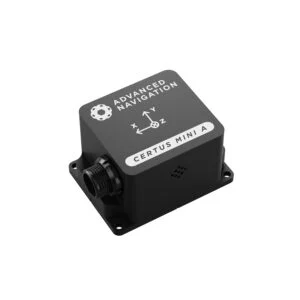
This high-performance device is perfect for various drone and robotics applications, seamlessly integrating with industry-standard protocols such as NMEA 0183 and CANOpen, along with ROS 1, ROS 2, and Ardupilot.
Key Features:
- 0.1° Roll & Pitch
- 0.8° Magnetic Heading
- Rugged & OEM options available
Learn more: Certus Mini A MEMS AHRS Sensor
motus Miniature MEMS IMU Sensor
Ultra-Precise Miniature Inertial Sensor for UAVs
Motus is a compact, ultra-precise MEMS IMU that integrates high-accuracy accelerometers and gyroscopes with magnetometers, delivering inertial performance that surpasses some FOG IMUs.
With a volume slightly over 1 cubic inch and a weight of just 26 grams,Motus is ideal for applications where size,weight,and power are critical,such as geopointing and LiDAR missions with VTOL UAVs.
Key Features:
- Hot Start Time: 2 seconds
- IMU, AHRS, and INS configurations
- Available in OEM or Rugged versions
Discover more: Motus Miniature MEMS IMU
More information: High-performance and compact IMU & AHRS >
Precision MEMS GNSS/INS Solutions
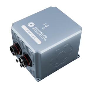
Certus and Certus Evo GPS-aided INS & AHRS
Durable Low-SWaP Positioning Solutions for UAVs and Robotics
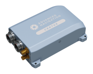
Certus and Certus Evo are robust, low-SWaP, ITAR-free GPS-aided INS and AHRS modules that integrate temperature-calibrated accelerometers, gyroscopes, magnetometers, and a pressure sensor with a dual antenna RTK GNSS receiver, all enhanced by a state-of-the-art AI-based sensor fusion algorithm.
Thes modules feature dual antenna moving baseline RTK,providing highly accurate heading data for both stationary and mobile platforms,even in magnetically challenging environments.
Certus and certus Evo are perfect for UAV and USV surveying,targeting antenna and weapon platforms,and stabilizing robotic systems.
Key Features:
- Dual Antenna Heading
- Free Multi-Constellation RTK
- Multiple Interfaces: Ethernet, CAN, RS232, RS422, and GPIO
- Internal Data logging
- OEM or Rugged options
Learn more: Certus and Certus Evo GPS-Aided INS
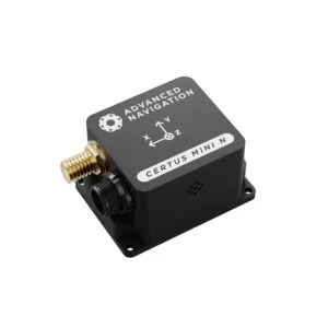
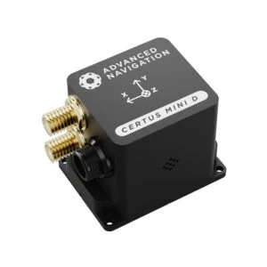
Certus Mini N & Mini D MEMS GNSS/INS
SWaP-Optimized Single and dual-Antenna GNSS/INS
The Certus Mini N and mini D provide precise and reliable attitude and heading data in a rugged design, featuring either a single or dual-antenna GNSS receiver with L1/L5 multi-constellation RTK positioning for maximum accuracy. These low-SWaP sensors utilize Advanced Navigation’s cutting-edge AI-powered fusion algorithm, achieving accuracy levels up to ten times that of traditional Kalman filters.
These high-performance units are suitable for a variety of drone and robotics applications and are fully compatible with industry-standard protocols, including NMEA 0183 and CANOpen, as well as ROS 1, ROS 2, and Ardupilot.
Key Features:
- 0.1° Roll & pitch
- 0.2° (Mini N) / 0.1° (Mini D) GNSS Heading
- 10 mm RTK Positioning
- Rugged & OEM options
Learn more: Certus Mini N & Mini D MEMS GNSS/INS
More information: High-accuracy MEMS GNSS/INS solutions >
High-Performance FOG INS Solutions
spatial FOG Dual GPS-Aided INS/AHRS
Durable FOG INS with Dual antenna Heading
The Spatial FOG Dual is a dual-antenna moving baseline RTK variant of the Spatial FOG GPS-aided INS/AHRS. It delivers highly accurate heading output while stationary and in motion. The triple-frequency Trimble RTK GNSS receiver achieves positioning accuracy of up to 8mm and supports all current and future satellite navigation systems,along with the Omnistar service for enhanced positioning accuracy.
Key Features:
- Dual Antenna Heading
- L1/L2 RTK/PPK
- Hot Start Time: 2 seconds
- Compact Size,Weight,and Power Consumption
Learn more: Spatial FOG Dual GPS-Aided INS/AHRS
Boreas D90 Digital FOG INS
strategic-Grade INS with Low SWaP-C
the Boreas D90 is an ultra-precise, strategic-grade INS that boasts a 40% reduction in size, weight, power consumption, and cost compared to competing systems. It is the first product utilizing Advanced Navigation’s new DFOG (Digital Fiber Optic Gyroscope) technology,developed over 25 years in collaboration with two research institutions.
The Boreas D90 is designed for applications requiring constant, ultra-precise orientation and navigation, including marine, surveying, subsea, aerospace, robotics, and space.
Key Features:
- Dual Antenna Heading
- GPS L1,L2,GLONASS L1,L2,GALILEO E1,E5b,BeiDou B1,B2,RTK/PPK
- Hot Start Time: 2 seconds
- Compact Size,Weight,and Power consumption
Learn more: Boreas D90 Digital FOG INS
More information: High-performance FOG INS solutions>
Acoustic Underwater Navigation
subsonus underwater Acoustic positioning System
High-Precision, Miniature USBL for AUVs and ROVs
Subsonus is a state-of-the-art USBL underwater acoustic positioning system that integrates an industry-leading eight-channel factory-calibrated hydrophone array with an internal tightly coupled INS. It operates at depths of up to 1000 meters, merging acoustic positioning and Doppler velocity with factory-calibrated inertial sensors and a depth sensor, yielding highly accurate position, velocity, and heading outputs.
Subsonus is ideal for station-keeping, control, and subsea surveying applications for both AUVs (autonomous underwater vehicles) and ROVs (remotely operated vehicles).
Key Features:
- Sound Velocity Sensor
- Minimal Size, Weight, and Power Consumption
- Multipath Rejection
- Acoustic Modem
- Integrated INS
- Speed of Sound Sensor
Learn more: Subsonus Underwater Acoustic Positioning System
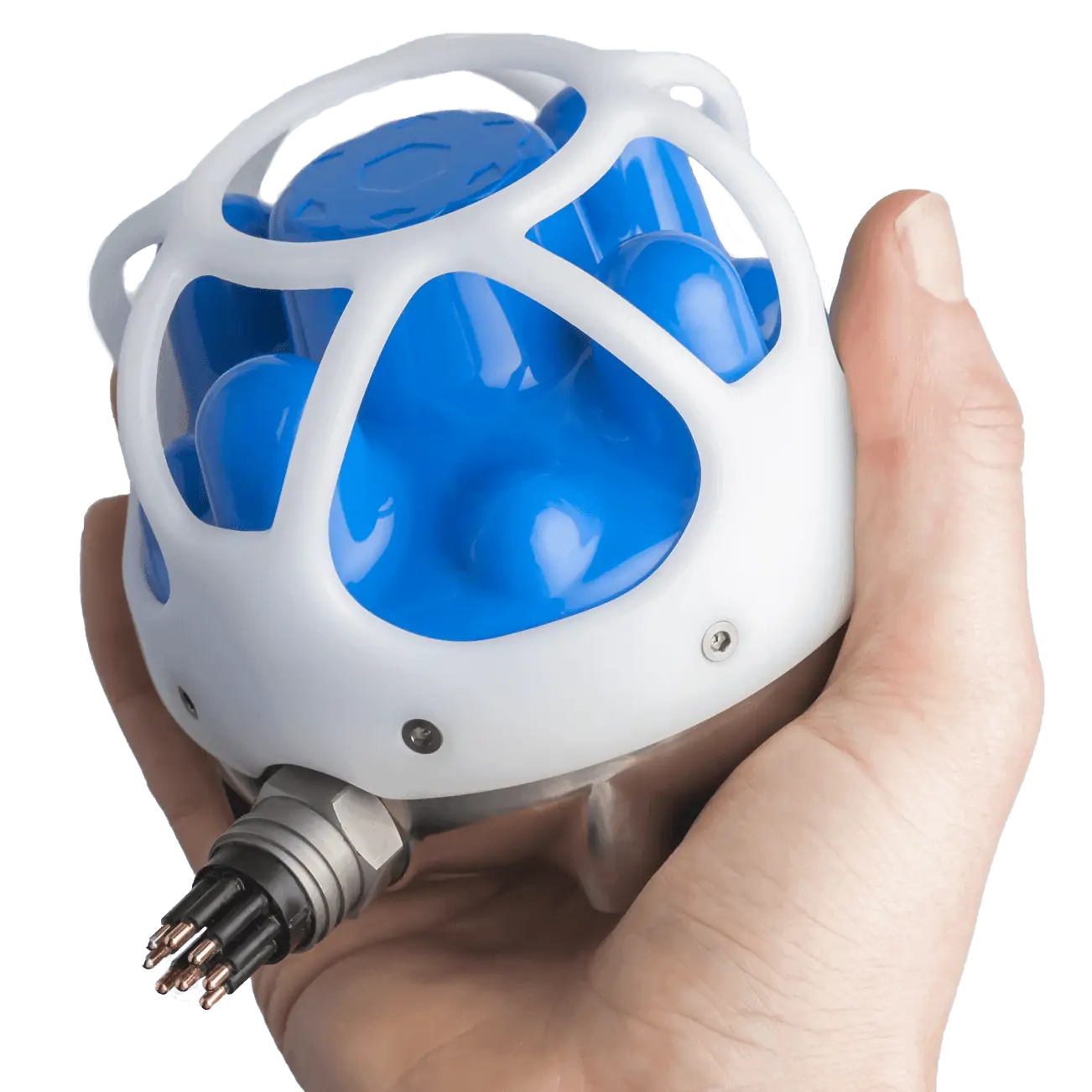
Subsonus Tag Acoustic Positioning Transponder
Cost-Effective Sensor for Subsea remote Sensing and Tracking
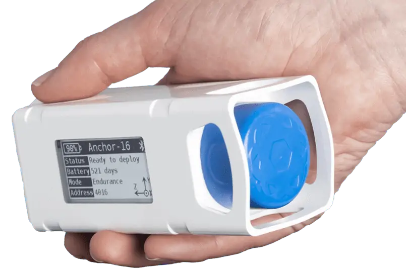
Subsonus Tag is an economical acoustic positioning transponder designed for use with our Subsonus USBL. This hermetically sealed unit features an integrated battery, wireless charging, and a low-power pressure-tolerant e-paper display. Up to 65,000 tags can be tracked by a single surface Subsonus unit, with each tag operating at a range of up to 1000 meters and at depths of up to 2000 meters for up to 18 months on a single charge.
subsonus tag is perfect for remote sensing of position, orientation, heading, and temperature, and also tracking underwater unmanned vehicles like auvs and ROVs.
Key Features:
- 18 Months Battery Life
- Minimal Size, Weight, and Power Consumption
- No maintenance Required
- Cost-Effective
- integrated Display
Learn more: Subsonus Tag Acoustic Positioning Transponder
More information: Acoustic Underwater Navigation solutions >
Post-Processing Software

Kinematica Post-Processing Software
Web-Based GNSS/INS Post-Processing Software
Kinematica is a web-based post-processing software for raw GNSS and inertial data from any of our GNSS/INS products.
Kinematic GNSS post-processing can enhance position accuracy by up to 200 times compared to standard real-time GNSS. The Kinematica software automatically retrieves data from the nearest RINEX base station, providing position accuracy of 8mm.
Kinematica employs both forward and backward time analysis to address satellite outages and correct errors that typically affect real-time solutions. It supports both loosely and tightly coupled GNSS/INS processing, automatically switching to ensure optimal accuracy based on current conditions.
This software is ideal for post-processing data collected from surveying, LiDAR, and aerial photography applications.
Learn more: kinematica Post Processing Software
Micro-AUV
Hydrus Autonomous Underwater Vehicle
Micro-AUV for Underwater Surveying & Inspection

Hydrus is a compact AUV designed to capture high-resolution images and videos with precise geo-referenced data, simplifying underwater surveying and inspection tasks.
The all-in-one autonomous vehicle features a 4K 60 FPS camera paired with powerful lighting, as well as tightly integrated USBL, DVL, INS, and acoustic and optical modems.
The innovative design incorporates hubless thrusters to prevent impellers from becoming entangled with ropes or seaweed, ensuring high reliability and low maintenance.
Hydrus also includes an AI-driven image processing system that dynamically adjusts camera settings and lighting, compensating for turbidity even in challenging environments.
Learn more: Hydrus Autonomous Underwater Vehicle


