SBG SYSTEMS is a leading supplier of MEMS-based ITAR Free inertial motion sensing solutions. From miniature inertial navigation systems to high accuracy INS GPS, SBG SYSTEMS sensors offer a unique balance of price – size – performance for unmanned systems navigation.
SBG Systems offers a complete line of inertial sensors based on the state-of-the-art MEMS technology, such as Attitude and Heading Reference System (AHRS), Inertial Measurement Unit (IMU), and embedded GPS Inertial Navigation System (INS/GPS). Combined with cutting-edge calibration techniques and advanced embedded algorithms, our inertial sensors are ideal solutions for unmanned vehicle control, antenna tracking, camera stabilization, and surveying applications.
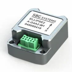
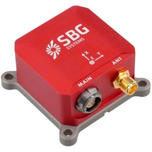
Ellipse Micro Series – IMU & AHRS
Smallest Size High-Performance IMU and AHRS for Unmanned Applications
 High accuracy (0.1° Roll/Pitch) industrial grade micro inertial sensors with the smallest form factor:
- Extremely light weight at 10 grams
- Industrial grade high-end gyroscopes and accelerometers
- Extended calibration, from -40 to +85°C for constant behaviour in a wide range of environments
- Fusion with GNSS receiver for robust and accurate position, heave and heading output
- Specific motion algorithms fine-tuned for land systems such as UGVs and autonomous driving
- Cost-effective – designed for volume projects.
 |
|
|
| Ellipse Micro IMU | Ellipse Micro AHRS | |
| Calibrated IMU data | ✔️ | ✔️ |
| Roll, Pitch, Heading | X | ✔️ |
| Heave | X | ✔️ |
| Navigation | X | X |
More Information: Ellipse Micro Series
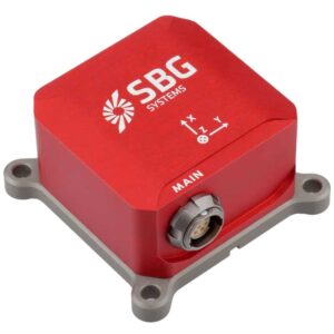
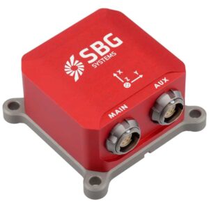
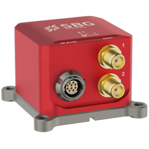
Ellipse Series – Industrial-Grade Inertial Sensors
Robust, high-performance inertial sensors for small unmanned systems
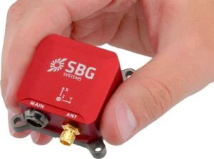 3rd Generation, ITAR-free miniature inertial sensors with an extremely rugged design, cutting-edge sensors, and advanced algorithms:
- 0.05° RMS accuracy
- Very Low Noise Gyroscopes
- Embedded 64Bit microprocessor
- Integrated GPS + GLONASS/BEIDOU receiver
- Accepts DGPS corrections and Odometer inputs
- High-level algorithms for vibrations and magnetic disturbances handling.
 |
 |
 |
 |
|
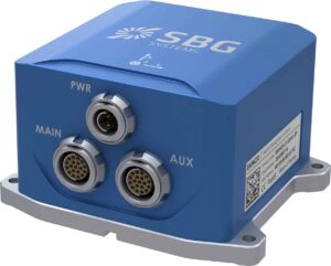
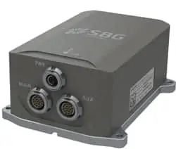
| Ellipse-A Orientation + Heave Motion Sensor |
Ellipse-E INS with your own external GNSS receiver |
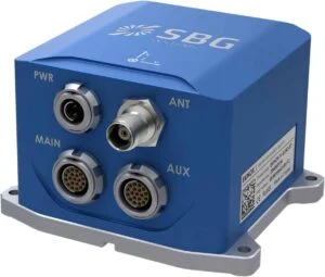
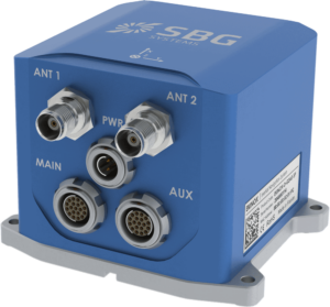
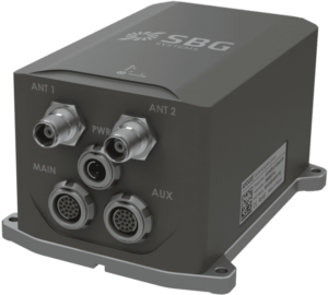
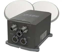
Ellipse-N Single Antenna RTK INS with integrated GNSS receiver |
Ellipse-D Dual Antenna RTK INS with integrated GNSS receiver |
|
| Roll and Pitch | 0.1°over 360° | 0.05° RTK | 0.05° RTK | 0.05° RTK |
| Heading | 0.8° Heading (Internal Magnetometers) | Magnetic or GNSS Heading | 0.2° Heading (RTK high dynamics) | 0.2° Heading (Dual Antenna RTK GNSS) |
| Heave | 5 cm Real-time Heave | 5 cm Real-time Heave | 5 cm Real-time Heave | 5 cm Real-time Heave |
| Navigation | X | Navigation with external GNSS receiver | L1/L2 GNSS receiver 1 cm RTK GNSS Accuracy |
L1/L2 GNSS receiver 1 cm RTK GNSS Accuracy |
| Post-Processing | X | ✔️ | ✔️ | ✔️ |
More Information: Ellipse Miniature Inertial Navigation Systems
Quanta UAV Series
High-accuracy INS/GNSS for UAV-based Surveying Solutions
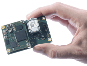
The Quanta series is a high-accuracy GNSS-aided Inertial Navigation System designed for UAV and land-based surveying solutions.
- Lightweight and low-power
- Extended Kalman Filter fuses inertial and GNSS data for the highest performance in the most challenging conditions
- Direct geotagging of point cloud in real time for more accuracy in post-processing
- Direct georeferencing eliminates need for ground control points and reduces need for overlapping
- Also ideal as a high-end navigation solution for UAV autopilots.
More Information: Quanta UAV Series INS/GNSS
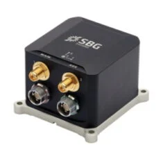
Tactical-Grade IMU
Pulse-40
Miniature tactical-grade 6 DoF IMU for UAVs & unmanned systems
 The Pulse-40 is a tactical-grade inertial measurement unit designed to provide robust high-precision stabilization and navigation under even the harshest of conditions. Incorporating state-of-the-art MEMS three-axis accelerometers and gyroscopes in a unique redundant design, it features extremely low VRE (Vibration Rectification Error), and is ideal for high frequency dynamics and high-vibration environments.
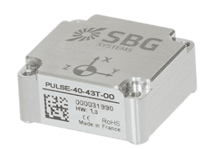 Weighing just 12 grams and drawing 0.3W, the Pulse-40’s extremely low SWaP footprint makes it ideal for a variety of drones and robotic platforms. The unit features redundant sensor integration and embedded Continuous Built-In-Test, providing the utmost in data reliability for critical applications.
Main Features:
- Best SWaP-C: 12 grams, 0.3W Power consumption
- Ultra-Low Noise Gyro (0.08°/√h) and excellent Gyro Bias Instability (0.8°/h)
- High-precision Accelerometers (6µg)
- Low Vibration Rectification Error: Shocks and vibrations MIL-STD 810 qualified
- High Bandwidth (480Hz) and High data rate (2KHz)
- Highly Tested and Calibrated from -40°C to 85°C
- No export restrictions
More Information: Pulse-40 Tactical-Grade IMU
Ekinox Series
Mid Accuracy AHRS and INS/GNSS for High Performance Unmanned Systems
 Mid accuracy (0.02° attitude) in a cost-effective and compact package:
- Fusion with Odometer, GNSS and DVL for the best accuracy
- Internal L1/L2 Survey-grade GNSS receiver
- Low latency, high output rate for demanding applications
- Post-processing feature for Surveying applications
- Motion profiles tuned for UAVs, UGVs, and UUVs specific dynamics
 |
|
 |
 |
|
| Model | Ekinox-A | Ekinox-E | Ekinox-D | Ekinox-Micro |
| Roll, Pitch, Heading | ✔️ | ✔️ | ✔️ | ✔️ |
| Heave | ✔️ | ✔️ | ✔️ | ✔️ |
| Navigation | X | ✔️ Connection to external GPS | ✔️ Integrated dual-antenna GNSS receiver | ✔️ Integrated dual-antenna GNSS receiver |
More Information: Ekinox Inertial Navigation System
High Accuracy INS
Apogee Series
High-accuracy AHRS and INS/GNSS for Survey Unmanned Systems
 The Highest accuracy (0.005° orientation) in a cost-effective, small INS package:
- Fusion with Odometer, GNSS and DVL for the best accuracy
- Internal L1/L2/L5 Survey-grade GNSS receiver
- Low latency, high output rate for demanding applications
- Post-processing software for Surveying applications
- Motion profiles tuned for UAVs, UGVs, and UUVs specific dynamics

More Information: Apogee High Performance INS
Post-Processing Software
Qinertia
INS/GNSS post-processing software
Qinertia is our next-generation GNSS/INS post-processing software, with access to offline, always up-to-date RTK corrections from more than 7,000 base stations located in 164 countries.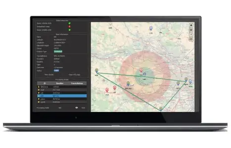
Designed to support all GNSS receivers and third-party IMUs, it features an advanced proprietary tight coupling algorithm designed to deliver the highest accuracy and maximize RTK availability.
The software also features Virtual Base Station (VBS) functionality, creating a virtual network around your project and providing centimetre-level accuracy even for corridor mapping, locations far from base stations, and in poorly covered RTK areas.
Qinertia is available in four different tiers:
- Qinertia Pro – full-featured GNSS/INS post-processing solution supporting all SBG sensors and third-party IMUs
- Qinertia Lite – economical solution for UAV and land-based projects, supporting all SBG sensors
- Qinertia UAV – designed for UAV-based surveying and photogrammetry applications
- Qinertia GNSS – static and kinematic GNSS data processing only, supporting any receiver
More Information: Qinertia INS/GNSS post-processing software

SBG Systems’ Support Center
We are very proud to present our new platform which aims to make your integration phase even easier.
The Support Center is the place where you will find all resources related to SBG inertial sensors, such as the getting started process, user manuals, firmware, but also FAQs, and tutorials.
Consult the Knowledge area and learn about inertial and GNSS technologies!


