
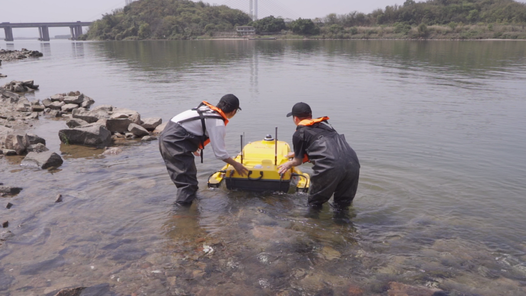
SatLab Geosolutions engaged in a groundbreaking initiative to chart the underwater landscape of a vital waterway adjacent to a cargo terminal, utilizing its HydroBoat 1500 unmanned surface vehicle (USV) integrated with the HydroBeam M4 multibeam echosounder.
Underwater surveys play a crucial role in various sectors, including ensuring safe navigation for vessels, mapping submerged resources, monitoring coastal erosion, evaluating aquatic ecosystems, and inspecting underwater infrastructure such as pipelines and cables.
While these surveys are essential, they ofen present challenges, including high expenses, prolonged timelines, and constraints related to water depth and visibility.
Recent innovations are revolutionizing this domain. The combination of unmanned surface vehicles (USVs) and multibeam echosounders (MBES) is establishing new benchmarks in underwater surveying by providing intricate 3D representations of the seabed.
This synergy signifies a major leap forward, transforming the underwater surveying industry and fostering a more lasting approach to oceanic conservation. A prime illustration of this technology’s request is in the surveying of underwater pipelines.
Over time, sediment accumulation on the seabed can diminish navigable water depth.Bathymetric surveys pinpoint areas that necessitate dredging, ensuring that waterways maintain sufficient depth for large cargo ships to pass safely.
This proactive approach helps avert grounding incidents that could jeopardize vessels and harm marine ecosystems. Multibeam technology excels in this scenario, delivering highly detailed and precise underwater topographic information.
Challenges of Conventional Surveying
Traditional surveying techniques typically depend on large vessels outfitted with intricate systems, which often struggle with maneuverability and navigation. Although effective in deep, open waters, these methods are less adept in shallow or congested areas, such as the waterway involved in this project.
Innovative Solutions by SatLab
Considering the shallow water conditions and the active shipping traffic in the vicinity, a portable multibeam echosounder system mounted on a USV emerged as the ideal solution.
The satlab HydroBoat 1500 USV, a cutting-edge platform specifically designed for multibeam bathymetric surveys, was utilized for this initiative.Its unique quad-thruster configuration, akin to a trimaran hull, ensures remarkable stability. Furthermore, the system guarantees continuous operation even if two thrusters fail, with the remaining thrusters maintaining propulsion.
The integration of the HydroBoat 1500 USV with the HydroBeam M4 multibeam echosounder provided several meaningful advantages:
- Rapid data acquisition: USVs can autonomously cover large areas quickly, while multibeam echosounders offer wider coverage compared to traditional single-beam systems.
- Increased safety: USVs can operate in risky or hard-to-reach locations, reducing risks to personnel.
- Enhanced data integrity: usvs consistently gather data, bolstering the reliability of the findings.
Execution Strategy
Field Data Collection
- Survey planning: Survey lines were organized in parallel to ensure comprehensive area coverage, with spacing adjusted according to water depth. Perpendicular check lines were employed to verify measurement accuracy.
- Tide monitoring: Real-Time Kinematic (RTK) tide verification was utilized to ensure accurate water depth measurements. Continuous GNSS system monitoring detected any anomalies, preserving measurement precision.
- Installation and calibration: The transducer was positioned in the HydroBoat 1500’s moon pool and calibrated for roll, pitch, and yaw to correct any positional discrepancies.
data Processing
The gathered data was processed using SLHydro software, involving steps such as terrain mapping, water depth data validation, chart editing, and graphic production, culminating in a final chart.
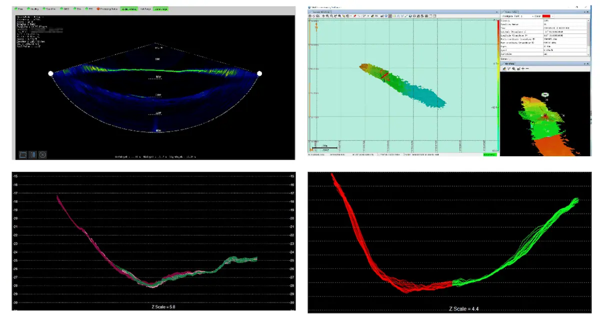
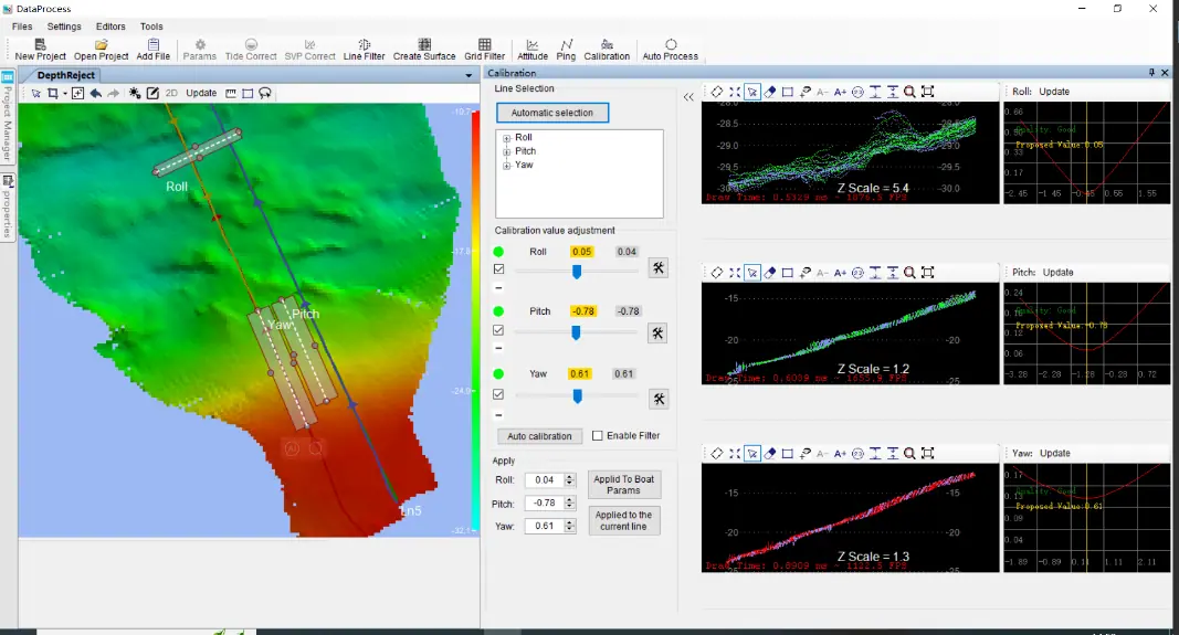
Data Processing in SLHydro software
Outcomes
Detailed Underwater Terrain Mapping
The HydroBoat 1500 USV and HydroBeam M4 multibeam echosounder facilitated the creation of intricate underwater maps of the waterway, providing accurate insights into the submerged landscape.
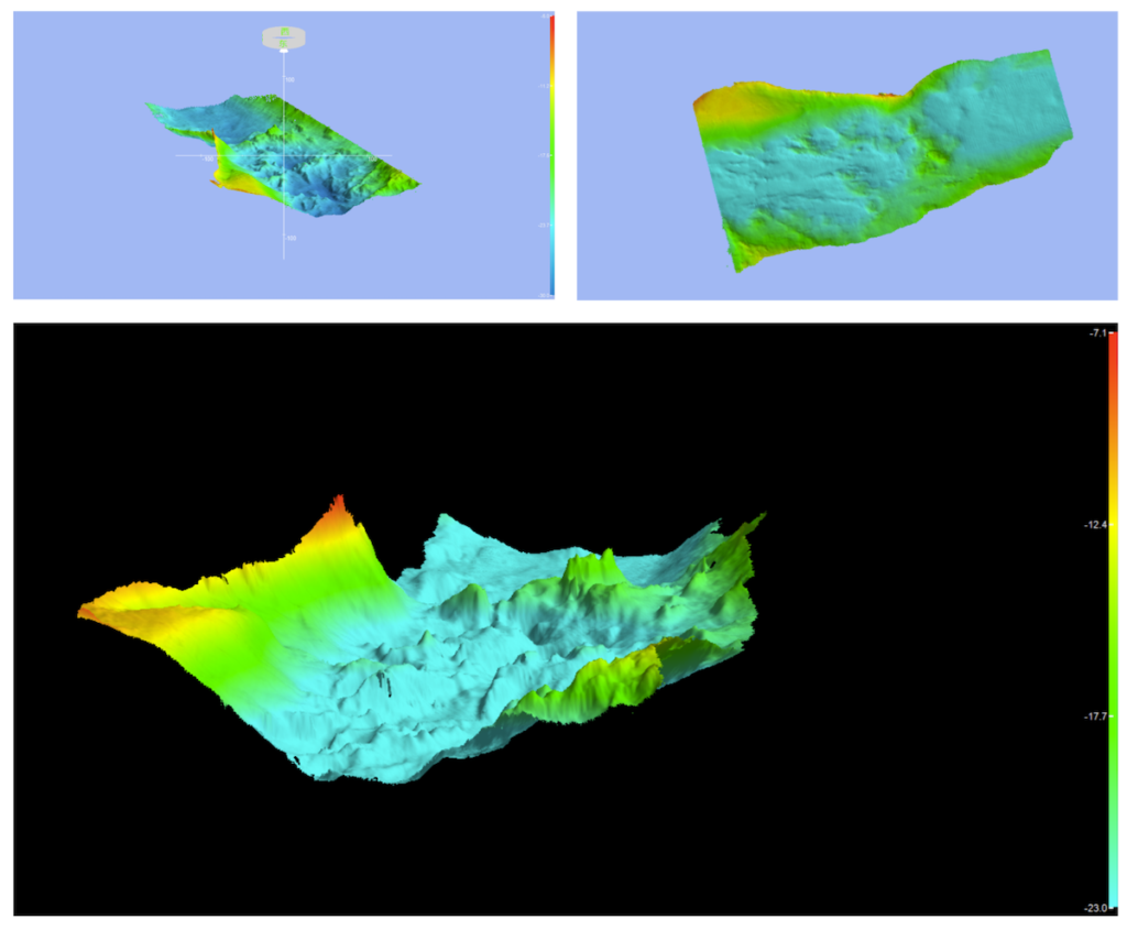
High-resolution underwater terrain maps
Adherence to IHO Standards
Calibration data analysis confirmed that the HydroBeam M4 met the stringent accuracy standards set by the International Hydrographic Organization (IHO) Class A, ensuring the dependability of the collected data.
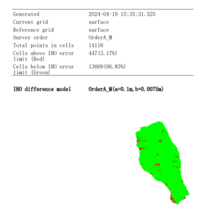
Compliant with IHO standards
Advantages
The hydroboat 1500 USV and HydroBeam M4 system successfully completed the survey of this crucial waterway. The HydroBoat 1500’s innovative moon pool design,waterproof mounting bracket,and compatibility with various third-party multibeam systems enhance its adaptability.
Moreover,the support for additional onboard sensors,including Acoustic Doppler Current Profilers (ADCPs) and side-scan sonars,expands its utility for a variety of tasks and measurement requirements.
Final Thoughts
This initiative underscores the potential of USV and MBES technologies in providing accurate data for vital operations such as maintaining waterways, ensuring safe navigation, and managing shipping routes.
The integration of these advanced technologies signifies a pivotal advancement in underwater surveying,improving efficiency,safety,and data quality across multiple sectors. This progress contributes to a deeper understanding and sustainable management of underwater ecosystems.
Read the original article >>


