The Apus-MX UAV LiDAR system from SatLab Geosolutions, paired with Sat-LiDAR processing software, was utilized for a debris flow disaster assessment in Chengdu, Sichuan Province, China.
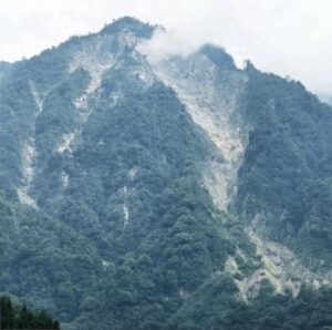
Survey Area
This system is engineered for precise and efficient data collection in challenging terrains, gathering essential information for risk assessment and early warning systems following heavy seasonal rains.
During the flood season, numerous debris flow incidents impacted the mountainous regions due to heavy rainfall, extended precipitation, and snowmelt.
In response to local government directives, a technical survey was initiated to evaluate geomorphological features, vegetation density, surface changes, and hydrological conditions across two specified areas.
Area 1 encompassed 0.5 km² with elevations ranging from 1,400 to 2,300 meters,while Area 2 covered 0.35 km² with elevations between 1,150 and 1,450 meters. Both locations were characterized by dense forests and intricate vegetation layers.
Strategic Deployment & Technical Implementation
Conventional surveying techniques were deemed hazardous and unreliable due to the steep, wooded slopes, unpredictable weather patterns, and limited accessibility. Additionally, the elevation difference from available launch sites to the highest terrain points was nearly 1,000 meters.
SatLab Apus-MX mounted on the DJI M350
To address these challenges, a DJI Matrice 350 RTK drone equipped with the Apus-MX LiDAR was chosen for its ability to perform high-altitude flights and gather detailed data in remote and obstructed areas. Three ground-proximity flight missions were conducted to ensure comprehensive area coverage.
The system utilized RTK positioning and a CORS network for accurate georeferencing.The Sat-LiDAR software processed the acquired point cloud data, facilitating the automatic generation of high-resolution outputs such as Digital Elevation Models (DEMs), Digital Surface Models (DSMs), contour lines, and terrain classifications.
it also enabled multi-phase volume calculations using a Triangulated Irregular Network (TIN) grid and included advanced features for data accuracy verification,strip adjustment,noise reduction,classification,and point cloud tiling.
Data Results & Insights
the final output achieved an average point cloud density of 127 points per square meter, with ground points remaining dense and continuous even beneath thick vegetation. the accuracy exceeded 2 cm, fully satisfying the project’s technical specifications. The Apus-MX LiDAR system demonstrated a measurement range of up to 1,200 meters at 60% reflectivity, with a laser pulse rate of 550,000 shots per second.
Fully compatible with the DJI platform, the Apus-MX LiDAR system provided safe, efficient, and non-contact data acquisition in challenging environmental conditions.
With the Sat-LiDAR software offering comprehensive data processing and analysis, this solution enabled precise evaluations of topography, deformation, vegetation, and hydrology in areas susceptible to debris flows, thereby supporting effective disaster monitoring and mitigation strategies.
Read the original article >>


