
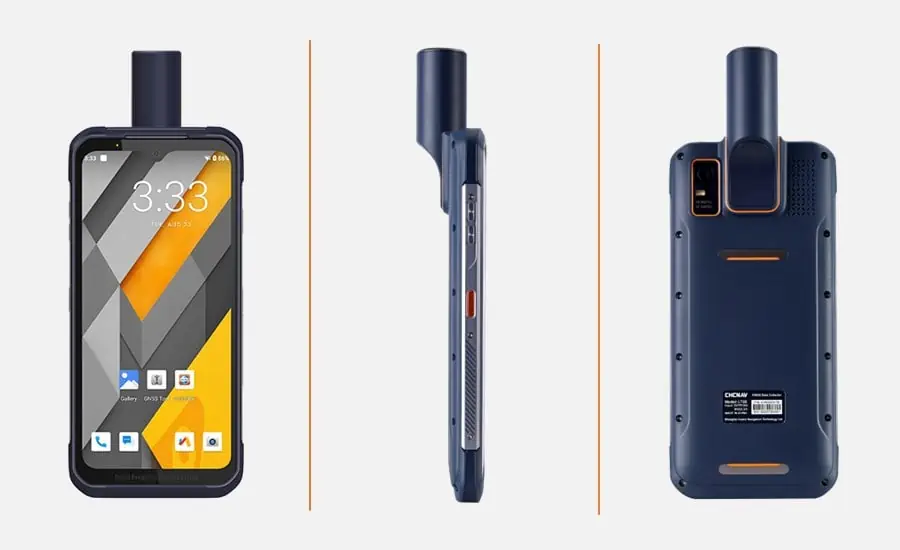
Introducing the LT60H: A Cutting-Edge Rugged Smartphone for Precision GIS Applications
CHC Navigation has unveiled the LT60H, a state-of-the-art rugged smartphone specifically designed for high-precision Geographic Information system (GIS) data collection and outdoor tasks. With its survey-grade GNSS positioning capabilities, robust IP67-rated build, and a display optimized for luminous sunlight, the LT60H guarantees reliable centimeter-level accuracy, even in the most challenging environments.
Advanced GNSS Technology for Unmatched Accuracy
Equipped with a high-performance GNSS positioning module, the LT60H supports multiple satellite constellations, including GPS, GLONASS, Galileo, and BeiDou. This device boasts 1408 GNSS channels and a quadrifilar helix antenna, providing full support for GNSS RTK network corrections.As a result, users can expect centimeter- too decimeter-level accuracy, even under tough conditions.
Seamless Connectivity and User-Friendly Features
Powered by Android 12, the LT60H offers a suite of connectivity options, including 4G, WiFi, Bluetooth 5.1, and NFC. This ensures that field teams can easily integrate third-party data collection applications, allowing for precise capture of locations, images, videos, measurements, and other geospatial information. The device features a high-definition screen with over 400 DPI and a brightness of 550 cd/㎡,ensuring clarity and detail in direct sunlight. Its 5-point capacitive touch screen is designed for versatility,enabling data entry with a stylus,gloves,or even wet hands,making it suitable for various operational scenarios.
Robust Design for Demanding Environments
the LT60H is engineered as an all-in-one solution to enhance productivity in site layout, surveying, GIS data collection, utility asset management, and other applications that demand high-precision location data. Its industrial-grade IP67 rating guarantees protection against dust,shocks,vibrations,drops,water immersion,and extreme temperatures.the device can endure drops from heights of up to 1.5 meters onto concrete, ensuring data integrity even in accidental falls. The 6.3-inch Gorilla Glass display combines resilience with excellent visibility in bright conditions. Additionally, the LT60H is powered by a 6000 mAh battery, providing up to 8 hours of continuous operation on a single charge.
Expert Insights on the LT60H
Sans Ma, Product Manager at CHC Navigation, stated, “The LT60H represents a significant advancement in handheld data collection for surveyors, construction teams, asset managers, and any professionals who depend on geospatial precision. Its rugged construction, integrated high-precision GNSS technology, and powerful hardware make the LT60H an essential tool for enhancing the efficiency of mobile workforces.”


