
Achieving centimeter-level accuracy with GNSS technology requires a careful choice between two primary methods: Real-time Kinematic (RTK) and Post-Processed Kinematic (PPK). In this article, ArduSimple examines the key differences to help users determine the most suitable approach for their specific project needs.
For centimeter-level precision, GNSS systems utilize two components: a stationary RTK base station and a mobile rover. The base station transmits correction signals to the rover, ensuring precise data collection.
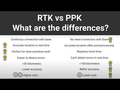
RTK provides instantaneous corrections, making it ideal for applications like precision agriculture and on-site surveying. Conversely, PPK processes data after collection, which is favorable for remote or intricate projects where immediate results are not critical.
Check out the video below for an in-depth look at the technical aspects of RTK and PPK, and discover which solution best fits your GNSS requirements.
Real-World Uses
- RTK: Ideal for real-time navigation and field tasks that demand immediate feedback, such as precision planting and equipment guidance.
- PPK: Best suited for data gathering in isolated areas, archaeological surveys, or situations where real-time connectivity is unavailable.
Flexibility with Dual-Function Systems
Integrating both RTK and PPK functionalities into a single system provides versatility for a wide range of applications, from drone mapping to land surveying. ArduSimple’s kits are designed to accommodate both modes,ensuring they meet various project demands.
For newcomers to GNSS technology, RTK has become increasingly user-pleasant, streamlining the process for achieving immediate accuracy.


