
Inspired Flight emphasizes that in modern precision farming,acquiring timely and precise data is crucial for maintaining crop vitality and optimizing resource utilization.
The integration of multispectral imaging with sophisticated analytics provides farmers with critical insights into crop conditions that are often difficult to identify through conventional techniques.
This report outlines the results from a drone mission conducted over a baby lettuce field, utilizing the Sentera 6X multispectral sensor mounted on an IF800 Tomcat to assess chlorophyll levels and overall plant health.
The flight covered an area of 8.47 acres and lasted just over 7 minutes, yielding actionable data to enhance crop management practices.
mission Overview
• Location: Babe Farms,Santa Maria,CA
• Crop: Baby lettuce
• Area covered: 8.47 acres
• Flight duration: 7 minutes and 12 seconds
• Equipment used: Sentera 6X multispectral sensor on the IF800 Tomcat
The objective of this mission was to collect data during the initial growth phases of the lettuce crop. By utilizing multispectral imaging focused on the chlorophyll Index Green (CIG),a thorough evaluation of the crop’s health was conducted,providing insights into chlorophyll levels,nitrogen content,and early signs of stress.
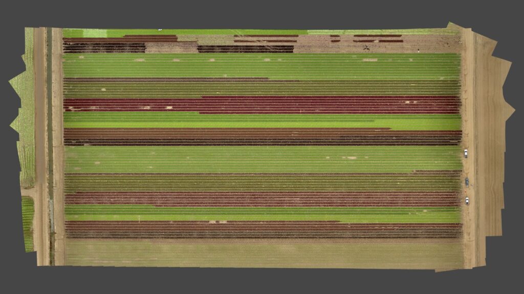
Orthomosaic of the surveyed baby lettuce field
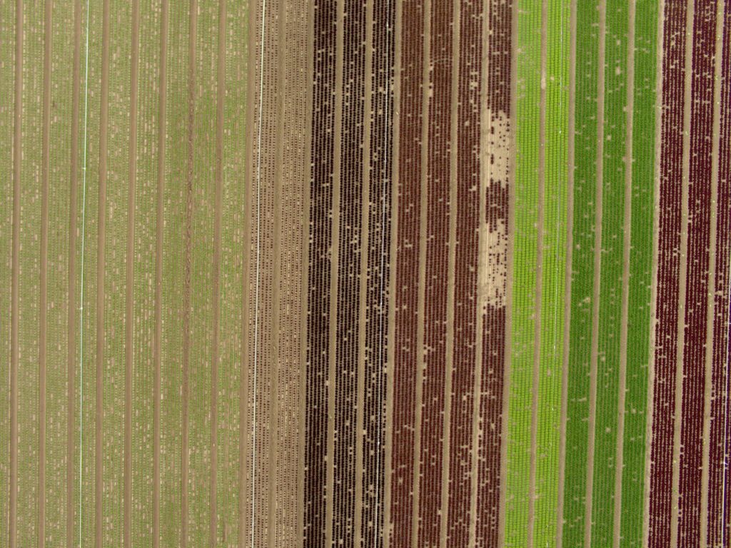
Closeup view from the 20 MP RGB camera on the 6X Multispectral, showcasing clear details across crop rows. This high-resolution imagery allows farmers to identify subtle variations and pinpoint areas with gaps or irregular growth that might be overlooked during traditional scouting due to the field’s size.
The RGB imagery captured by the 6X multispectral sensor provides an aerial viewpoint that simplifies the identification of issues such as plant gaps, uneven growth, and other potential problems across extensive fields. This capability enables more precise field management and timely responses to challenges that might potentially be difficult to detect from the ground.
Decoding the Chlorophyll Index Green (CIG)
The Chlorophyll Index Green (CIG) serves as a vital metric in multispectral imaging, comparing near-infrared and green light bands to provide insights into chlorophyll concentrations in plants. Chlorophyll is essential for photosynthesis, and it’s levels indicate a plant’s ability to produce energy and grow. The CIG is especially useful for early-stage crops, where green reflectance acts as a sensitive indicator of chlorophyll content.
Advantages of CIG Data:
- Chlorophyll sensitivity: During early growth phases, CIG is highly responsive to changes in chlorophyll, offering real-time insights into plant photosynthesis and health.
- Nitrogen assessment: Since chlorophyll levels correlate directly with nitrogen content,CIG data helps identify nitrogen deficiencies,allowing for precise adjustments in fertilization strategies to prevent under- or over-fertilization.
- Water stress and disease identification: Chlorophyll content is influenced by water availability and environmental stress. low CIG values may indicate water stress, pest problems, or disease, prompting early intervention.
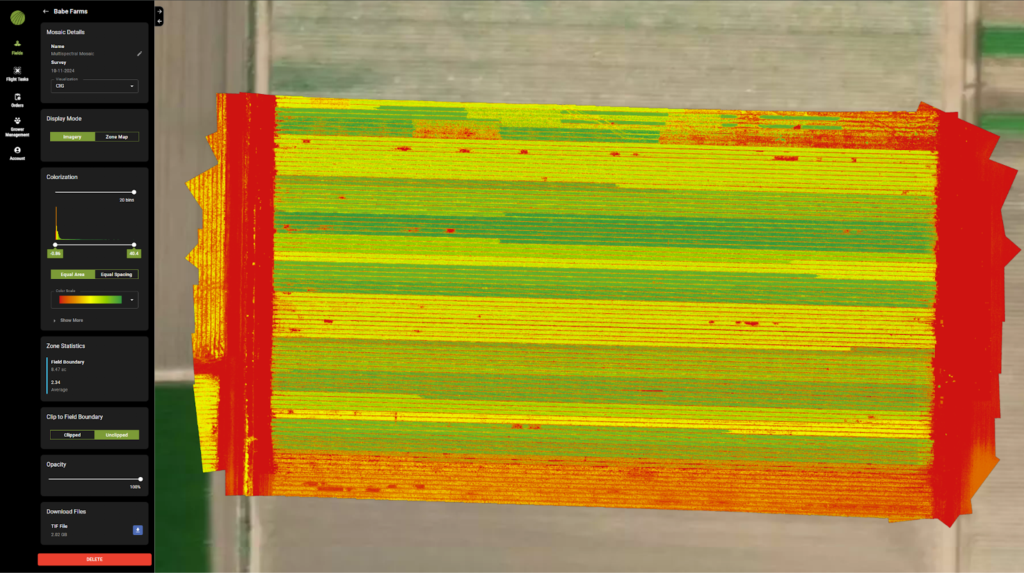
CIG heat map showing plant health
NDVI: Assessing Crop Vitality
The normalized Difference vegetation Index (NDVI) is a powerful tool for assessing plant health across agricultural landscapes. NDVI evaluates the difference between reflected near-infrared light and absorbed red light. When plants reflect more near-infrared light than red light, it indicates healthier vegetation, resulting in elevated NDVI values.
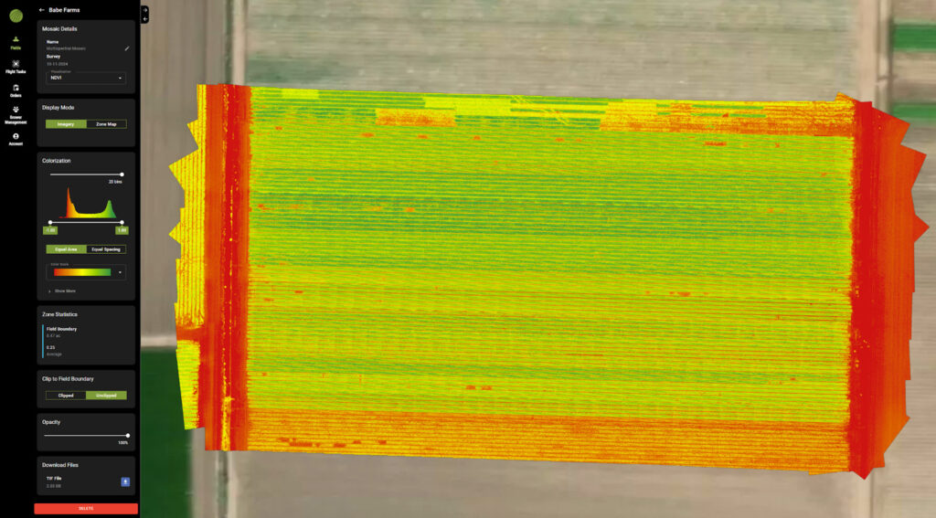
NDVI Crop health
During the mission at Babe Farms, the NDVI data indicated that nearly all plants in the field were in good health. Beyond assessing plant vitality, NDVI can also estimate the area of healthy biomass.This is achieved by refining the NDVI histogram’s binning to 1 and adjusting the displayed NDVI value range from 0 to 1, effectively isolating the vegetation. The area can then be summed to determine the biomass-covered region.
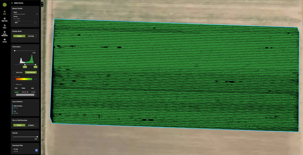
Using NDVI to quantify healthy vegetation
In this analysis, it was found that 5.72 acres were covered with vegetation exhibiting an NDVI value of 0 or higher. These results indicated strong overall plant health in the area,along with the presence of harvestable biomass,underscoring the effectiveness of the monitoring efforts.
The NDVI scale quantifies vegetation health based on reflectance data captured by the Sentera 6X multispectral sensor. Higher NDVI values correlate with denser, healthier vegetation, making it an essential metric in precision agriculture.This information aids farmers in making informed decisions regarding resource management, pest control, and fertilization, ultimately optimizing yields and promoting sustainability.
Data Analysis & Results
Summary of Flight Data
the high-resolution multispectral imagery obtained during the flight was processed to create a CIG index map, which was then overlaid on the RGB mosaic of the field. This analysis provided a comprehensive understanding of crop health across the entire 8.47 acres.
Chlorophyll Distribution:
• High CIG values: Indicated areas of healthy lettuce,with robust chlorophyll content suggesting optimal growth conditions. These regions demonstrated effective nitrogen uptake and efficient photosynthesis.
• Low CIG values: Identified areas where plants were under stress due to factors such as nutrient deficiency, water scarcity, or potential disease. These sections required further examination and targeted intervention.
The combination of multispectral imagery with the RGB mosaic revealed variability patterns within the field, distinguishing thriving sections from those under stress. This data proved invaluable for guiding decisions regarding resource allocation, such as fertilizer or water request, and identifying areas needing pest or disease management.
Benefits of the IF800 Tomcat for the sentera 6X Multispectral sensor
The IF800 Tomcat is a dependable drone platform designed for demanding professional applications, making it an ideal choice for deploying the Sentera 6X multispectral sensor. Its lightweight yet robust design ensures excellent flight stability and adaptability for various agricultural missions.
Key Benefits of the IF800 for Multispectral Imaging:
• High-speed capability: With speeds reaching up to 10 meters per second,the IF800 efficiently covers large areas. The global shutter of the Sentera 6X multispectral sensor eliminates motion blur, ensuring sharp data capture even during rapid flights.
• Payload capacity: Designed to carry important payloads, the IF800 supports the Sentera 6X sensor while achieving flight durations exceeding 40 minutes. This versatility accommodates a range of precision agriculture applications.
• Efficient data collection: The combination of the IF800 and the Sentera 6X allows for rapid, high-resolution multispectral data collection, ensuring time-efficient missions and reduced operational costs.
The seamless integration of the IF800 Tomcat and the Sentera 6X multispectral sensor provides the speed,reliability,and payload capacity essential for successful agricultural missions. This powerful combination empowers operators to gather high-quality, actionable insights that considerably enhance crop management practices.
Applications in Precision Agriculture
The data collected from this mission demonstrates how multispectral imaging is an invaluable tool in precision agriculture. By facilitating early detection of potential issues and providing real-time insights into crop health, the Sentera 6X multispectral sensor aids farmers in making informed, data-driven decisions.
Key applications include:
- Targeted fertilization: With CIG data indicating nitrogen levels, farmers can apply fertilizers precisely where needed, reducing costs and minimizing environmental impact.
- irrigation management: Identifying areas under water stress helps optimize irrigation schedules, ensuring efficient water delivery.
- early pest and disease detection: Low chlorophyll areas can signal early pest or disease issues, allowing for prompt interventions before widespread damage occurs.
Conclusion
The successful 7-minute flight mission over 8.47 acres of baby lettuce at Babe Farms underscores the significance of multispectral imaging in modern agriculture. The Sentera 6X multispectral sensor provided detailed insights into crop health using the Chlorophyll Index Green, enabling early issue detection and supporting precise, effective crop management.
Utilizing this data empowers farmers to boost productivity, lower input costs, and minimize environmental impact, ultimately enhancing yields and sustainability.
In the competitive agricultural landscape, integrating multispectral drone data into routine crop monitoring processes ensures that farmers can proactively tackle potential challenges, optimizing resources and maximizing returns on investment.
Read the original article >>


