
The evolution of high-precision positioning technology has led to the advancement of RTK receivers, such as those developed by Satlab Geosolutions.
The Satlab Freyja marked a significant milestone as the first compact integrated RTK receiver, designed to function as a base station, enhancing UAV operations for measurement and mapping tasks. Read more >>
This article delves into the innovative Eyr model, a cutting-edge GNSS receiver that incorporates advanced technologies and features, maintaining the sleek design of portable devices.
The Eyr optimizes the algorithms within its IMU inertial guidance module, facilitating quicker and simpler tilt survey initialization, while also offering an optional 1408-channel mainboard for superior signal and data collection.
Moreover, the eyr is equipped with two distinct cameras, expanding the range of measurement scenarios available to mapping professionals and paving the way for future advancements.
Satlab elaborates on the following aspects:
1. The Versatility of a Dual-Camera Configuration
2. Innovative Image Submission Techniques
-
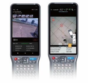
Image surveying, unlocking a broader array of measurement opportunities
-
360-degree panoramic augmented reality stakeout, where the controller and receiver collaborate to streamline the stakeout process
-
Eyr’s capability for 3D modeling applications makes it an ideal choice for integrating UAVs with GNSS RTK receivers.
While the Freyja serves as a base station, providing UAVs with precise correction data to enhance deliverable accuracy and navigation, the Eyr acts as a collaborative instrument, enabling UAVs to gather extensive image data from the ground.
For a thorough understanding, read the complete case study or visit Satlab’s official website for further details.


