
FT Technologies’ case study, “UAV-Enhanced Atmospheric Profiling”, investigates the advantages of drone-based wind measurement for improved safety and effectiveness in rocket launches.
Introduction
The UAV-based atmospheric profiling system, developed by the Łukasiewicz – Institute of Aviation, serves as a vital component alongside customary meteorological balloons to support the launch of ILR-33 AMBER rockets.
Monitoring wind speed and direction during the initial flight phases is essential, as the rocket’s velocity can closely match wind speeds. The atmospheric wind profile at low altitudes can greatly influence the rocket’s trajectory, making precise data critical for a accomplished launch.
Conventional sources of near-ground wind data, such as wind towers and atmospheric numerical models, have their drawbacks. Wind towers can be prohibitively expensive and impractical at manny launch test sites, while numerical models often fail to accurately represent localized conditions due to their broad spatial resolution (ranging from 2 to over 10 km). Additionally, meteorological balloons are not ideal for these measurements, as thay primarily provide high-altitude wind profiles and are typically deployed only once or twice per launch attempt.
project Overview
this initiative aimed to create a prototype for a wind measurement system capable of capturing near-ground wind profiles. It emphasized the need for frequent measurements of wind direction and speed, providing timely data just before launch. The atmospheric profiling system comprises a UAV equipped with an ultrasonic wind sensor.
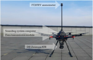
The system features a DJI Matrice 600 pro UAV, outfitted with an FT Technologies ultrasonic anemometer, an onboard computer, a data transmission link, and a ground control station equipped with software to execute user-defined flight paths and process data to generate wind profile graphs.
The ultrasonic anemometer was securely mounted on the hexacopter frame of the DJI Matrice 600 Pro. To reduce interference from rotor-induced airflow, the sensor was strategically placed at a safe distance from the rotors, ensuring alignment with the UAV’s axis and maintaining a parallel orientation to true north. The anemometer’s computer frame was produced using Multi Jet Fusion 3D printing technology, incorporating carbon fiber composites for the mast and centre plate.
The UAV follows a pre-defined flight path while the measurement system gathers and relays atmospheric data back to the ground station. The software on the ground control station is specifically designed to visualize this data effectively.
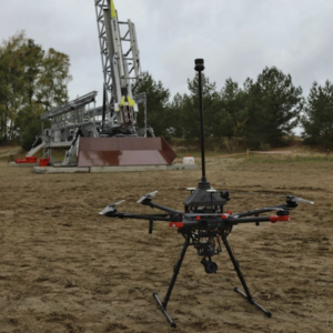
the system underwent testing in real-world flight conditions, successfully conducting automated flights up to 500 meters above ground level. A Specific Operations Risk Assessment (SORA) was performed, and approval was granted by the Polish Civil Aviation Authority to execute the mission, in collaboration with SORA ASSISTANCE from the Łukasiewicz – Institute of Aviation.
Final Thoughts
The deployment of UAVs equipped with complex wind sensors offers a promising avenue for acquiring real-time, accurate wind data that can enhance the safety and success of rocket launches.
Precise wind profiling is vital for ensuring high safety standards and success rates in rocket launches. UAVs, as a cost-effective and efficient solution, can deliver reliable wind data that significantly contributes to the safety of these operations.
The successful application of this prototype during a suborbital rocket launch campaign illustrates the potential for integrating UAVs with specialized sensors to conduct regular meteorological measurements autonomously.


