
Kongsberg Geospatial Unveils TerraLens 9.3: A leap Forward in Geospatial Visualization
Enhanced Performance and Multi-Domain Capabilities
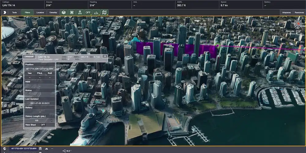
The latest iteration of Kongsberg Geospatial’s TerraLens, version 9.3, has been launched, showcasing significant enhancements in real-time geospatial visualization.This update emphasizes improved performance, advanced multi-threading capabilities, and compatibility with OGC 3D Tiles, making it a robust tool for various applications.
Focusing on optimizing 3D visualization for expansive viewports,the growth team has integrated features that cater to Joint All-Domain command and control systems. By harnessing the capabilities of contemporary GPUs and multi-core processors,TerraLens 9.3 delivers a notably faster experiance,enhancing situational awareness through innovative presentations.
Smooth Map Handling and Speedy Access
With its upgraded multi-threading in map processing, TerraLens can efficiently load and display vector, raster, and elevation data without the need for pre-processing. This is particularly beneficial for applications constrained by disk space or those requiring rapid updates to map data.
For scenarios where immediate access to map formats is critical, the option for pre-processing remains available, ensuring that initial map displays are rendered with minimal delay.
Optimized Rendering and Dynamic Presentations
The rendering process for maps and dynamic content has been fine-tuned, featuring enhanced threading within the graphics kernel. This minimizes expensive graphics state changes through batched rendering calls, ensuring that only visible elements are rendered. These optimizations are especially beneficial when managing numerous dynamic tracks and frequently updated facts.
New Features and Visual Enhancements
“While our primary focus is on performance, we have also taken into account our customers’ feedback for impactful visual presentations,” stated Annette Gottstein, the product manager for TerraLens.
Among the new features is support for OGC 3D Tiles, enabling the creation of high-resolution 3D views ideal for urban environments. additionally, a new API allows developers to control terrain mesh resolution, balancing runtime efficiency with higher-quality terrain imagery.
Elevation alerts can now be visually represented using color gradients on both terrain and OGC 3D Tiles, as well as on basic lines and area fills. Furthermore, TerraLens 9.3 introduces new Geo/WorldHeatMap classes, offering developers innovative ways to visualize point density on maps. The SDK also includes the latest military symbology, supporting MIL-STD-2525D and App-6B symbol sets.
Mapping Updates and Development Environment Support
The SDK has been updated to enhance the discovery of WMS and WMTS map layers, along with monitoring web request statuses. Support for DAFIF 8.1 and S-57 Inland ENC levels has also been integrated, allowing developers to track the loading status of maps within the TerraLens viewport.
Continuing to meet the demands of modern development environments, TerraLens 9.3 supports Visual Studio 2019, CLI .Net Core, and Linux RedHat8.
Commitment to Innovation
“kongsberg Geospatial is dedicated to the ongoing evolution of our TerraLens geospatial visualization SDK,” remarked Ranald McGillis,President of Kongsberg Geospatial. “our significant investment in research and development over recent years has culminated in this version of TerraLens, which we are excited to share with engineers and developers.”


