News / Discover the Cutting-Edge Innovations of SBG Systems /

YellowScan Launches Enhanced UAV LiDAR Scanning Solutions for Next-Level Precision

sbg systems.webp

Inertial Navigation Systems, INS/GPS, AHRS, and IMU Sensors for Unmanned Systems

YellowScan Launches Enhanced UAV LiDAR Scanning Solutions for Next-Level Precision

The redesigned Surveyor Ultra and Explorer LiDAR systems are being showcased at INTERGEO 2023


YellowScan Launches Enhanced LiDAR Solutions for UAVs

YellowScan has introduced upgraded versions of its LiDAR scanning solutions, the Surveyor Ultra and Explorer, designed specifically for unmanned aerial vehicles (UAVs). These innovative products will be featured at the upcoming INTERGEO 2023 exhibition in Berlin.

Lightweight and Versatile: The New Explorer

The latest iteration of the YellowScan Explorer has seen a notable weight reduction, now weighing just 1.8kg, down from 2.3kg. This change enhances its compatibility with a broader range of drone platforms. Additionally, the Explorer can now be mounted on ground-based mobile mapping vehicles, expanding its usability. A newly integrated front-facing LCD screen provides real-time updates on the system’s status,while an embedded global shutter camera has been included to facilitate colorization.

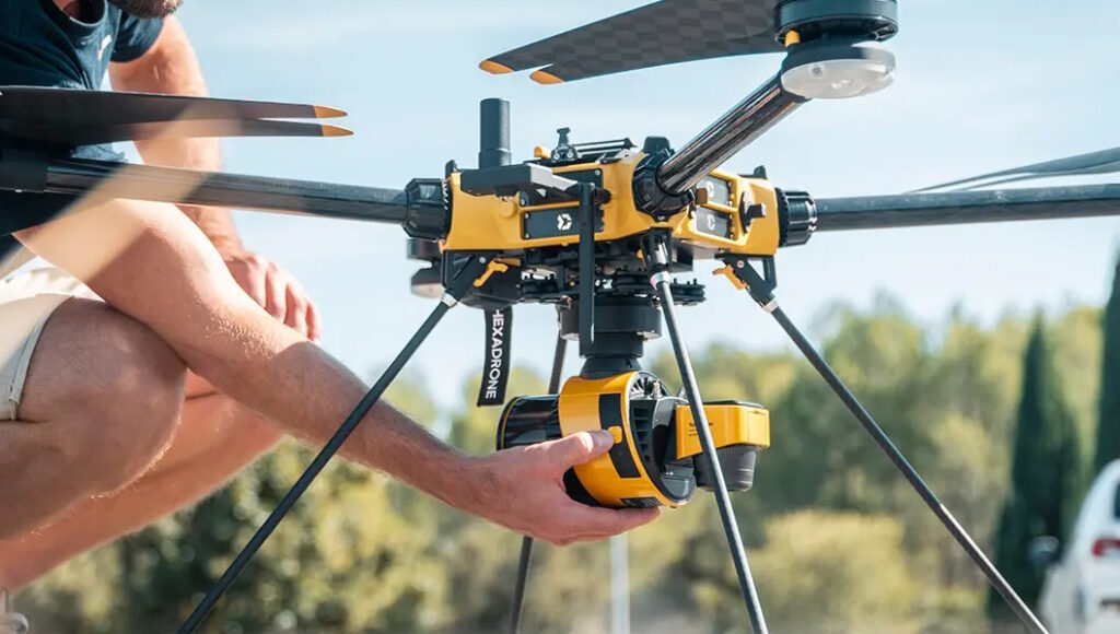
Surveyor Ultra: A Compact powerhouse

The Surveyor Ultra has also undergone a transformation, with its weight decreasing from 1.32kg to an impressive 983g. Users can now choose between an optional 20MP or 60MP single-camera module,or a 35MP dual-camera module. This model also features a new embedded global shutter camera and enhanced LED icons on the side for improved visibility, even in bright environments.

Advanced Navigation and User-Friendly Features

Both LiDAR systems have been upgraded with the Quanta Micro GNSS-aided inertial navigation solution from SBG Systems, which significantly boosts accuracy and overall performance. Moreover, YellowScan has developed a complimentary mobile request for both Android and iOS platforms. This app allows users to connect their YellowScan systems via Bluetooth, adjust LiDAR settings, and operate the systems remotely, enhancing user experience and operational efficiency.

Upcoming Demonstrations and Events

YellowScan will showcase its latest innovations not only at INTERGEO but also at the YellowScan LiDAR Convention scheduled for March 2024 in Montpellier.For more details,click here to learn more about these exciting developments.

sbg feature product.webp
Inertial Navigation Systems, INS/GPS, AHRS, and IMU Sensors for Unmanned Systems

Carrières-sur-seine, 78420

Send Message

Supplier's Products

Unlocking Precision: Discover the Ekinox-D GNSS/INS Solution!
Advanced inertial navigation system with integrated RTK GNSS for drones and robotics
Unlocking Precision: Discover the Ekinox-E GNSS/INS Solution!
Externally-aided tactical-grade MEMS INS for UAVs and unmanned systems
Discover the Ekinox-A: The Ultimate AHRS/MRU Solution!
Advanced tactical-grade MEMS AHRS/MRU for UAVs and unmanned systems
Unlock Precision: Discover the Ellipse-D Dual Antenna GNSS/INS!
Dual antenna survey-grade GNSS-INS with RTK in rugged enclosure for UAVs and unmanned systems
Unlocking Precision: The Power of Ellipse-N GNSS/INS
Single-antenna GNSS-INS in rugged compact package for drones and unmanned systems
Discover the Power of Precision with Ellipse-A AHRS!
Miniature AHRS in rugged enclosure for drones and robotics
Discover the Ellipse-E: The Compact Powerhouse of Inertial Navigation!
Miniature INS with external GNSS receiver connectivity for UAVs and robotics
Unlocking Potential: The Power of Apogee-E INS
Highly versatile Inertial Navigation System
Unlocking Precision: The Power of Apogee-D INS/GNSS
High performance and high accuracy Inertial Navigation System
Discover the Power of Precision: Pulse-40 IMU Unleashed!
Miniature tactical-grade 6 DoF IMU for UAVs & unmanned systems
Unlocking Innovation: The Power of Quanta Micro
High performance IMU in an extremely compact form factor
Unlocking the Power of Quanta Plus: A Game-Changer in Innovation!
GNSS-aided Inertial Navigation System designed for UAV and land-based surveying solutions
Unlocking the Power of Quanta Extra: Elevate Your Experience!
The most accurate INS/GNSS system for demanding survey applications
Transform Your Workflow with Qinertia Post-Processing Software!
SBG Systems’ in-house INS/GNSS post-processing software

More News from Discover the Cutting-Edge Innovations of SBG Systems